Difference between revisions of "2010-08-07 52 0"
From Geohashing
imported>Sourcerer m |
imported>Sourcerer m |
||
| Line 27: | Line 27: | ||
Image:2010_08_07_52_0_juggernaut.jpg|Juggernaut Evidence. | Image:2010_08_07_52_0_juggernaut.jpg|Juggernaut Evidence. | ||
</gallery> | </gallery> | ||
| + | |||
| + | == Other geohashing expeditions on the same day == | ||
| + | |||
| + | {{expedition summaries|2010-08-07}} | ||
[[Category:Meetup on 2010-08-07]] | [[Category:Meetup on 2010-08-07]] | ||
Revision as of 12:22, 25 November 2010
Contents
Location
In a elderberry tree near Syderstone, Norfolk, United Kingdom. The hash point was right beside a bridle path and very easy to get to. Wikiloc
| Sat 7 Aug 2010 in Cambridge: 52.8714800, 0.7146075 geohashing.info google osm bing/os kml crox |
Participants
Expedition
This was Sourcerer, Neil's first ever geohash. He visited the tree as part of a day trip to the north Norfolk coast. Brambles made it impossible to reach the exact coordinates but the GPS receiver said it was within 3 metres. As the device is accurate to +/- 4 metres under ideal conditions, I believe this counts.
Image Gallery

Neil. Manic -Grin.
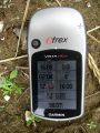
Satnav Evidence.
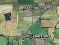
Google Earth Path.
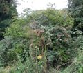
The Elderberry Tree and Brambles.
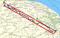
Juggernaut Evidence.


Other geohashing expeditions on the same day
Expeditions and Plans
| 2010-08-07 | ||
|---|---|---|
| Auckland, New Zealand | Greenslime | On the edge of Chamberland Park Golf Course, Point Chevalier, Auckland |
| Nogales, Arizona | Wyle, RoadRunner, Wyle & RoadRunner, Jen | Off Highway 83, north of Sonita |
| Springfield, Massachusetts | Sara | In a field in Marlboro, Vermont. |
| Bruxelles, Belgium | Someone went | Not even 50 meters away from a great party. |
| Cambridge, United Kingdom | Sourcerer | In a elderberry tree near Syderstone, Norfolk, United Kingdom. The hash poi... |
| Edson, Alberta | B cereus | located near Silver Summit ski hill. |
| Oslo, Norway | eiggen, relet, W, Flexable777 | On a small island in the Oslofjord, known for its beaches and its camping g... |
| Vantaa, Finland | marcius | These coordinates were located in the middle of nowhere near Orimattila, Fi... |