2010-08-11 52 1
From Geohashing
Revision as of 12:24, 25 November 2010 by imported>Sourcerer
Contents
Location
In a wheat field north of Laxfield, Suffolk, United Kingdom. The hash point was on a public footpath path and easy to get to. There is a GPS path here at wikiloc.
The return route was less easy. Although using public footpaths, there were three deep unbridged drainage ditches to negotiate. These needed some agility and a willingness to ignore water, mud, nettles and thistles. It was obvious from the vegetation that others had performed a glassade (a glisade performed by sliding on ones rear end) in order to cross the ditches.
| Wed 11 Aug 2010 in Norwich: 52.3196175, 1.3508862 geohashing.info google osm bing/os kml crox |
Participants
Expedition
Sourcerer (Neil) went on a 5 mile walk starting and ending in Laxfield with a convenient pub at the end of the walk.
Image Gallery
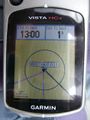
Satnav Evidence.
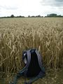
Wheat Field 1.
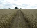
Wheat Field 2.
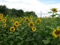
Sun Flower Field.


Other geohashing expeditions on the same day
Expeditions and Plans
| 2010-08-21 | ||
|---|---|---|
| Paducah, Kentucky | Spork | Near Massac, KY |
| Atlantic City, New Jersey | Jevanyn, Gwynnath, Evan | It looks like an empty lot on Surf Dr., in North Wildwood. Landward side b... |
| Boston, Massachusetts | Wwwi7891 | The Buck Hill Management Area in Pascoag, RI. Relatively secluded public wo... |
| Manitowoc, Wisconsin | Bassoon, Dedehawk, PainJain | In a church near St. Nazianz, Wisconsin. |
| Seattle, Washington | OtherJack | On a suburban streetside in Lacey, WA (near Olympia) |
| North Cascades National Park, Washington | AeroIllini | Our first attempt was made at a turnoff on Woods Creek Rd. The sign at the ... |
| Calgary NE, Alberta | air384, Chris, Brett | On the side of Range Road 235A, near the fence. |
| Esbjerg, Denmark | Ekorren, dawidi, AE, Schorhr | Ekorren started in Stuttgart not long after midnight and rode intercity tra... |
| Gjøvik, Norway | Blóðøx, Snoken | Woodland, just north of Oslo. |
| Unarin-Luusua, Finland | isopekka, son, dog. | About 60 km north of Rovaniemi, in wilderness. Can be almost reached by car... |