Difference between revisions of "2010-10-25 48 12"
imported>Zb (→Plans) |
imported>FippeBot m (Location) |
||
| (39 intermediate revisions by 4 users not shown) | |||
| Line 1: | Line 1: | ||
| − | |||
| − | |||
| − | |||
| − | |||
| − | |||
| − | |||
| − | |||
| − | |||
| − | |||
| − | |||
{{meetup graticule | {{meetup graticule | ||
| lat=48 | | lat=48 | ||
| Line 15: | Line 5: | ||
}} | }} | ||
| − | |||
| − | |||
== Location == | == Location == | ||
| − | + | In Köfering, on what looks like a farm yard or small industrial facility. Might not be accessible, but the option of meeting Dawidi in Regensburg still makes it worth trying. | |
== Participants == | == Participants == | ||
| − | + | * [[User:Robyn|Robyn]] | |
| + | * [[User:Wade|Wade]] | ||
| + | * [[User:Ekorren|Ekorren]] | ||
| + | * [[User:Dawidi|dawidi]] | ||
| + | * [[User:Zb|zb]] | ||
| + | * [[User:Tanya|Tanya]] | ||
| + | |||
| + | == The current überplannen == | ||
| + | The current plan is this: Robyn, Wade & Ekorren will arrive at Köfering at 15:22 via München where they will have locked up their luggage and been joined by zb. | ||
| + | |||
| + | It is 1.5 km from the Köfering Bahnhof to the geohash. One hundred metres from the geohash is a bus stop where we can catch a bus to Regensburg at 16:13 or 16:43, (25 minute trip). | ||
| + | |||
| + | Everyone is welcome to join at any point on the trip, and sharing those fancy 5-in-1 railroad ticket things is encouraged. | ||
| + | |||
| + | More details below. | ||
| + | |||
| + | This is the schedule: | ||
| + | Tübingen 9:15 | ||
| + | ... | ||
| + | Ulm 11:02 / 11:24 | ||
| + | München 13:22 / 13:44 | ||
| + | Eggmühl 14:59 / 15:12 | ||
| + | Köfering 15:22 | ||
| + | (walk to hash and then to the busstop) | ||
| + | Köfering Schloss 16:13 by bus | ||
| + | Regensburg Hbf 16:40 (or get off a stop earlier which might be closer to the centre) | ||
| + | This variant has several advantages: It allows to leave the luggage at München, which makes the walking part easier and faster, and there are 7 minutes more of time at Köfering. Together with using the bus back it will give us enough time at Köfering to not be in a hurry, and still leaves about 3 hours at Regensburg. --[[User:Ekorren|Ekorren]] 18:47, 24 October 2010 (UTC) | ||
| − | |||
===The general idea=== | ===The general idea=== | ||
| − | [[User:Robyn|Robyn]] and [[User:Wade|Wade]] from Vancouver, Canada, are in Germany and plan to travel from the Heidelberg or Tübingen area to München. As can be expected from geohashers with attitude (GWA), they don't just take the straight connection, but want to (i) see stuff on the way and (ii) log successful geohashes while doing so. As of 2010-10-23, they are exploring BaWü with [[User:Ekorren|Ekorren]] and plan to leave his home graticule on Monday morning. [[User:Ekorren|Ekorren]] found out that it would be possible to meet [[User:Dawidi|dawidi]] in Regensburg, see lots of beautiful ancient bricks there and head on this location before continuing on to München in 48 11. [[User:Zb|zb]] has the day off, so he can meet the group along the way. Everyone is happy | + | [[User:Robyn|Robyn]] and [[User:Wade|Wade]] from Vancouver, Canada, are in Germany and plan to travel from the Heidelberg or Tübingen area to München. As can be expected from geohashers with attitude (GWA), they don't just take the straight connection, but want to (i) see stuff on the way and (ii) log successful geohashes while doing so. As of 2010-10-23, they are exploring BaWü with [[User:Ekorren|Ekorren]] and plan to leave his home graticule on Monday morning. [[User:Ekorren|Ekorren]] found out that it would be possible to meet [[User:Dawidi|dawidi]] in Regensburg, see lots of beautiful ancient bricks there and head on to this location before continuing on to München in 48 11. [[User:Zb|zb]] has the day off, so he can meet the group along the way. Everyone is happy if others join in somewhere along the way. --[[User:Zb|Zb]] 08:48, 23 October 2010 (UTC) |
===Schedules=== | ===Schedules=== | ||
| − | + | See the überplannen above. Getting to München from Regensburg after going sightseeing there will not be so hard that we have to figure out the details before. --[[User:Zb|Zb]] 19:53, 24 October 2010 (UTC) | |
| − | + | ===Tickets=== | |
| − | + | Ekorren, for what parts of the trip will you have your own tickets? Are you using an IC/ICE from München to Ulm at night? I'm thinking about bringing a By-Ticket to Ulm, which would have to have my name on it, could be used by us throughout the day and would also be good for Robyn, Wade and me in München after we get to München Hbf. --[[User:Zb|Zb]] 18:13, 24 October 2010 (UTC) | |
| − | |||
| − | |||
| − | |||
| − | |||
| − | + | :I won't have any other ticket than the Bayern-Ticket for Bayern. Current plan is: | |
| + | :*Go to Ulm with the Bayern-Ticket on a late train (22:02 from München, 0:01 at Ulm) | ||
| + | :*Buy a ticket for the IC from Ulm to Plochingen, pretending to want to continue to Tübingen by RE with the Baden-Württemberg-Ticket from the morning | ||
| + | :*Try to convince DB to pay for a taxi from Stuttgart to Tübingen because the IC was late and missed the train to Tübingen (this might be different in case the RE waits for the IC. The IC being in time is something that basically doesn't happen, though) | ||
| + | zb will buy a day pass for München's public transport that he will use to get to München Hbf to meet everyone. This pass will also be good for Robyn, Wade and zb after coming back to München Hbf at night. --[[User:Zb|Zb]] 19:58, 24 October 2010 (UTC) | ||
== Expedition == | == Expedition == | ||
| − | <!-- | + | With that amount of planning, you're probably expecting a smoothly executed expedition, and that's what we had. |
| + | ===Getting There=== | ||
| + | ====Wade, Robyn & Ekorren==== | ||
| + | |||
| + | ... got up rather early, but not ''that'' early, anyway. The trains were all in time (for sufficient values of "in time"), no significant problems arouse. How boring. | ||
| + | |||
| + | When reaching München, zb waited for us as a local guide, the heavy luggage was put into storage, and we got on a train to Regensburg, which we left at the small station of Eggmühl in the [[wikipedia:Conium#Socrates|Schierling]] municipality. Surprisingly we survived even that, and a small local train took us from there to Köfering. | ||
| + | |||
| + | ===Six Geohashers in Köfering=== | ||
| + | Shortly after the Tübingen/Munich part of the expedition team arrived at Köfering, another train arrived from Regensburg, and Tanya (from [[Landshut, Germany|48 12]] on her first expedition) and dawidi emerged. | ||
| + | |||
| + | Now complete, they walked northwest through the village towards the coordinates, with ekorren urging them to keep up a good pace, since they had only 45 minutes to spend on the geohash. The village's Bahnhofstraße wound around its little houses in the approximate direction of the geohash and the group followed. Inside a garden that we passed, a dog came enthusiastically towards the fence and jumped up on its hind legs to see the unexpected activity in its town, but our cries of "hashdog!" and a raised camera set it barking. When its owner responded in scolding tones, the non-Germans turned to the Germans to know what was said. Were we being scolded, or was the dog? The Germans turned to Dawidi, similarly seeking an explanation, but he claimed no knowledge of the local dialect (<span style="font-size:x-small;">he now thinks it was probably "that's what you get for talking to it"</span>). | ||
| + | |||
| + | Actually, we should have been warned by a sign on the gate, but we met the dog first before anyone could notice the sign. The sign said something like this: ''Beware of free running dog. If dog arrives, lay flat on the ground and wait for help. If no help approaches, good luck.'' Sorry, owners - you should really put up another sign at the corner of your property if you expect people to lay down flat on the street! | ||
| + | |||
| + | We turned the next corner and found the local Bäckerei, but its hours indicated that it was open only for a few hours in the morning and again for a couple in the afternoon, but only some weekdays, not today. I guess if you live there you are careful to get bread on the correct schedule. The bakery was the only business we saw. | ||
| + | |||
| + | The last bit of road to the hash went through some kind of semi-abandoned-looking farmyard with a sign of the local boxing club, but there were cars going through the place to get to the next village, and no no-trespassing sign in sight, so they walked in and easily reached the exact spot - just under the projecting roof of a barn. | ||
| + | |||
| + | Pictures (and pictures of pictures, <span style="font-size:x-small;">all the way down</span>) were taken, and since nobody had remembered to bring chalk, they pushed some leaves on the ground around to say "xkcd". An attempt at people-letters was also performed. A video of the attempt would probably reveal everything you need to know about the character of our expedition <span style="font-size:x-small;">(dawidi isn't so sure about that, but [http://www.youtube.com/watch?v=pQ_gM_4xkZA here is one])</span>. There was space for geohashing games and activities at the actual site, but we opted to make today's geohashing activity "historic touring." | ||
| + | |||
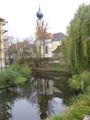
| + | With about 15 minutes remaining, they paid a quick visit to the nearby moated castle. The entrance to was through an archway, across a cobblestone yard and then over a stone bridge to cross the moat. As we approached the bridge, a gardener with a whellbarrow came by and we asked if it was possible to go inside the castle. He was friendly but said, "No," then "Listen, you can hear why not." He went across the bridge and when he opened the gate we caught a glimpse of an inner courtyard and the shape of at least one fiercely barking dog inside. The geohashers satisfied themselves with photographs on the bridge. They returned to the bus stop and, shortly after, were on their way to Regensburg. | ||
| + | |||
| + | ===A Tour of Regensberg=== | ||
| + | Dawidi led the group from the central station to an area between two preserved portions of early town walls, the oldest one was built by the Romans around the second century AD, in an attempt to keep out marauding Germanic tribesmen. The bricks were huge, and expertly shaped and fitted together. The conclusion was that when the Romans put a stone somewhere, it stays put. This theme was echoed as the tour continued with a Roman era wall that had been unearthed during the construction of a parking garage. It's still there, forming part of the parking garage, with every impression of being something that will remain there long after the parking garage is demolished to make way for a hoverport. Roman stones were also visible in the foundations of other buildings in the city. | ||
| + | |||
| + | The tour itself is best viewed in pictures, so see below. If you were there and haven't added your best pictures yet, please do! | ||
| + | |||
| + | After the light had faded too much to see the architecture, everyone went up to a mall over the main train station to try to see the city lights, but all we could see was the towers of the tallest cathedral. Unable to figure out a way to get on top of the cathedral, we went grocery shopping for train snacks, then all went our separate ways: six geohashers from five different graticules and three different national origins. | ||
| + | |||
| + | ===Back to München=== | ||
| + | This was by train, as you would expect. The most notable part is that Robyn and Wade ended up at a different place than they started, because zb took them home, thereby earning the abduction achievement. He took very good care of them, too. | ||
== Tracklog == | == Tracklog == | ||
<!-- if your GPS device keeps a log, you may post a link here --> | <!-- if your GPS device keeps a log, you may post a link here --> | ||
| + | |||
| + | |||
== Photos == | == Photos == | ||
| − | <!-- | + | |
| − | + | === The story === | |
| − | --> | + | <gallery perrow=5> |
| − | <gallery | + | File:2010-10-25_48_12_e_Koefering_Stationname.JPG|Reached Köfering |
| + | File:2010-10-25_48_12_e_Koefering_Station_2.JPG|We arrived by different trains on different routes | ||
| + | File:2010-10-25_48_12_e_Koefering_gettingoff.JPG|zb proves to be a gentleman | ||
| + | File:2010-10-25 48 12 widi walking through koefering.jpg|Walking through Köfering... | ||
| + | File:2010-10-25_48_12_e_Boxclub.JPG|It's a... boxing club? That might be dangerous... | ||
| + | File:2010-10-25_48_12_e_HashBarn.JPG|Closing in... it's at this barn | ||
| + | File:2010-10-25_48_12_e_HashBarnRoof.JPG|Under this roof. Not inside. Reachable. | ||
| + | File:2010-10-25 48 12 widi at the hash.jpg|And here we are. | ||
| + | File:2010-10-25 48 12 widi recursive documentation.jpg|lots of cameras, lots of GPSes | ||
| + | File:2010-10-25_48_12_e_GPS.JPG|Coordinates reached. You should at least believe one of them! | ||
| + | File:2010-10-25_48_12_e_Marker_Leaves.JPG|Temporary marker | ||
| + | File:2010-10-25_48_12_e_Marker_Humans.JPG|Even more temporary marker | ||
| + | File:2010-10-25 48 12 widi wasserschloss koefering.jpg|Checking out a moated castle nearby. | ||
| + | File:2010-10-25 48 12 widi everyone laughing.jpg|Joking around near the castle | ||
| + | File:2010-10-25_48_12_e_Group_Schloss.JPG|Group photo with castle | ||
| + | File:2010-10-25_48_12_e_Group_close.JPG|All six of us | ||
| + | File:2010-10-25 48 12 widi on the bus.jpg|On the bus to Regensburg. | ||
| + | File:2010-10-25 48 12 widi sightseeing bridge 2.jpg|We enjoyed post-hash... | ||
| + | File:2010-10-25 48 12 widi sightseeing bridge.jpg|...sightseeing in Regensburg. | ||
| + | File:2010-10-25 48 12.romanwall.jpg|zb, Wade & Dawidi examine stones laid by Romans | ||
| + | File:2010-10-25_48_12_e_Regensburg_dawidi.JPG|From when is this one? | ||
| + | File:2010-10-25 48 12.map.jpg|Dawidi & Tanya look at a map of Regensburg as of 1700 AD | ||
| + | File:2010-10-25_48_12_e_Regensburg_Map.JPG|Or maybe this map is better? | ||
| + | File:2010-10-25_48_12_e_Regensburg_Map_closeup.JPG|This map is also outdated by a few centuries | ||
| + | File:2010-10-25_48_12_e_Regensburg_Units.JPG|Robyn calibrates the length of her arm according to an official local cubit. | ||
| + | </gallery> | ||
| + | |||
| + | === More impressions from Köfering === | ||
| + | |||
| + | <gallery> | ||
| + | File:2010-10-25_48_12_e_Roadnames.JPG|<i>Station road<br>At the railway embankment<br>At the station</i><br>I sense a certain theme in these road names... | ||
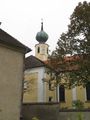
| + | File:2010-10-25_48_12_e_Koefering_Church_1.JPG|Church | ||
| + | File:2010-10-25_48_12_e_Koefering_Church_2.JPG | ||
| + | File:2010-10-25_48_12_e_Koefering_Church_3.JPG | ||
| + | File:2010-10-25_48_12_e_Koefering_Schloss_1.JPG|Castle | ||
| + | File:2010-10-25_48_12_e_Koefering_Schloss_2.JPG | ||
| + | File:2010-10-25_48_12_e_Koefering_Schloss_3.JPG | ||
| + | File:2010-10-25_48_12_e_Koefering_Schloss_4.JPG|Red and white? Are we in Franconia or wuht? | ||
| + | </gallery> | ||
| + | |||
| + | === More impressions from Regensburg === | ||
| + | |||
| + | <gallery> | ||
| + | File:2010-10-25_48_12_e_Regensburg_HistMus.JPG | ||
| + | File:2010-10-25_48_12_e_Regensburg_Nachtschicht.JPG | ||
| + | File:2010-10-25_48_12_e_Regensburg_Donau.JPG | ||
| + | File:2010-10-25_48_12_e_Regensburg_Bridge.JPG | ||
| + | File:2010-10-25_48_12_e_Regensburg_Panorama.JPG | ||
| + | File:2010-10-25_48_12_e_Regensburg_Dom.JPG | ||
| + | File:2010-10-25_48_12_e_Regensburg_Hbf.JPG | ||
</gallery> | </gallery> | ||
| Line 57: | Line 152: | ||
| − | |||
| − | |||
| − | |||
| − | |||
| − | |||
| − | |||
| − | |||
| − | |||
| − | |||
[[Category:Expeditions]] | [[Category:Expeditions]] | ||
| − | |||
[[Category:Expeditions with photos]] | [[Category:Expeditions with photos]] | ||
| − | |||
| − | |||
| − | |||
| − | |||
| − | |||
[[Category:Coordinates reached]] | [[Category:Coordinates reached]] | ||
| − | + | {{location|DE|BY|R}} | |
| − | |||
| − | |||
| − | |||
| − | |||
| − | |||
| − | |||
| − | |||
| − | |||
| − | |||
Latest revision as of 04:21, 9 August 2019
| Mon 25 Oct 2010 in 48,12: 48.9375992, 12.1934044 geohashing.info google osm bing/os kml crox |
Contents
Location
In Köfering, on what looks like a farm yard or small industrial facility. Might not be accessible, but the option of meeting Dawidi in Regensburg still makes it worth trying.
Participants
The current überplannen
The current plan is this: Robyn, Wade & Ekorren will arrive at Köfering at 15:22 via München where they will have locked up their luggage and been joined by zb.
It is 1.5 km from the Köfering Bahnhof to the geohash. One hundred metres from the geohash is a bus stop where we can catch a bus to Regensburg at 16:13 or 16:43, (25 minute trip).
Everyone is welcome to join at any point on the trip, and sharing those fancy 5-in-1 railroad ticket things is encouraged.
More details below.
This is the schedule:
Tübingen 9:15
...
Ulm 11:02 / 11:24
München 13:22 / 13:44
Eggmühl 14:59 / 15:12
Köfering 15:22
(walk to hash and then to the busstop)
Köfering Schloss 16:13 by bus
Regensburg Hbf 16:40 (or get off a stop earlier which might be closer to the centre)
This variant has several advantages: It allows to leave the luggage at München, which makes the walking part easier and faster, and there are 7 minutes more of time at Köfering. Together with using the bus back it will give us enough time at Köfering to not be in a hurry, and still leaves about 3 hours at Regensburg. --Ekorren 18:47, 24 October 2010 (UTC)
The general idea
Robyn and Wade from Vancouver, Canada, are in Germany and plan to travel from the Heidelberg or Tübingen area to München. As can be expected from geohashers with attitude (GWA), they don't just take the straight connection, but want to (i) see stuff on the way and (ii) log successful geohashes while doing so. As of 2010-10-23, they are exploring BaWü with Ekorren and plan to leave his home graticule on Monday morning. Ekorren found out that it would be possible to meet dawidi in Regensburg, see lots of beautiful ancient bricks there and head on to this location before continuing on to München in 48 11. zb has the day off, so he can meet the group along the way. Everyone is happy if others join in somewhere along the way. --Zb 08:48, 23 October 2010 (UTC)
Schedules
See the überplannen above. Getting to München from Regensburg after going sightseeing there will not be so hard that we have to figure out the details before. --Zb 19:53, 24 October 2010 (UTC)
Tickets
Ekorren, for what parts of the trip will you have your own tickets? Are you using an IC/ICE from München to Ulm at night? I'm thinking about bringing a By-Ticket to Ulm, which would have to have my name on it, could be used by us throughout the day and would also be good for Robyn, Wade and me in München after we get to München Hbf. --Zb 18:13, 24 October 2010 (UTC)
- I won't have any other ticket than the Bayern-Ticket for Bayern. Current plan is:
- Go to Ulm with the Bayern-Ticket on a late train (22:02 from München, 0:01 at Ulm)
- Buy a ticket for the IC from Ulm to Plochingen, pretending to want to continue to Tübingen by RE with the Baden-Württemberg-Ticket from the morning
- Try to convince DB to pay for a taxi from Stuttgart to Tübingen because the IC was late and missed the train to Tübingen (this might be different in case the RE waits for the IC. The IC being in time is something that basically doesn't happen, though)
zb will buy a day pass for München's public transport that he will use to get to München Hbf to meet everyone. This pass will also be good for Robyn, Wade and zb after coming back to München Hbf at night. --Zb 19:58, 24 October 2010 (UTC)
Expedition
With that amount of planning, you're probably expecting a smoothly executed expedition, and that's what we had.
Getting There
Wade, Robyn & Ekorren
... got up rather early, but not that early, anyway. The trains were all in time (for sufficient values of "in time"), no significant problems arouse. How boring.
When reaching München, zb waited for us as a local guide, the heavy luggage was put into storage, and we got on a train to Regensburg, which we left at the small station of Eggmühl in the Schierling municipality. Surprisingly we survived even that, and a small local train took us from there to Köfering.
Six Geohashers in Köfering
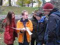
Shortly after the Tübingen/Munich part of the expedition team arrived at Köfering, another train arrived from Regensburg, and Tanya (from 48 12 on her first expedition) and dawidi emerged.
Now complete, they walked northwest through the village towards the coordinates, with ekorren urging them to keep up a good pace, since they had only 45 minutes to spend on the geohash. The village's Bahnhofstraße wound around its little houses in the approximate direction of the geohash and the group followed. Inside a garden that we passed, a dog came enthusiastically towards the fence and jumped up on its hind legs to see the unexpected activity in its town, but our cries of "hashdog!" and a raised camera set it barking. When its owner responded in scolding tones, the non-Germans turned to the Germans to know what was said. Were we being scolded, or was the dog? The Germans turned to Dawidi, similarly seeking an explanation, but he claimed no knowledge of the local dialect (he now thinks it was probably "that's what you get for talking to it").
Actually, we should have been warned by a sign on the gate, but we met the dog first before anyone could notice the sign. The sign said something like this: Beware of free running dog. If dog arrives, lay flat on the ground and wait for help. If no help approaches, good luck. Sorry, owners - you should really put up another sign at the corner of your property if you expect people to lay down flat on the street!
We turned the next corner and found the local Bäckerei, but its hours indicated that it was open only for a few hours in the morning and again for a couple in the afternoon, but only some weekdays, not today. I guess if you live there you are careful to get bread on the correct schedule. The bakery was the only business we saw.
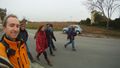
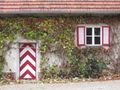
The last bit of road to the hash went through some kind of semi-abandoned-looking farmyard with a sign of the local boxing club, but there were cars going through the place to get to the next village, and no no-trespassing sign in sight, so they walked in and easily reached the exact spot - just under the projecting roof of a barn.
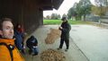
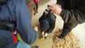
Pictures (and pictures of pictures, all the way down) were taken, and since nobody had remembered to bring chalk, they pushed some leaves on the ground around to say "xkcd". An attempt at people-letters was also performed. A video of the attempt would probably reveal everything you need to know about the character of our expedition (dawidi isn't so sure about that, but here is one). There was space for geohashing games and activities at the actual site, but we opted to make today's geohashing activity "historic touring."
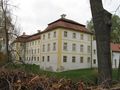
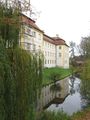
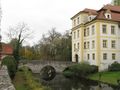
With about 15 minutes remaining, they paid a quick visit to the nearby moated castle. The entrance to was through an archway, across a cobblestone yard and then over a stone bridge to cross the moat. As we approached the bridge, a gardener with a whellbarrow came by and we asked if it was possible to go inside the castle. He was friendly but said, "No," then "Listen, you can hear why not." He went across the bridge and when he opened the gate we caught a glimpse of an inner courtyard and the shape of at least one fiercely barking dog inside. The geohashers satisfied themselves with photographs on the bridge. They returned to the bus stop and, shortly after, were on their way to Regensburg.
A Tour of Regensberg
Dawidi led the group from the central station to an area between two preserved portions of early town walls, the oldest one was built by the Romans around the second century AD, in an attempt to keep out marauding Germanic tribesmen. The bricks were huge, and expertly shaped and fitted together. The conclusion was that when the Romans put a stone somewhere, it stays put. This theme was echoed as the tour continued with a Roman era wall that had been unearthed during the construction of a parking garage. It's still there, forming part of the parking garage, with every impression of being something that will remain there long after the parking garage is demolished to make way for a hoverport. Roman stones were also visible in the foundations of other buildings in the city.
The tour itself is best viewed in pictures, so see below. If you were there and haven't added your best pictures yet, please do!
After the light had faded too much to see the architecture, everyone went up to a mall over the main train station to try to see the city lights, but all we could see was the towers of the tallest cathedral. Unable to figure out a way to get on top of the cathedral, we went grocery shopping for train snacks, then all went our separate ways: six geohashers from five different graticules and three different national origins.
Back to München
This was by train, as you would expect. The most notable part is that Robyn and Wade ended up at a different place than they started, because zb took them home, thereby earning the abduction achievement. He took very good care of them, too.
Tracklog
Photos
The story
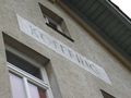
Reached Köfering
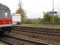
We arrived by different trains on different routes
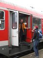
zb proves to be a gentleman
Walking through Köfering...
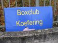
It's a... boxing club? That might be dangerous...
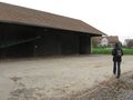
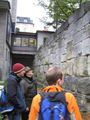
Closing in... it's at this barn
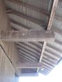
Under this roof. Not inside. Reachable.
And here we are.
lots of cameras, lots of GPSes
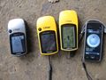
Coordinates reached. You should at least believe one of them!
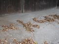
Temporary marker
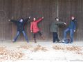
Even more temporary marker
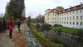
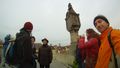
Checking out a moated castle nearby.

Joking around near the castle
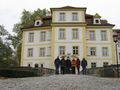
Group photo with castle
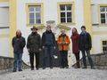
All six of us
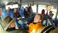
On the bus to Regensburg.
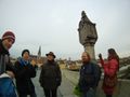
We enjoyed post-hash...
...sightseeing in Regensburg.
zb, Wade & Dawidi examine stones laid by Romans
From when is this one?
Dawidi & Tanya look at a map of Regensburg as of 1700 AD
Or maybe this map is better?
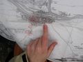
This map is also outdated by a few centuries
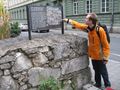
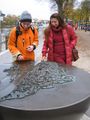
Robyn calibrates the length of her arm according to an official local cubit.


More impressions from Köfering
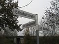
Station road
At the railway embankment
At the station
I sense a certain theme in these road names...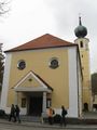
Church
Castle
Red and white? Are we in Franconia or wuht?


