Difference between revisions of "2011-05-15 43 -79"
imported>Splitdipless (→Splitdipless) |
m (More specific location) |
||
| (5 intermediate revisions by 3 users not shown) | |||
| Line 15: | Line 15: | ||
<!-- edit as necessary --> | <!-- edit as necessary --> | ||
| − | |||
== Location == | == Location == | ||
| − | + | The location of today's geohash was in the parking lot of Toronto Collegiate Institute (High School) at Midland Ave. and Rural Ave. | |
== Participants == | == Participants == | ||
| − | + | * [[User:Splitdipless|Splitdipless]] | |
== Plans == | == Plans == | ||
| − | |||
| − | Well, I guess my plans are to show up. I'm still wondering if I should go by public transit or not. I guess it depends on what my other Sunday plans are (which, I have none of yet). | + | Well, I guess my plans are to show up. I'm still wondering if I should go by public transit or not. I guess it depends on what my other Sunday plans are (which, I have none of yet).[[User:Splitdipless|Splitdipless]] |
:How easy is it to reach this area by public transit from the University of Toronto? If it's not too hard/expensive, I'd definitely consider going. -[[User:Srs0|Srs0]] 11:08, 13 May 2011 (EDT) | :How easy is it to reach this area by public transit from the University of Toronto? If it's not too hard/expensive, I'd definitely consider going. -[[User:Srs0|Srs0]] 11:08, 13 May 2011 (EDT) | ||
::Easy, but time consuming. Take the Bloor Subway to Kennedy, then take the 57 Midland to the geohash. [http://maps.google.com/maps?f=d&source=s_d&saddr=Canada+(St+George+Station+-+Eastbound+Platform)&daddr=43.7878111,+-79.2785122+(Geohashing+for+15+May+2011+in+43,-79)&geocode=CW-BuVRvGxXuFXBVmgIdN3tE-yG0oaTZJYiRaQ%3B&hl=en&mra=pd&dirflg=r&ttype=arr&date=05%2F15%2F11&time=4:00pm&noexp=0&noal=0&sort=def&sll=43.717707,-79.33907&sspn=0.250124,0.456619&ie=UTF8&t=h&z=12&start=0] [[User:Splitdipless|Splitdipless]] 06:43, 14 May 2011 (EDT) | ::Easy, but time consuming. Take the Bloor Subway to Kennedy, then take the 57 Midland to the geohash. [http://maps.google.com/maps?f=d&source=s_d&saddr=Canada+(St+George+Station+-+Eastbound+Platform)&daddr=43.7878111,+-79.2785122+(Geohashing+for+15+May+2011+in+43,-79)&geocode=CW-BuVRvGxXuFXBVmgIdN3tE-yG0oaTZJYiRaQ%3B&hl=en&mra=pd&dirflg=r&ttype=arr&date=05%2F15%2F11&time=4:00pm&noexp=0&noal=0&sort=def&sll=43.717707,-79.33907&sspn=0.250124,0.456619&ie=UTF8&t=h&z=12&start=0] [[User:Splitdipless|Splitdipless]] 06:43, 14 May 2011 (EDT) | ||
| + | |||
| + | :::I got a lot less done than I meant to today, so I don't think I'm going to have time to take an approximately two hour transit ride (plus however long at the hashpoint) tomorrow. Sorry... I'll have to meet you at a future expedition. Good luck! -[[User:Srs0|Srs0]] 01:06, 15 May 2011 (EDT) | ||
== Expedition == | == Expedition == | ||
| − | + | === Splitdipless === | |
| + | Today was a bit of a busy day, and a bit of a wet day, so instead of starting off at my 'home base' in North York, I started off on the trek from the Toronto Navy Club [http://www.navalcluboftoronto.com/]. I was supposed to take the 506 Street Car to Main Street Station, but over the course of nearly half an hour, the street cars did not appear. I suspect it had something to do with the marathon being run in the middle of the city. One finally did, but it was out of service, so I crossed the road and caught the 92 Woodbine South bus to Woodbine station instead. From there, I went to Kennedy station, and took the 57 Midland bus up to Rural Ave. | ||
| − | + | As I was getting close to the entrance to the parking lot, I noticed that there were some signs on the fence. If they once said 'no trespassing,' it had faded long ago. It was faded so much, you couldn't even make out what they might have once said. Happy that I didn't face a no trespassing sign, I walked in, and took a few snaps in the middle of the parking lot. | |
| − | + | ||
| + | For the way back, I walked down a block to Sheppard Ave. to catch the 85A Sheppard East, transferred to the Sheppard Subway at Don Mills station, switched trains at Sheppard-Yonge, and got off at North York Centre station, and finally took the 97 Yonge the last few stops to my place. | ||
| + | |||
| + | It was a wet day to use public transit, but considering that rum was consumed at the Navy Club, this geohash could be attempted no other way. | ||
== Photos == | == Photos == | ||
| − | |||
| − | |||
| − | |||
<gallery perrow="5"> | <gallery perrow="5"> | ||
| + | Image:2011-05-15 43 -79 0.7 A.jpg | If I drove, I could have parked my car at the geohash without getting wet. | ||
| + | Image:2011-05-15 43 -79 0.7 B.jpg | Instead, I wisely decided to get wet. | ||
| + | Image:2011-05-15 43 -79 0.7 C.jpg | My GPS got a bit wet too. | ||
</gallery> | </gallery> | ||
== Achievements == | == Achievements == | ||
{{#vardefine:ribbonwidth|800px}} | {{#vardefine:ribbonwidth|800px}} | ||
| − | + | {{Two to the N achievement | |
| + | | count = 5 | ||
| + | | date = 2011-05-15 | ||
| + | | latitude = 43 | ||
| + | | longitude = -79 | ||
| + | | name = Splitdipless | ||
| + | }} | ||
| − | |||
| − | |||
| − | |||
| − | |||
| − | |||
| − | |||
| − | |||
[[Category:Expeditions]] | [[Category:Expeditions]] | ||
| − | |||
[[Category:Expeditions with photos]] | [[Category:Expeditions with photos]] | ||
| − | |||
| − | |||
| − | |||
| − | |||
| − | |||
[[Category:Coordinates reached]] | [[Category:Coordinates reached]] | ||
| − | + | {{location|CA|ON|TO}} | |
| − | |||
| − | |||
| − | |||
| − | |||
| − | |||
| − | |||
| − | |||
| − | |||
| − | |||
Latest revision as of 23:42, 9 August 2020
| Sun 15 May 2011 in 43,-79: 43.7878111, -79.2785122 geohashing.info google osm bing/os kml crox |
Location
The location of today's geohash was in the parking lot of Toronto Collegiate Institute (High School) at Midland Ave. and Rural Ave.
Participants
Plans
Well, I guess my plans are to show up. I'm still wondering if I should go by public transit or not. I guess it depends on what my other Sunday plans are (which, I have none of yet).Splitdipless
- How easy is it to reach this area by public transit from the University of Toronto? If it's not too hard/expensive, I'd definitely consider going. -Srs0 11:08, 13 May 2011 (EDT)
- Easy, but time consuming. Take the Bloor Subway to Kennedy, then take the 57 Midland to the geohash. [1] Splitdipless 06:43, 14 May 2011 (EDT)
- I got a lot less done than I meant to today, so I don't think I'm going to have time to take an approximately two hour transit ride (plus however long at the hashpoint) tomorrow. Sorry... I'll have to meet you at a future expedition. Good luck! -Srs0 01:06, 15 May 2011 (EDT)
Expedition
Splitdipless
Today was a bit of a busy day, and a bit of a wet day, so instead of starting off at my 'home base' in North York, I started off on the trek from the Toronto Navy Club [2]. I was supposed to take the 506 Street Car to Main Street Station, but over the course of nearly half an hour, the street cars did not appear. I suspect it had something to do with the marathon being run in the middle of the city. One finally did, but it was out of service, so I crossed the road and caught the 92 Woodbine South bus to Woodbine station instead. From there, I went to Kennedy station, and took the 57 Midland bus up to Rural Ave.
As I was getting close to the entrance to the parking lot, I noticed that there were some signs on the fence. If they once said 'no trespassing,' it had faded long ago. It was faded so much, you couldn't even make out what they might have once said. Happy that I didn't face a no trespassing sign, I walked in, and took a few snaps in the middle of the parking lot.
For the way back, I walked down a block to Sheppard Ave. to catch the 85A Sheppard East, transferred to the Sheppard Subway at Don Mills station, switched trains at Sheppard-Yonge, and got off at North York Centre station, and finally took the 97 Yonge the last few stops to my place.
It was a wet day to use public transit, but considering that rum was consumed at the Navy Club, this geohash could be attempted no other way.
Photos
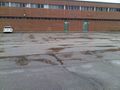
If I drove, I could have parked my car at the geohash without getting wet.

Instead, I wisely decided to get wet.
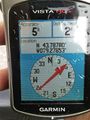
My GPS got a bit wet too.


Achievements
