Difference between revisions of "2012-03-12 52 1"
From Geohashing
imported>Sourcerer (→Achievements) |
imported>FippeBot m (Location) |
||
| (3 intermediate revisions by one other user not shown) | |||
| Line 9: | Line 9: | ||
== Location == | == Location == | ||
| − | On a public footpath | + | On a public footpath north of Mendlesham 12km south of Diss, Norfolk, UK. Logged at [http://en.wikiloc.com/wikiloc/view.do?id=2590863 Wikiloc]. |
== Participants == | == Participants == | ||
| Line 27: | Line 27: | ||
== Photos == | == Photos == | ||
| − | <gallery | + | <gallery> |
Image:2012-03-12_52_1_Sourcerer_1.jpg | Google Earth Track | Image:2012-03-12_52_1_Sourcerer_1.jpg | Google Earth Track | ||
Image:2012-03-12_52_1_Sourcerer_2.jpg | The Evidence | Image:2012-03-12_52_1_Sourcerer_2.jpg | The Evidence | ||
| Line 46: | Line 46: | ||
}} | }} | ||
| − | == | + | {{Sourcerer_links |
| + | | prev = 2012-02-20 52 1 | ||
| + | | curr = 2012-03-12 52 1 | ||
| + | | next = 2012-03-19 52 1 | ||
| + | | date = 2012-03-12 | ||
| + | }} | ||
| − | |||
| − | |||
| − | |||
| − | |||
[[Category:Expeditions]] | [[Category:Expeditions]] | ||
[[Category:Expeditions with photos]] | [[Category:Expeditions with photos]] | ||
[[Category:Coordinates reached]] | [[Category:Coordinates reached]] | ||
| + | {{location|GB|ENG|SFK}} | ||
Latest revision as of 02:52, 13 August 2019
| Mon 12 Mar 2012 in Norwich: 52.2660062, 1.0786461 geohashing.info google osm bing/os kml crox |
Contents
Location
On a public footpath north of Mendlesham 12km south of Diss, Norfolk, UK. Logged at Wikiloc.
Participants
Expedition
- Arrived. -- Sourcerer @52.2660,1.0787 17:40, 12 March 2012 (GMT)
This was a very easy expedition involving a three mile walk and a short drive to reach the area. The hashpoint was just off a public footpath. As this footpath was missing from OpenStreetMap, I have added it.
Tracklog
Logged at Wikiloc.
Photos
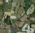
Google Earth Track
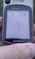
The Evidence

View by the hashpoint.
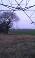
View by the hashpoint.
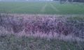
Hashpoint in the ditch.


Achievements
Sourcerer earned the OpenStreetMap achievement
|
Expeditions and Plans
| 2012-03-12 | ||
|---|---|---|
| Canberra, Australia | 1PE, Sootku, Exped 1:, * Picture was ghastly; re, Exped 2: | Canberra Nature Park, Aranda Bushland; west of Black Mountain. * behind bla... |
| Bilbao, Spain | LizWiz | Hashpoint was about 60m into a forest around Usurbil, a town near San Sebas... |
| Portland, Oregon | Michael5000 | In a backyard near Powell Boulevard in Southeast Portland. |
| Norwich, United Kingdom | Sourcerer | On a public footpath north of Mendlesham 12km south of Diss, Norfolk, UK. L... |
| Stockholm, Sweden | Carl-Johan, Henrik, zeot, Simon Lindholm, Kristian Alvarez | This hash is located close to a subway station, right next to a small road ... |
| Örnsköldsvik, Sweden | Penthok | Up in some logging ground, a bit from a road. |
| Vännäs, Sweden | Penthok | Location surveyed to be between a road and a lake, in another sliver of for... |
Sourcerer's Expedition Links
2012-02-20 52 1 - 2012-03-12 52 1 - 2012-03-19 52 1 - KML file download of Sourcerer's expeditions for use with Google Earth.