Difference between revisions of "2013-02-18 52 1"
From Geohashing
imported>Sourcerer m (An expedition message sent via Geohash Droid for Android.) |
imported>FippeBot m (Location) |
||
| (7 intermediate revisions by one other user not shown) | |||
| Line 1: | Line 1: | ||
| − | |||
| − | |||
| − | |||
| − | |||
| − | |||
| − | |||
| − | |||
| − | |||
| − | |||
| − | |||
{{meetup graticule | {{meetup graticule | ||
| − | | lat=52 | + | | lat=52 |
| − | | lon=1 | + | | lon=1 |
| − | | date=2013-02-18 | + | | date=2013-02-18 |
| + | | graticule_name=Norwich | ||
| + | | graticule_link=Norwich, United Kingdom | ||
}} | }} | ||
| − | |||
| − | |||
== Location == | == Location == | ||
| − | + | ||
| + | 4) In a field of winter wheat, close to Spexhall, Halesworth, Suffolk, UK. | ||
== Participants == | == Participants == | ||
| − | |||
| − | |||
| − | + | [[User:Sourcerer|Sourcerer]] | |
| − | |||
== Expedition == | == Expedition == | ||
| − | |||
| − | == | + | *Arrived at point four of four attempts. -- [[User:Sourcerer|Sourcerer]] [http://www.openstreetmap.org/?lat=52.3749965429306&lon=1.494988203048706&zoom=16&layers=B000FTF @52.3750,1.4950] 16:15, 18 February 2013 (GMT) |
| − | + | ||
| + | [[2013-02-18 52 -1]] :: [[2013-02-18 52 -0]] :: [[2013-02-18 52 0]] :: [[2013-02-18 52 1]] | ||
| + | |||
| + | This was attempt four of four on this day. There was a convenient place to park the car and a signposted public footpath towards the hashpoint. The signposting was poor so there was every excuse to get a bit lost and go via the hashpoint. Using tractor wheel tracks, it was possible to reach the exact point. The late afternoon sun cheered up the wintery scene but failed to dispel the sneezing and sinus discomfort of the head cold. | ||
== Photos == | == Photos == | ||
| − | + | ||
| − | |||
| − | |||
<gallery perrow="5"> | <gallery perrow="5"> | ||
| + | Image:2013-02-18_52_1_Sourcerer.jpg|The Hashpoint | ||
| + | Image:2013-02-18 52 1 Sourcerer Track.jpg | Track in Google Earth | ||
</gallery> | </gallery> | ||
== Achievements == | == Achievements == | ||
| − | |||
| − | |||
| + | {{ Multihash2 | ||
| + | | count = 3 | ||
| + | | date = 2013-02-18 | ||
| + | | name = Sourcerer | ||
| + | }} | ||
| − | + | {{Sourcerer_links | |
| − | + | | prev = 2013-02-18 52 0 | |
| − | + | | curr = 2013-02-18 52 1 | |
| − | + | | next = 2013-02-19 52 1 | |
| − | + | | date = 2013-02-18 | |
| − | + | }} | |
| − | |||
| − | |||
| − | |||
[[Category:Expeditions]] | [[Category:Expeditions]] | ||
| − | |||
[[Category:Expeditions with photos]] | [[Category:Expeditions with photos]] | ||
| − | |||
| − | |||
| − | |||
| − | |||
| − | |||
[[Category:Coordinates reached]] | [[Category:Coordinates reached]] | ||
| − | + | {{location|GB|ENG|SFK}} | |
| − | |||
| − | |||
| − | |||
| − | |||
| − | |||
| − | |||
| − | |||
| − | |||
| − | |||
| − | |||
| − | |||
| − | |||
| − | |||
| − | |||
| − | |||
| − | |||
| − | |||
Latest revision as of 01:01, 14 August 2019
| Mon 18 Feb 2013 in Norwich: 52.3750652, 1.4949735 geohashing.info google osm bing/os kml crox |
Contents
Location
4) In a field of winter wheat, close to Spexhall, Halesworth, Suffolk, UK.
Participants
Expedition
- Arrived at point four of four attempts. -- Sourcerer @52.3750,1.4950 16:15, 18 February 2013 (GMT)
2013-02-18 52 -1 :: 2013-02-18 52 -0 :: 2013-02-18 52 0 :: 2013-02-18 52 1
This was attempt four of four on this day. There was a convenient place to park the car and a signposted public footpath towards the hashpoint. The signposting was poor so there was every excuse to get a bit lost and go via the hashpoint. Using tractor wheel tracks, it was possible to reach the exact point. The late afternoon sun cheered up the wintery scene but failed to dispel the sneezing and sinus discomfort of the head cold.
Photos
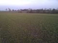
The Hashpoint
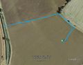
Track in Google Earth


Achievements
Sourcerer earned the Multihash Achievement
|
Expeditions and Plans
| 2013-02-18 | ||
|---|---|---|
| Zürich, Switzerland | Calamus | The Albisrieden district in Zurich. |
| Northampton, United Kingdom | Sourcerer | 2) Failed to reach agricultural land south of the A14 near Thrapston. |
| Birmingham, United Kingdom | Sourcerer | 1) An area of heath and wood surrounded by major roads and a small river, C... |
| Cambridge, United Kingdom | Sourcerer, Benjw | 3) North of the Mildenhall Air Base, Suffolk, UK. |
| Norwich, United Kingdom | Sourcerer | 4) In a field of winter wheat, close to Spexhall, Halesworth, Suffolk, UK. |
Sourcerer's Expedition Links
2013-02-18 52 0 - 2013-02-18 52 1 - 2013-02-19 52 1 - KML file download of Sourcerer's expeditions for use with Google Earth.