2013-06-23
From Geohashing
Revision as of 20:25, 22 June 2013 by imported>Mcbaneg
Expedition Archives from June 2013
Saturday 22 June 2013 | Sunday 23 June 2013 | Monday 24 June 2013
See also: Category:Meetup on 2013-06-23
Coordinates
All locations: .7840435, .9946319
Globalhash:
51.127821203882,178.067472008590
Photo Gallery

Expeditions and Plans
| 2013-06-23 | ||
|---|---|---|
| Melbourne West, Australia | Tom W, John, Cam, Felix, Steve, Lachie | On the banks of the Merri Creek, next to the Merri Creek Trail, Fitzroy Nor... |
| Washington (East), District of Columbia | OfficeLinebacker, Allison | On a playing field at Oxon Hill Elementary School |
| Würzburg, Germany | Danatar | on a small path at the town limit of Gerbrunn, next to Würzburg. Country: ... |
| Middlesbrough, United Kingdom | Mcbaneg, Katja, Rebekah, Jake, Jessica | moorland/pasture north of Stanhope on the northern rim of Weardale, County ... |
| Wonowon, British Columbia | Wijnland, Damien | west of the Alaska Hwy just of a forestry road |
| Örebro, Sweden | the ru, Anna | Within a small patch of trees on an otherwise clearcut hill. Almost within ... |
| Sun 23 Jun 2013 in 54,-1: 54.7840435, -1.9946319 geohashing.info google osm bing/os kml crox |
Location
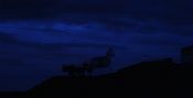
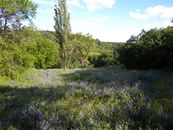
moorland/pasture north of Stanhope on the northern rim of Weardale, County Durham, UK
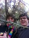
Participants
Mcbaneg (talk) (George) Katja Rebekah Jake Jessica
Plans
We're planning to head up there this evening, hoping to have enough light still at 11 pm or so to find the spot, and be there for the midnight hash.
Expedition
Photos
Achievements