2014-01-19 52 1
From Geohashing
Revision as of 17:48, 19 January 2014 by imported>Sourcerer (→Location)
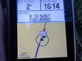
| Sun 19 Jan 2014 in Norwich: 52.4606060, 1.2545269 geohashing.info google osm bing/os kml crox |
Contents
Location
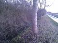
In a roadside drainage ditch half way between Norwich and Diss, Norfolk, UK.
Participants
Expedition
- Arrived. -- Sourcerer (talk) @52.4606,1.2545 16:15, 19 January 2014 (GMT)
This was about 12 miles from home and easily reached by car. The hashpoint was in a shallow drainage ditch beside a narrow country lane with agricultural land on both sites. The sun had just set and the sky was attractive. The temperature was 5C and tha air was still.
In October, Sourcerer paused his geohashing outings when his brother became ill and died. The illness turned out to be the late stages of cancer. Blood clotting caused his demise after about a month. Expeditions were resumed in late December after the funeral with two expeditions in Spain, the first in December near Malaga and the second in January in Granada.
Photos
Proof
The Hashpoint
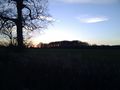
The Sunset


Other geohashing expeditions on the same day
Expeditions and Plans
| 2014-01-19 | ||
|---|---|---|
| La Pine, Oregon | Frogman, Benture, Alison, Leah, Daisy the Dog | In southern Deschutes National Forest, near Hole-In-The-Ground. |
| Mannheim, Germany | Euterkuh | Euterkuh, Schmiddi, Fivetonsofflax and some friends went on a nice walk thr... |
| Norwich, United Kingdom | Sourcerer | In a roadside drainage ditch half way between Norwich and Diss, Norfolk, UK... |
| Berlin, Germany | GeorgDerReisende | The hash lies near the Langes Luch. |