Difference between revisions of "2014-05-25 47 11"
imported>LeslieHapablap (This was the best reading I could get, my device kept losing the signal...) |
m (Location correction) |
||
| (24 intermediate revisions by 2 users not shown) | |||
| Line 9: | Line 9: | ||
And DON'T FORGET to add your expedition and the best photo you took to the gallery on the Main Page! We'd love to read your report, but that means we first have to discover it! :) | And DON'T FORGET to add your expedition and the best photo you took to the gallery on the Main Page! We'd love to read your report, but that means we first have to discover it! :) | ||
--> | --> | ||
| + | [[File:PANO 20140525 140142.jpg|left|900px]] | ||
{{meetup graticule | {{meetup graticule | ||
| lat=47 | | lat=47 | ||
| Line 14: | Line 15: | ||
| date=2014-05-25 | | date=2014-05-25 | ||
}} | }} | ||
| − | + | {{ClearLeft}} | |
<!-- edit as necessary --> | <!-- edit as necessary --> | ||
__NOTOC__ | __NOTOC__ | ||
| − | == Location == | + | == Location 2 of 3 consecutive == |
<!-- where you've surveyed the hash to be --> | <!-- where you've surveyed the hash to be --> | ||
| + | In a forest near Telfs, close to the river Inn. | ||
== Participants == | == Participants == | ||
<!-- who attended: If you link to your wiki user name in this section, your expedition will be picked up by the various statistics generated for geohashing. You may use three tildes ~ as a shortcut to automatically insert the user signature of the account you are editing with. | <!-- who attended: If you link to your wiki user name in this section, your expedition will be picked up by the various statistics generated for geohashing. You may use three tildes ~ as a shortcut to automatically insert the user signature of the account you are editing with. | ||
--> | --> | ||
| + | * [[User:LeslieHapablap|LeslieHapablap]] ([[2014-05-24 47 11|previous]]|[[2014-05-26 47 11|next]]) | ||
| + | * [[User:LeslieHapablap/Waltraud|Waltraud]] the hashkiwi | ||
== Plans == | == Plans == | ||
<!-- what were the original plans --> | <!-- what were the original plans --> | ||
| − | + | Go there by bike, walk the very last part. | |
== Expedition == | == Expedition == | ||
<!-- how it all turned out. your narrative goes here. --> | <!-- how it all turned out. your narrative goes here. --> | ||
| − | *Towel Day! Going there by bike, starting in a few minutes. -- [[User:LeslieHapablap|LeslieHapablap]] ([[User talk:LeslieHapablap|talk]]) 04:39, 25 May 2014 (EDT) | + | *[[Towel Day achievement|Towel Day]]! Going there by bike, starting in a few minutes. -- [[User:LeslieHapablap|LeslieHapablap]] ([[User talk:LeslieHapablap|talk]]) 04:39, 25 May 2014 (EDT) |
| + | |||
| + | This was a nice tour of about 60 km, almost entirely level, but my legs were still a bit sore from yesterday's expedition. I knew the route from our previous tours to [[2013-05-01 47 11|Garmisch-Partenkirchen]] and [[2013-10-26 47 11|Pettnau]]. On my way to the hashpoint I had some pleasant tailwind which allowed for a good pace. | ||
| + | |||
| + | I brought additional clothes and a second pair of shoes for the walk to the hashpoint, and of course a [[Towel Day achievement|Towel]]. Compared to yesterday's hash, this one was very easy to approach. Only my GPS device had some trouble picking up the signal in the woods, a distance of 7 m with large uncertainty was the best reading I could get. Still good enough to count it as "reached" any other spot nearby wouldn't have been more difficult to go. | ||
| + | |||
| + | On my way back I had the wind from up front, but luckily I could join two other road bikers and slipstreaming helped a lot. | ||
== Tracklog == | == Tracklog == | ||
<!-- if your GPS device keeps a log, you may post a link here --> | <!-- if your GPS device keeps a log, you may post a link here --> | ||
| Line 42: | Line 52: | ||
Image:2014-05-25_47_11_LeslieHapablap_1401017480051.jpg | This was the best reading I could get, my device kept losing the signal... | Image:2014-05-25_47_11_LeslieHapablap_1401017480051.jpg | This was the best reading I could get, my device kept losing the signal... | ||
| + | |||
| + | Image:2014-05-25_47_11_LeslieHapablap_1401011261122.jpg | Starting the expedition. | ||
| + | |||
| + | Image:2014-05-25_47_11_LeslieHapablap_1401015219024.jpg | Arriving near the hash point, my bike has to wait. | ||
| + | |||
| + | Image:2014-05-25_47_11_LeslieHapablap_1401015585059.jpg | | ||
| + | |||
| + | Image:2014-05-25_47_11_LeslieHapablap_1401061361000.jpg | | ||
| + | |||
| + | Image:2014-05-25_47_11_LeslieHapablap_1401015837580.jpg | | ||
| + | |||
| + | Image:2014-05-25_47_11_LeslieHapablap_1401016314978.jpg | | ||
| + | |||
| + | Image:2014-05-25_47_11_LeslieHapablap_1401016879125.jpg | Somewhere in there... | ||
| + | |||
| + | Image:2014-05-25_47_11_LeslieHapablap_1401061487000.jpg | Waltraud on Towel Day. | ||
| + | |||
| + | Image:2014-05-25_47_11_LeslieHapablap_1401018368700.jpg | Towel Day silly grin. | ||
| + | |||
| + | Image:PANO 20140525 133220 LeslieHapablap.jpg | Panorama of the hashpoint area. | ||
| + | |||
</gallery> | </gallery> | ||
| Line 47: | Line 78: | ||
{{#vardefine:ribbonwidth|800px}} | {{#vardefine:ribbonwidth|800px}} | ||
<!-- Add any achievement ribbons you earned below, or remove this section --> | <!-- Add any achievement ribbons you earned below, or remove this section --> | ||
| + | {{land geohash | ||
| + | |||
| + | | latitude = 47 | ||
| + | | longitude = 11 | ||
| + | | date = 2014-05-25 | ||
| + | | name = [[User:LeslieHapablap|LeslieHapablap]] | ||
| + | }} | ||
| + | {{bicycle geohash | ||
| + | | latitude = 47 | ||
| + | | longitude = 11 | ||
| + | | date = 2014-05-25 | ||
| + | | name = [[User:LeslieHapablap|LeslieHapablap]] | ||
| + | | bothways = true | ||
| + | |||
| + | }} | ||
| + | {{Towel Day | ||
| + | |||
| + | | latitude = 47 | ||
| + | | longitude = 11 | ||
| + | | date = 2014-05-25 | ||
| + | | name = [[User:LeslieHapablap|LeslieHapablap]] | ||
| + | |||
| + | }} | ||
| + | {{consecutive geohash | ||
| + | |||
| + | | count = 2 | ||
| + | | latitude = 47 | ||
| + | | longitude = 11 | ||
| + | | date = 2014-05-24 | ||
| + | | name = [[User:LeslieHapablap|LeslieHapablap]] | ||
| + | |||
| + | }} | ||
<!-- =============== USEFUL CATEGORIES FOLLOW ================ | <!-- =============== USEFUL CATEGORIES FOLLOW ================ | ||
Delete the next line ONLY if you have chosen the appropriate categories below. If you are unsure, don't worry. People will read your report and help you with the classification.--> | Delete the next line ONLY if you have chosen the appropriate categories below. If you are unsure, don't worry. People will read your report and help you with the classification.--> | ||
| − | |||
<!-- ==REQUEST FOR TWITTER BOT== Please leave either the New report or the Expedition planning category in as long as you work on it. This helps the twitter bot a lot with announcing the right outcome at the right moment. --> | <!-- ==REQUEST FOR TWITTER BOT== Please leave either the New report or the Expedition planning category in as long as you work on it. This helps the twitter bot a lot with announcing the right outcome at the right moment. --> | ||
| Line 59: | Line 121: | ||
[[Category:Expedition planning]] | [[Category:Expedition planning]] | ||
--> | --> | ||
| − | + | [[Category:Expeditions]] | |
| + | [[Category:Expeditions with photos]] | ||
| + | [[Category:Coordinates reached]] | ||
<!-- An actual expedition: | <!-- An actual expedition: | ||
[[Category:Expeditions]] | [[Category:Expeditions]] | ||
| Line 88: | Line 152: | ||
(Don't forget to delete this final close comment marker) --> | (Don't forget to delete this final close comment marker) --> | ||
| + | {{location|AT|T|IL}} | ||
Latest revision as of 20:23, 16 May 2020

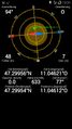
| Sun 25 May 2014 in 47,11: 47.2995598, 11.0462197 geohashing.info google osm bing/os kml crox |
Location 2 of 3 consecutive
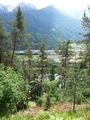
In a forest near Telfs, close to the river Inn.
Participants
- LeslieHapablap (previous|next)
- Waltraud the hashkiwi
Plans
Go there by bike, walk the very last part.
Expedition
- Towel Day! Going there by bike, starting in a few minutes. -- LeslieHapablap (talk) 04:39, 25 May 2014 (EDT)
This was a nice tour of about 60 km, almost entirely level, but my legs were still a bit sore from yesterday's expedition. I knew the route from our previous tours to Garmisch-Partenkirchen and Pettnau. On my way to the hashpoint I had some pleasant tailwind which allowed for a good pace.
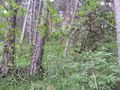
I brought additional clothes and a second pair of shoes for the walk to the hashpoint, and of course a Towel. Compared to yesterday's hash, this one was very easy to approach. Only my GPS device had some trouble picking up the signal in the woods, a distance of 7 m with large uncertainty was the best reading I could get. Still good enough to count it as "reached" any other spot nearby wouldn't have been more difficult to go.
On my way back I had the wind from up front, but luckily I could join two other road bikers and slipstreaming helped a lot.
Tracklog
Photos
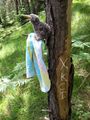
This was the best reading I could get, my device kept losing the signal...
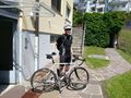
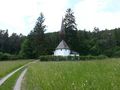
Starting the expedition.
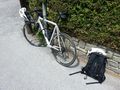
Arriving near the hash point, my bike has to wait.
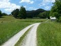
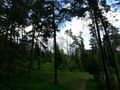
Somewhere in there...
Waltraud on Towel Day.
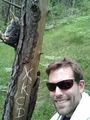
Towel Day silly grin.

Panorama of the hashpoint area.


Achievements
LeslieHapablap earned the Land geohash achievement
|
LeslieHapablap earned the Bicycle geohash achievement
|
LeslieHapablap earned the Towel Day achievement
|
LeslieHapablap earned the Consecutive geohash achievement
|