Difference between revisions of "2014-05-31 52 1"
imported>Sourcerer m ([live] Arrived.) |
imported>FippeBot m (Location) |
||
| (8 intermediate revisions by one other user not shown) | |||
| Line 1: | Line 1: | ||
| − | |||
| − | |||
| − | |||
| − | |||
| − | |||
| − | |||
| − | |||
| − | |||
| − | |||
| − | |||
{{meetup graticule | {{meetup graticule | ||
| − | | lat=52 | + | | lat=52 |
| − | | lon=1 | + | | lon=1 |
| − | | date=2014-05-31 | + | | date=2014-05-31 |
| + | | graticule_name=Norwich | ||
| + | | graticule_link=Norwich, United Kingdom | ||
}} | }} | ||
| − | |||
__NOTOC__ | __NOTOC__ | ||
| + | |||
== Location == | == Location == | ||
| − | + | ||
| + | In a small patch of woodland north of Roughton Road railway station, Cromer, Norfolk, UK. | ||
== Participants == | == Participants == | ||
| − | |||
| − | |||
| − | + | * [[User:Sourcerer|Sourcerer]] | |
| − | + | * [[User:Sourcerer|Sourcerer]] made a retro visit while going to [[2015-02-13 52 1]]. | |
== Expedition == | == Expedition == | ||
| − | |||
| + | *Arrived. -- [[User:Sourcerer|Sourcerer]] ([[User talk:Sourcerer|talk]]) [http://www.openstreetmap.org/?lat=52.91797757&lon=1.30204082&zoom=16&layers=B000FTF @52.9180,1.3020] 09:21, 31 May 2014 (EDT) | ||
| − | + | This looked reachable. The weather was OK. It was the weekend. No brainer. Go and have a look. It was easily reached up a bank covered in thorny brambles. | |
| − | + | ||
| − | + | There was one curiosity. My Garmin GPSr disagreed by 10 metres with my HTC phone GPSr. I wonder if this is because only five digits are allowed after the decimal point when setting latitude and longitude. Maybe I miss-keyed a digit. I went to both spots though so it's not a problem. | |
| + | |||
| + | The woodland tracks I used were not on Open Street Map so I added them along with an undersized soccer pitch. | ||
== Photos == | == Photos == | ||
| − | + | ||
| − | |||
| − | |||
<gallery perrow="5"> | <gallery perrow="5"> | ||
| + | |||
| + | Image:2014-05-31_52_1_14-20-53-706.jpg | [http://www.openstreetmap.org/?lat=52.91797221&lon=1.30204082&zoom=16&layers=B000FTF @52.9180,1.3020] Proof | ||
| + | Image:2014-05-31_52_1_14-22-12-127.jpg | [http://www.openstreetmap.org/?lat=52.91119085&lon=1.29317625&zoom=16&layers=B000FTF @52.9112,1.2932] Selfie | ||
| + | Image:2014-05-31_52_1_14-22-36-185.jpg | [http://www.openstreetmap.org/?lat=52.91099060&lon=1.29358440&zoom=16&layers=B000FTF @52.9110,1.2936] Terrain | ||
| + | Image:2014-05-31 52 1 OSM Grab.jpg | Open Street Map Additions | ||
</gallery> | </gallery> | ||
== Achievements == | == Achievements == | ||
| + | |||
{{#vardefine:ribbonwidth|800px}} | {{#vardefine:ribbonwidth|800px}} | ||
| − | |||
| + | {{OpenStreetMap achievement | ||
| + | | latitude = 52 | ||
| + | | longitude = 1 | ||
| + | | date = 2014-05-31 | ||
| + | | OSMlink = 22657787 | ||
| + | | name = Sourcerer | ||
| + | }} | ||
| − | + | {{Sourcerer_links | |
| − | + | | prev = 2014-05-10 52 1 | |
| − | + | | curr = 2014-05-31 52 1 | |
| − | + | | next = 2014-06-29 52 0 | |
| − | + | | date = 2014-05-31 | |
| − | + | }} | |
| − | |||
| − | |||
| − | |||
| − | |||
| − | |||
[[Category:Expeditions]] | [[Category:Expeditions]] | ||
| − | |||
[[Category:Expeditions with photos]] | [[Category:Expeditions with photos]] | ||
| − | |||
| − | |||
| − | |||
| − | |||
| − | |||
[[Category:Coordinates reached]] | [[Category:Coordinates reached]] | ||
| − | + | [[Category:Retro meetup]] | |
| − | + | [[Category:Retro coordinates reached]] | |
| − | + | {{location|GB|ENG|NFK}} | |
| − | |||
| − | |||
| − | |||
| − | |||
| − | |||
| − | |||
| − | [[Category: | ||
| − | |||
| − | |||
| − | [[Category: | ||
| − | |||
| − | |||
| − | |||
| − | |||
| − | |||
Latest revision as of 06:45, 14 August 2019
| Sat 31 May 2014 in Norwich: 52.9179713, 1.3020586 geohashing.info google osm bing/os kml crox |
Location
In a small patch of woodland north of Roughton Road railway station, Cromer, Norfolk, UK.
Participants
- Sourcerer
- Sourcerer made a retro visit while going to 2015-02-13 52 1.
Expedition
- Arrived. -- Sourcerer (talk) @52.9180,1.3020 09:21, 31 May 2014 (EDT)
This looked reachable. The weather was OK. It was the weekend. No brainer. Go and have a look. It was easily reached up a bank covered in thorny brambles.
There was one curiosity. My Garmin GPSr disagreed by 10 metres with my HTC phone GPSr. I wonder if this is because only five digits are allowed after the decimal point when setting latitude and longitude. Maybe I miss-keyed a digit. I went to both spots though so it's not a problem.
The woodland tracks I used were not on Open Street Map so I added them along with an undersized soccer pitch.
Photos
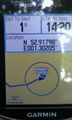
@52.9180,1.3020 Proof

@52.9112,1.2932 Selfie

@52.9110,1.2936 Terrain
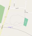
Open Street Map Additions


Achievements
Sourcerer earned the OpenStreetMap achievement
|
Expeditions and Plans
| 2014-05-31 | ||
|---|---|---|
| Atlanta, Georgia | NWoodruff | In the back yard area of an apartment complex in Chamblee |
| Eugene, Oregon | Michael5000 | The front yard of a vacant house on Miller Street in Dallas. |
| Zürich, Switzerland | RecentlyChanged, as much friends he possibly can | Really deep in the forrest, even for a native like I am. No good way to get... |
| Mannheim, Germany | DODO | On a field near Bodenheim. |
| Schweinfurt, Germany | GeorgDerReisende | The hash lies on a meadow in Wilhelmsthal near Eisenach. |
| Erfurt, Germany | Jens, Räbe | In a meadow near Hetschburg. |
| Norwich, United Kingdom | Sourcerer | In a small patch of woodland north of Roughton Road railway station, Cromer... |
| København, Denmark | j0e | Forest area surrounding Salpetermosen (The Saltpeter Bog) outside Hillerød |
Sourcerer's Expedition Links
2014-05-10 52 1 - 2014-05-31 52 1 - 2014-06-29 52 0 - KML file download of Sourcerer's expeditions for use with Google Earth.