Difference between revisions of "2014-07-10 global"
imported>Rex Wolf (Uploaded expedition report. Photos to come soon!) |
imported>Rex Wolf (Added photos and tracklog.) |
||
| Line 74: | Line 74: | ||
== Tracklog == | == Tracklog == | ||
<!-- if your GPS device keeps a log, you may post a link here --> | <!-- if your GPS device keeps a log, you may post a link here --> | ||
| + | [[:Image:Rex-Global-2014-07-10-tracklog.png|Rex's tracklog as PNG.]] | ||
== Photos == | == Photos == | ||
| Line 79: | Line 80: | ||
Image:2009-##-## ## ## Alpha.jpg | Witty Comment | Image:2009-##-## ## ## Alpha.jpg | Witty Comment | ||
--> | --> | ||
| − | |||
<gallery perrow="5"> | <gallery perrow="5"> | ||
| + | Image:Rex-Global-2014-07-10-1.JPG | The plasticized pilot's map. | ||
| + | Image:Rex-Global-2014-07-10-2.JPG | The river as we take off. | ||
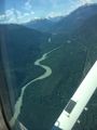
| + | Image:Rex-Global-2014-07-10-3.JPG | A view of Squamish. | ||
| + | Image:Rex-Global-2014-07-10-4.JPG | More of Squamish. | ||
| + | Image:Rex-Global-2014-07-10-5.JPG | Mount Garabaldi. | ||
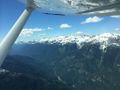
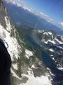
| + | Image:Rex-Global-2014-07-10-6.JPG | The mountains further up the valley. | ||
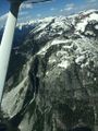
| + | Image:Rex-Global-2014-07-10-7.JPG | The Rumbling Glacier is behind these guys. | ||
| + | Image:Rex-Global-2014-07-10-8.JPG | Further down the valley. | ||
| + | Image:Rex-Global-2014-07-10-9.JPG | A small valley leading up towards the Rumbling Glacier. | ||
| + | Image:Rex-Global-2014-07-10-10.JPG | A small mountain lake, cupped in the high ridge. | ||
| + | Image:Rex-Global-2014-07-10-11.JPG | A slight detour towards the Rumbling Glacier. | ||
| + | Image:Rex-Global-2014-07-10-12.JPG | Getting closer to the Glacier. | ||
| + | Image:Rex-Global-2014-07-10-13.JPG | One valley near, one valley far. | ||
| + | Image:Rex-Global-2014-07-10-14.JPG | Even closer to the Glacier! | ||
| + | Image:Rex-Global-2014-07-10-15.JPG | Another valley view. | ||
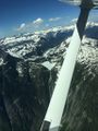
| + | Image:Rex-Global-2014-07-10-16.JPG | Crossing over into mountainous terrain. | ||
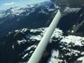
| + | Image:Rex-Global-2014-07-10-17.JPG | Leaving the valley on our wing. | ||
| + | Image:Rex-Global-2014-07-10-18.JPG | It's all mountains ahead. | ||
| + | Image:Rex-Global-2014-07-10-19.JPG | We thought the hashpont was here at first. | ||
| + | Image:Rex-Global-2014-07-10-20.JPG | There's the two frozen lakes! | ||
| + | Image:Rex-Global-2014-07-10-21.JPG | Coming further around to our right. | ||
| + | Image:Rex-Global-2014-07-10-22.JPG | The hashpoint is down there somewhere... | ||
| + | Image:Rex-Global-2014-07-10-23.PNG | Coordinates! | ||
| + | Image:Rex-Global-2014-07-10-24.JPG | This lake had some logging roads along it, and what looked like a dock... | ||
| + | Image:Rex-Global-2014-07-10-25.JPG | Better view of the dock area. | ||
| + | Image:Rex-Global-2014-07-10-26.JPG | The far end of that lake takes a sudden tumble... | ||
| + | Image:Rex-Global-2014-07-10-27.JPG | Approaching Mount Tantalus on the far right. | ||
| + | Image:Rex-Global-2014-07-10-28.JPG | Logging roads around the foot of Tantalus. | ||
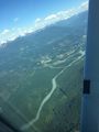
| + | Image:Rex-Global-2014-07-10-29.JPG | A view further down the valley. | ||
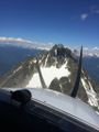
| + | Image:Rex-Global-2014-07-10-30.JPG | Tantalus also has the Witch's Tooth, a small projection in between the two peaks. | ||
| + | Image:Rex-Global-2014-07-10-31.JPG | A more contrasting view of the Witch's Tooth. | ||
| + | Image:Rex-Global-2014-07-10-32.JPG | These mountain lakes are really quite pretty. | ||
| + | Image:Rex-Global-2014-07-10-33.JPG | So are the mountains. | ||
| + | Image:Rex-Global-2014-07-10-34.JPG | And we got fairly close to them! | ||
| + | Image:Rex-Global-2014-07-10-35.JPG | Coming around the side of Mount Tantalus. | ||
| + | Image:Rex-Global-2014-07-10-36.JPG | Lake Lovelywater. | ||
| + | Image:Rex-Global-2014-07-10-37.JPG | And Squamish just behind it. | ||
| + | Image:Rex-Global-2014-07-10-38.JPG | Bye bye, mountains! | ||
| + | Image:Rex-Global-2014-07-10-39.JPG | Coming back down into the Squamish area. | ||
| + | Image:Rex-Global-2014-07-10-40.JPG | River and town. | ||
| + | Image:Rex-Global-2014-07-10-41.JPG | More town. | ||
| + | Image:Rex-Global-2014-07-10-42.JPG | And over it all, Mount Garabaldi. | ||
| + | Image:Rex-Global-2014-07-10-43.JPG | On final approach to the landing strip, a switching station! | ||
| + | Image:Rex-Global-2014-07-10-44.JPG | And its partner. | ||
| + | Image:Rex-Global-2014-07-10-45.JPG | Two hashers, a pilot, and a plane. | ||
</gallery> | </gallery> | ||
| Line 89: | Line 134: | ||
| date = 2014-07-10 | | date = 2014-07-10 | ||
| name = [[User:Rex Wolf|Rex]] and [[User:OtherJack|OtherJack]] | | name = [[User:Rex Wolf|Rex]] and [[User:OtherJack|OtherJack]] | ||
| − | + | | image = Rex-Global-2014-07-10-45.JPG | |
| vehicle = Cessna 172 | | vehicle = Cessna 172 | ||
| subcategory = Mile High | | subcategory = Mile High | ||
| Line 97: | Line 142: | ||
| date = 2014-07-10 | | date = 2014-07-10 | ||
| name = [[User:Rex Wolf|Rex]] and [[User:OtherJack|OtherJack]] | | name = [[User:Rex Wolf|Rex]] and [[User:OtherJack|OtherJack]] | ||
| − | + | | image = Rex-Global-2014-07-10-45.JPG | |
}} | }} | ||
| Line 106: | Line 151: | ||
| partner = Steve the pilot | | partner = Steve the pilot | ||
| name = [[User:Rex Wolf|Rex]] and [[User:OtherJack|OtherJack]] | | name = [[User:Rex Wolf|Rex]] and [[User:OtherJack|OtherJack]] | ||
| − | + | | image = Rex-Global-2014-07-10-45.JPG | |
}} | }} | ||
Revision as of 22:08, 13 July 2014
|
Globalhash on Thu 10 Jul 2014: |
|
Thu Jul 10 2014 Globalhash: |
Location
South of Tzoonie Lake, between Serov and Vrubel Peaks.
Participants
Plans
- We are going for it! 3:30 ish custom sightseeing flight ... they seem to like the idea of geohashing, too. -- OtherJack (talk) 14:59, 10 July 2014 (EDT) -- OtherJack (talk) 14:59, 10 July 2014 (EDT)
Expedition
OtherJack
Lots to come. I am going to sleep now. Kudos to Srs0 for the idea... -- OtherJack (talk) 03:26, 11 July 2014 (EDT)
Rex
I left work around 1:20PM, given that Jack had texted me and said they were running a little early. Getting to Pacific Central Station was no problem, as I've done that drive many times. Upon arrival, I parked and waited quietly for Jack's bus to arrive. Given the placement of his bus's gate, I wasn't sure if he would walk inside, or follow the walkway out to the front of the building, so I kept walking back and forth between those locations to make sure I wasn't missing him. Chatted to a friendly Greyhound guy who was out front having a smoke. He said he'd let me in, but I'd have to go through security. I didn't mind having to wait out front.
As it happened, I was in the right place at the right time, as I'd gone into the station and then stood just inside the security screening area (where there was nobody on duty) as Jack's bus arrived. We spotted each other and quickly proceeded into the station, and then out to my car.
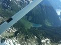
Downtown Vancouver wasn't bad, but as we hit Stanley Park, traffic slowed to a crawl. The fire truck and ambulance that passed us made me guess that there was an accident ahead. The local traffic news confirmed that, but at least the traffic wasn't blocking our side of the road. So it took some time for us to make it back out to the highway. But once we did, we made excellent time along Highway 1 and then up the Sea-to-Sky Highway.
(I mentioned to Jack that, before the highway was improved for the 2010 Winter Olympics, the local story about that highway said that the name was given because after your car fell off the side, you'd go to the sea, and then to the sky. Hopefully with a new pair of wings and a halo to match.)
Google's driving directions seemed a little odd, a couple times. We'd be driving along the highway northbound, and Google would suddenly announce that in so-many meters, we'd be merging on to the same highway...southbound. We'd drive on the "southbound" highway for another couple kilometers before Google announced that we were now merging on to the "northbound" highway. Jack suspected my GPS was screwing up, but I noticed that, in at least one place, the announced name of the highway changed. I wondered if that had anything to do with the screwy directions.
We actually arrived two minutes before we were due at Sea-to-Sky Air. We went inside and started figuring out where we were really wanting to go. Jack had provided the coordinates over the phone, but they explained that it took them a while to figure out what he'd meant. At which point they kindly explained to us that "there's no such thing as 'negative degrees.'" At which point we realized that they needed coordinates in the degrees, minutes, and seconds format. (They also measure distance in nautical miles and height in thousands of feet.) I helpfully tried to provide degrees, minutes, and decimal minutes, before Jack pointed out that the decimal minutes were not equivalent to actual seconds.
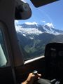
I did find the correct DMS on my display, after another minute, but it was moot by then--Jack had everything sorted out and written down. So Steve (our pilot) and we went to the planning computer and worked on figuring out where the coordinates actually were. Steve estimated it would be about a 40-minute round-trip, and outlined the course he was expecting us to take. He also outlined a shortcut that we could take, if we got enough altitude to do it. He marked it down on a plasticized flight map, and we headed outside.
Steve took us to a Cessna 172 to start the safety briefing. (I forget the tail number, but it was Charlie blank Whiskey Kilo Charlie--probably the plane in this photograph.) In our case, the safety briefing was limited to seatbelt, fire extinguisher, first aid kit, survival kit, barf bags, and a warning about opening the windows during flight to take better pictures. Dropping one's phone because the slipstream ripped it out of your hand would be highly annoying.
Jack had the whole back seat to himself, and I sat up front with Steve. Headsets all round, and then it was out to the runway. There was a fairly heavy crosswind, so our takeoff was somewhat wobbly--it's always fascinating and a little eery to get a foot off the ground, and suddenly have your nose pointed at an angle to your direction of flight, with the wings wanting to flip over in the wind. But Steve's got skillz, yo!
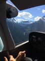
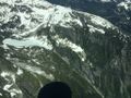
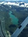
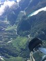
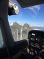
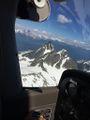
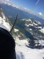
Those skills were on display, as we turned around and headed up through the valleys, gaining altitude as we went. Steve apparently teaches courses on mountain flying, and he noted the strong updrafts we were getting off the mountains today were helping us gain altitude much more rapidly than we otherwise could. He showed off the Rumbling Glacier to us on our way in, and that was quite the sight. More than that, I was fascinated by the little lakes that I could spot cupped in the big mountain ranges and foothills in the area. Far above the valley below, but there they were.
We did gain altitude quickly enough to take our direct shortcut route, and Steve was looking for a pair of lakes near the hashpoint. He thought he'd found them, but I really wasn't confident. My GPS said we still had another 8 kilometers or so to go. Jack was going back and forth with Steve over the intercom, working on directions, but I eventually just held up my phone so Steve could get a better idea of where we were.
(Before leaving on the expedition, I downloaded the full terrain maps for the area into my GPS app--I didn't want to be trying to download maps while in flight over a cellular connection. So I had the hashpoint set as the destination, terrain maps available, and was not only recording our track, but watching it update live every three seconds or so.)
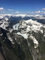
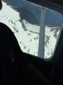
Steve took one look at my phone and went "Hey, that's really cool!" And promptly adjusted our flight heading. As we went a little further, he realized that the pair of lakes we were looking for were ahead, around another peak. I caught sight of them too--the smaller one was iced over with snow, and the large one had only a tiny sliver of water in the middle, with ice and snow covering the rest of it. Jack couldn't identify the lakes at first until he too realized that they were iced over.
We curved around the hashpoint in a gentle arc, and I kept monitoring our progress. We weren't really close to the hash, but it was probably as good as we were going to get. Again, Steve wasn't entirely sure where we needed to be, since he didn't have a GPS in the plane. So I handed him mine. He looked at it, saw our track, and brought us around. Then the bank steepened, and for a moment I thought something must be wrong--we hadn't banked at that angle the entire flight. But I realized Steve was just bringing us around in a tighter curve to head for the hashpoint. And he was almost dead-on! A slight correction later, and we were headed right down the bearing like our nose was on a wire!
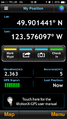
I tried to capture our coordinates at the right moment, but they updated a split second before I got my screen capture. Jack happily announced that his GPS recorded us being only 32 feet away from the hashpoint. In an airplane, I'd call that good enough--it's well within the 10m margin of error I often suffer on the ground. We were around 7500-8000 feet altitude at the time. I saved our track and put the GPS away. Right afterwards, Steve had to check his map and altimeter to make sure we weren't violating Vancouver airspace, but we were fine.
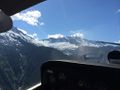
On the way back, Steve showed us some more landmarks, like the Witch's Tooth, Mount Garibaldi, Mount Tantalus, its twin peak Dijon, and Lake Lovelywater. He also pointed out some hunting cabins and lodges on the mountains and lake shores along the way. I kept taking pictures like nobody's business.
Losing altitude to come back in was harder than gaining altitude had been, and we had to circle a bit. Steve tried to bring us down nice and gentle for our ears. I was having trouble with my left ear, but oddly enough, the gentler and slower Steve brought us down, the more annoyed my ears became. Speeding up our rate of descent cleared everything up. I guess I'm just weird.
We landed, took a picture of all of us with the plane, and went in to clear up the bill. Then, with Steve's recommendation, we stopped by a food truck on the way back. The Locavore had some damn fine food! Jack had half a rotisserie chicken with roasted potatoes, and I had a pork Banh Mi in a pita, with bacon, with roasted potatoes. Oh man, that was TASTY!
After that, it was just back down to Vancouver. Traffic across the Lion's Gate was terrible, as usual. With some extra time, I also took Jack to La Casa Gelato. He had a passion fruit sorbetto, while I enjoyed some garlic ice cream, maple bacon ice cream, and apple cheddar ice cream. Perfect capper on the afternoon, I'd say!
Tracklog
Photos
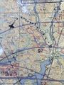
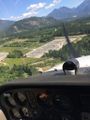
The plasticized pilot's map.
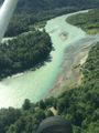
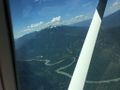
The river as we take off.
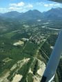
A view of Squamish.
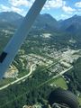
More of Squamish.
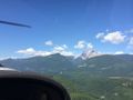
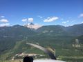
Mount Garabaldi.
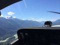
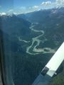
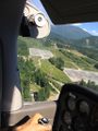
The mountains further up the valley.
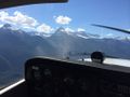
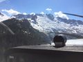
The Rumbling Glacier is behind these guys.
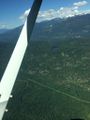
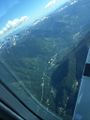
Further down the valley.
A small valley leading up towards the Rumbling Glacier.
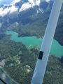
A small mountain lake, cupped in the high ridge.
A slight detour towards the Rumbling Glacier.
Getting closer to the Glacier.
One valley near, one valley far.
Even closer to the Glacier!
Another valley view.
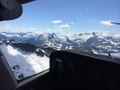
Crossing over into mountainous terrain.
Leaving the valley on our wing.
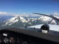
It's all mountains ahead.
We thought the hashpont was here at first.
There's the two frozen lakes!
Coming further around to our right.
The hashpoint is down there somewhere...
Coordinates!
This lake had some logging roads along it, and what looked like a dock...
Better view of the dock area.
The far end of that lake takes a sudden tumble...
Approaching Mount Tantalus on the far right.
Logging roads around the foot of Tantalus.
A view further down the valley.
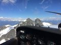
Tantalus also has the Witch's Tooth, a small projection in between the two peaks.
A more contrasting view of the Witch's Tooth.
These mountain lakes are really quite pretty.
So are the mountains.
And we got fairly close to them!
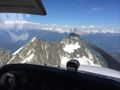
Coming around the side of Mount Tantalus.
Lake Lovelywater.
And Squamish just behind it.
Bye bye, mountains!
Coming back down into the Squamish area.
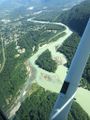
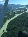
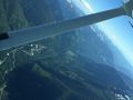
River and town.
More town.
And over it all, Mount Garabaldi.
On final approach to the landing strip, a switching station!
And its partner.
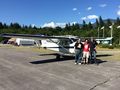
Two hashers, a pilot, and a plane.


Achievements
Rex and OtherJack earned the Air geohash achievement
|
Rex and OtherJack earned the Globalhash achievement
|
Rex and OtherJack earned the Drag-along achievement
|