Difference between revisions of "2015-01-19 50 0"
imported>Sourcerer (→Planning 1 of 7) |
imported>FippeBot m (Location) |
||
| (17 intermediate revisions by one other user not shown) | |||
| Line 1: | Line 1: | ||
| − | |||
| − | |||
| − | |||
| − | |||
| − | |||
| − | |||
| − | |||
| − | |||
| − | |||
| − | |||
{{meetup graticule | {{meetup graticule | ||
| lat=50 | | lat=50 | ||
| lon=0 | | lon=0 | ||
| date=2015-01-19 | | date=2015-01-19 | ||
| + | | graticule_name=Eastbourne, UK | ||
| + | | graticule_link=Eastbourne, United Kingdom | ||
}} | }} | ||
| − | |||
| − | |||
__NOTOC__ | __NOTOC__ | ||
== Location == | == Location == | ||
| − | + | ||
| + | 1) South east of a sewage works in a hard-frozen field, Newick, East Sussex, UK. | ||
== Participants == | == Participants == | ||
| − | + | ||
| − | + | [[User:Sourcerer|Sourcerer]] | |
== Plans == | == Plans == | ||
| − | + | ||
| + | If successful, this will be hashpoint 1 of 7 today. --[[User:Sourcerer|Sourcerer]] ([[User talk:Sourcerer|talk]]) 10:21, 18 January 2015 (EST) | ||
| + | |||
| + | [[2015-01-19_50_0]] :: [[2015-01-19_50_-0]] :: [[2015-01-19_50_-1]] :: [[2015-01-19_51_-0]] :: [[2015-01-19_51_0]] :: [[2015-01-19_52_-0]] :: [[2015-01-19_52_0]] | ||
== Expedition == | == Expedition == | ||
| − | |||
| − | == | + | *Arrived. -- [[User:Sourcerer|Sourcerer]] ([[User talk:Sourcerer|talk]]) [http://www.openstreetmap.org/?lat=50.97728670&lon=.02529323&zoom=16&layers=B000FTF @50.9773,.0253] 06:45, 19 January 2015 (GMT) |
| − | + | ||
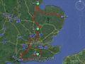
| + | On Monday January 19th Sourcerer set out at 3am, drove 546 miles and attempted seven hashpoints in about 16 hours. Six were reached. This was the first success. | ||
| + | |||
| + | My Christmas present, a Tesco Hudl Android tablet running NavFree satnav, got me to the parking place with no errors. The return walk to the hashpoint was just under 1 km. There was a service road leading to the sewage works which I added to Openstreetmap. Then there was a walk along the field perimeter, in pitch dark, over hard frozen terrain. My hash-bitch (Lyla) loved this. | ||
| + | |||
| + | == Photos == | ||
| − | |||
| − | |||
| − | |||
| − | |||
<gallery perrow="5"> | <gallery perrow="5"> | ||
| + | Image:2015-01-19-Sourcerer.jpg | Overview | ||
| + | Image:2015-01-19_50_0_Sourcerer_1.jpg | Track Log | ||
| + | Image:2015-01-19_50_0_Sourcerer_2.jpg | Evidence | ||
| + | Image:2015-01-19_50_-0_Sourcerer_2.jpg | Frozen Hash Bitch | ||
</gallery> | </gallery> | ||
== Achievements == | == Achievements == | ||
{{#vardefine:ribbonwidth|800px}} | {{#vardefine:ribbonwidth|800px}} | ||
| − | |||
| + | {{Frozen Geohash | ||
| + | | latitude = 50 | ||
| + | | longitude = 0 | ||
| + | | date = 2015-01-19 | ||
| + | | temperature = -1C | ||
| + | | name = Sourcerer | ||
| + | }} | ||
| + | {{OpenStreetMap achievement | ||
| + | | latitude = 50 | ||
| + | | longitude = 0 | ||
| + | | date = 2015-01-19 | ||
| + | | OSMlink = 28268210 | ||
| + | | name = Sourcerer | ||
| + | }} | ||
| + | {{Minesweeper geohash | ||
| + | | graticule = Eastbourne, United Kingdom | ||
| + | | ranknumber = 3 | ||
| + | | n = true | ||
| + | | ne = true | ||
| + | | nw = true | ||
| + | | name = Sourcerer | ||
| + | }} | ||
| + | {{Minesweeper geohash | ||
| + | | graticule = Canterbury,_United_Kingdom | ||
| + | | ranknumber = 4 | ||
| + | | n = true | ||
| + | | nw = true | ||
| + | | sw = true | ||
| + | | w = true | ||
| + | | name = Sourcerer | ||
| + | }} | ||
| + | {{Minesweeper geohash | ||
| + | | graticule = London_East,_United_Kingdom | ||
| + | | ranknumber = 6 | ||
| + | | n = true | ||
| + | | ne = true | ||
| + | | nw = true | ||
| + | | w = true | ||
| + | | e = true | ||
| + | | s = true | ||
| + | | name = Sourcerer | ||
| + | }} | ||
| + | {{Minesweeper geohash | ||
| + | | graticule = London_West,_United_Kingdom | ||
| + | | ranknumber = 6 | ||
| + | | n = true | ||
| + | | ne = true | ||
| + | | nw = true | ||
| + | | w = true | ||
| + | | e = true | ||
| + | | se = true | ||
| + | | name = Sourcerer | ||
| + | }} | ||
| − | + | {{Sourcerer_links | |
| − | + | | prev = 2015-01-18 52 1 | |
| − | + | | curr = 2015-01-19 50 0 | |
| − | + | | next = 2015-01-19 50 -0 | |
| − | + | | date = 2015-01-19 | |
| + | }} | ||
| − | |||
| − | |||
| − | |||
| − | |||
| − | |||
| − | |||
[[Category:Expeditions]] | [[Category:Expeditions]] | ||
| − | |||
[[Category:Expeditions with photos]] | [[Category:Expeditions with photos]] | ||
| − | |||
| − | |||
| − | |||
| − | |||
| − | |||
[[Category:Coordinates reached]] | [[Category:Coordinates reached]] | ||
| − | + | [[Category:Expeditions with dogs]] | |
| − | + | {{location|GB|ENG|ESX}} | |
| − | |||
| − | [[Category: | ||
| − | |||
| − | |||
| − | |||
| − | |||
| − | |||
| − | |||
| − | |||
| − | |||
| − | |||
| − | |||
| − | |||
| − | |||
| − | |||
| − | |||
Latest revision as of 02:28, 15 August 2019
| Mon 19 Jan 2015 in Eastbourne, UK: 50.9772974, 0.0252522 geohashing.info google osm bing/os kml crox |
Location
1) South east of a sewage works in a hard-frozen field, Newick, East Sussex, UK.
Participants
Plans
If successful, this will be hashpoint 1 of 7 today. --Sourcerer (talk) 10:21, 18 January 2015 (EST)
2015-01-19_50_0 :: 2015-01-19_50_-0 :: 2015-01-19_50_-1 :: 2015-01-19_51_-0 :: 2015-01-19_51_0 :: 2015-01-19_52_-0 :: 2015-01-19_52_0
Expedition
- Arrived. -- Sourcerer (talk) @50.9773,.0253 06:45, 19 January 2015 (GMT)
On Monday January 19th Sourcerer set out at 3am, drove 546 miles and attempted seven hashpoints in about 16 hours. Six were reached. This was the first success.
My Christmas present, a Tesco Hudl Android tablet running NavFree satnav, got me to the parking place with no errors. The return walk to the hashpoint was just under 1 km. There was a service road leading to the sewage works which I added to Openstreetmap. Then there was a walk along the field perimeter, in pitch dark, over hard frozen terrain. My hash-bitch (Lyla) loved this.
Photos
Overview
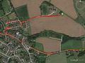
Track Log

Evidence

Frozen Hash Bitch


Achievements

Sourcerer earned the OpenStreetMap achievement
|
Sourcerer achieved level 3 of the Minesweeper Geohash achievement
|
Sourcerer achieved level 4 of the Minesweeper Geohash achievement
|
Sourcerer achieved level 6 of the Minesweeper Geohash achievement
|
Sourcerer achieved level 6 of the Minesweeper Geohash achievement
|
Expeditions and Plans
| 2015-01-19 | ||
|---|---|---|
| Atlanta, Georgia | NWoodruff | On the playground of an elementary school in Lawrenceville. |
| Jacksonville, Illinois | Mystrsyko, Dolphintreasure | In a field near Cox Creek, north of Ashland, IL. |
| Newark, New Jersey | OtherJack, Jevanyn | Back of someone's house in Emerson. |
| Brighton, United Kingdom | Sourcerer | 2) On deep frozen common heath-land north of North Chailey, East Sussex, UK... |
| Southampton, United Kingdom | Sourcerer | 3) Behind live-stock grade hedges, fences and gates, south of East Meon, Ha... |
| Eastbourne, United Kingdom | Sourcerer | 1) South east of a sewage works in a hard-frozen field, Newick, East Sussex... |
| Erfurt, Germany | FeepingCreature | Hash is in a parking lot in the town center of Erfurt. Extremely reachable.... |
| London West, United Kingdom | Sourcerer | 4) In a field of winter wheat, east of the A10 trunk road, between Buckland... |
| London East, United Kingdom | Sourcerer | 5) In a field of winter wheat, west of Anstey and a quarry, Hertfordshire, ... |
| Northampton, United Kingdom | Sourcerer | 6) A double pub geohash beside the River Witham in the middle of Boston, Li... |
| Cambridge, United Kingdom | Sourcerer | 7) In a muddy field, east of Boston, Lincolnshire, UK. |
Sourcerer's Expedition Links
2015-01-18 52 1 - 2015-01-19 50 0 - 2015-01-19 50 -0 - KML file download of Sourcerer's expeditions for use with Google Earth.