Difference between revisions of "2015-10-16 52 -0"
imported>Sourcerer m ([live picture] Proof. [http://www.openstreetmap.org/?lat=52.24858940&lon=-.08193612&zoom=16&layers=B000FTF @52.2486,-.0819]) |
imported>FippeBot m (Location) |
||
| (6 intermediate revisions by one other user not shown) | |||
| Line 3: | Line 3: | ||
| lon=-0 | | lon=-0 | ||
| date=2015-10-16 | | date=2015-10-16 | ||
| + | | graticule_name=Northampton, UK | ||
| + | | graticule_link=Northampton, United Kingdom | ||
}} | }} | ||
__NOTOC__ | __NOTOC__ | ||
| − | |||
== Location == | == Location == | ||
| − | In a field south west of Elsworth, Cambridgeshire, UK. | + | 4) In a field south west of Elsworth, Cambridgeshire, UK. |
== Participants == | == Participants == | ||
| Line 22: | Line 23: | ||
== Expedition == | == Expedition == | ||
| + | *Arrived. -- [[User:Sourcerer|Sourcerer]] ([[User talk:Sourcerer|talk]]) [http://www.openstreetmap.org/?lat=52.24858940&lon=-.08193612&zoom=16&layers=B000FTF @52.2486,-.0819] 00:08, 16 October 2015 (GMT+01:00) | ||
| + | This was routine but damp. The evening had been mostly dry but the heavens opened for my walk to this hashpoint. It was wind-blown fine rain which is particularly effective at wetting. I followed a public footpath which was actually a gravel and later a concrete farm access road. Near the hashpoint, I crossed a newly cultivated field with no new growth showing. I arrived 8 minutes behind schedule. Later, back at the car, I had small problems with steam clouding my windows. With the blowers on max, I dried out over the next hour. | ||
| − | |||
| − | |||
== Photos == | == Photos == | ||
<gallery> | <gallery> | ||
| − | |||
Image:2015-10-16_52_-0_Sourcerer_1444950489184.jpg | Proof. [http://www.openstreetmap.org/?lat=52.24858940&lon=-.08193612&zoom=16&layers=B000FTF @52.2486,-.0819] | Image:2015-10-16_52_-0_Sourcerer_1444950489184.jpg | Proof. [http://www.openstreetmap.org/?lat=52.24858940&lon=-.08193612&zoom=16&layers=B000FTF @52.2486,-.0819] | ||
| + | Image:2015-10-16_52_-0_Sourcerer.jpg | Track in Google Earth | ||
</gallery> | </gallery> | ||
== Achievements == | == Achievements == | ||
{{#vardefine:ribbonwidth|700px}} | {{#vardefine:ribbonwidth|700px}} | ||
| + | |||
| + | {{Midnight geohash | ||
| + | | latitude = 52 | ||
| + | | longitude = -0 | ||
| + | | date = 2015-10-16 | ||
| + | | name = Sourcerer | ||
| + | }} | ||
{{Sourcerer_links | {{Sourcerer_links | ||
| Line 42: | Line 50: | ||
}} | }} | ||
| − | |||
| − | |||
[[Category:Expeditions]] | [[Category:Expeditions]] | ||
[[Category:Expeditions with photos]] | [[Category:Expeditions with photos]] | ||
[[Category:Coordinates reached]] | [[Category:Coordinates reached]] | ||
| − | + | {{location|GB|ENG|CAM}} | |
Latest revision as of 05:27, 15 August 2019
| Fri 16 Oct 2015 in Northampton, UK: 52.2485925, -0.0818851 geohashing.info google osm bing/os kml crox |
Location
4) In a field south west of Elsworth, Cambridgeshire, UK.
Participants
Plans
Expedition four of six spanning midnight.
2015-10-15 52 1 - 2015-10-15 52 0 - 2015-10-15 52 -0 - 2015-10-16 52 -0 - 2015-10-16 52 0 - 2015-10-16 52 1 - ETA 00:00.
Expedition
- Arrived. -- Sourcerer (talk) @52.2486,-.0819 00:08, 16 October 2015 (GMT+01:00)
This was routine but damp. The evening had been mostly dry but the heavens opened for my walk to this hashpoint. It was wind-blown fine rain which is particularly effective at wetting. I followed a public footpath which was actually a gravel and later a concrete farm access road. Near the hashpoint, I crossed a newly cultivated field with no new growth showing. I arrived 8 minutes behind schedule. Later, back at the car, I had small problems with steam clouding my windows. With the blowers on max, I dried out over the next hour.
Photos
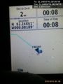
Proof. @52.2486,-.0819
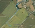
Track in Google Earth


Achievements
Sourcerer earned the Midnight Geohash achievement
|
Expeditions and Plans
| 2015-10-16 | ||
|---|---|---|
| Northampton, United Kingdom | Sourcerer | 4) In a field south west of Elsworth, Cambridgeshire, UK. |
| Cambridge, United Kingdom | Sourcerer, Benjw, Tongs/B | 5) A road hashpoint between Oakington and Girton, Cambridgeshire, UK. |
| Norwich, United Kingdom | Sourcerer | 6) In the middle of Freelands (road), Mendlesham, Suffolk, UK - no need to ... |
Sourcerer's Expedition Links
2015-10-15 52 -0 - 2015-10-16 52 -0 - 2015-10-16 52 0 - KML file download of Sourcerer's expeditions for use with Google Earth.