Difference between revisions of "2015-11-11 52 1"
From Geohashing
imported>Sourcerer m ([live picture] Proof. [http://www.openstreetmap.org/?lat=52.68944263&lon=1.15604818&zoom=16&layers=B000FTF @52.6894,1.1560]) |
imported>Sourcerer m (→Achievements) |
||
| Line 50: | Line 50: | ||
}} | }} | ||
| − | |||
| − | |||
[[Category:Expeditions]] | [[Category:Expeditions]] | ||
[[Category:Expeditions with photos]] | [[Category:Expeditions with photos]] | ||
[[Category:Coordinates reached]] | [[Category:Coordinates reached]] | ||
| − | |||
Revision as of 00:13, 11 November 2015
| Wed 11 Nov 2015 in 52,1: 52.6894432, 1.1561064 geohashing.info google osm bing/os kml crox |
Location
In a field north of Ringland, Norfolk, UK.
Participants
Plans
Expedition two of two spanning midnight - 2015-11-10 52 1 - 2015-11-11 52 1 - ETA 00:00.
This is on a field margin close to a public footpath.
Expedition
- Arrived. -- Sourcerer (talk) @52.6895,1.1561 00:09, 11 November 2015 (GMT)
Photos
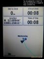
Proof. @52.6894,1.1560

Achievements
Sourcerer earned the OpenStreetMap achievement
|
Expeditions and Plans
| 2015-11-11 | ||
|---|---|---|
| St. Gallen, Switzerland | Lysogeny | In a bush by a ditch in Konstanz, Germany. |
| Stuttgart, Germany | Steingesicht | Leinfelden-Echterdingen, Hainbuchenweg - a nice pedestrian and bicycle way.... |
| London East, United Kingdom | Flicky | In a field east of Epping in Essex. |
| Norwich, United Kingdom | Sourcerer | In a field north of Ringland, Norfolk, UK. |
Sourcerer's Expedition Links
2015-11-10 52 1 - 2015-11-11 52 1 - 2015-11-12 52 1 - KML file download of Sourcerer's expeditions for use with Google Earth.