2015-11-12 52 0
| Thu 12 Nov 2015 in 52,0: 52.6691404, 0.8565536 geohashing.info google osm bing/os kml crox |
Location
A road hashpoint south of the A47 near Wendling, Norfolk, UK.
Participants
Neither knew the other was planning it.
Plans
Expedition one of two spanning midnight - 2015-11-12 52 0 - 2015-11-13 52 1 - ETA 23:15.
Expedition
- Arrived. -- Sourcerer (talk) @52.6691,.8565 23:08, 12 November 2015 (GMT)
Easy - no need to get out of the car!
This was a partly-opportunistic, partly-lazy GeoHash for MagicIan as he was due to be driving along the A47 anyway, so it was just a case of taking a 5 minute diversion to reach the hashpoint.
MagicIan got out of the car to get as close as possible to the coordinates using the droid app and to take photos, then turned the car around and went back through the hashpoint at 60mph to gain the Speed Racer achievement.
Photos
Proof. @52.6691,.8565
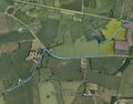
Track in Google Earth
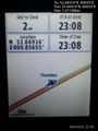
Screenshot of the Geohash Droid app showing my proximity to the hashpoint for Thursday 12-11-2015, 52.6691404°, 0.8565536° (Cambridge, United Kingdom)
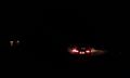
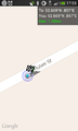
Photo taken of MagicIan's car taken from the hashpoint for Thursday 12-11-2015, 52.6691404°, 0.8565536° (Cambridge, United Kingdom)

Photo of car speedo taken driving (approximately) through the hashpoint for Thursday 12-11-2015, 52.6691404°, 0.8565536° (Cambridge, United Kingdom)


Achievements
Expeditions and Plans
| 2015-11-12 | ||
|---|---|---|
| Colac, Australia | Benjamin Kaiser | Behind a holiday house in Kennett River (between Lorne and Apollo Bay) |
| Bern, Switzerland | Brocorb | A field near Wilderswil, close to the brewery Rugenbräu. |
| Zürich, Switzerland | Someone went | Hillside forest by Stein am Rhein, Switzerland |
| Cambridge, United Kingdom | Sourcerer, MagicIan | A road hashpoint south of the A47 near Wendling, Norfolk, UK. |
Sourcerer's Expedition Links
2015-11-11 52 1 - 2015-11-12 52 0 - 2015-11-13 52 1 - KML file download of Sourcerer's expeditions for use with Google Earth.
