Difference between revisions of "2015-11-25 52 0"
imported>Sourcerer m (→Plans) |
imported>Sourcerer m (→New expedition) |
||
| Line 20: | Line 20: | ||
== Expedition == | == Expedition == | ||
| + | *Arrived. -- [[User:Sourcerer|Sourcerer]] ([[User talk:Sourcerer|talk]]) [http://www.openstreetmap.org/?lat=52.27922559&lon=.58440506&zoom=16&layers=B000FTF @52.2792,.5844] 22:26, 25 November 2015 (GMT) | ||
| + | In clear bright moonlight the expedition followed a public footpath for about half the route. On similar farm tracks but off the right of way, the distance dropped to 360 metres. A field perimeter track with game bird feeders led closer. The final approach was on tractor tracks which also served to get back to the farm track. A large flock of partridges took flight on my return walk. The round trip distance was 3.6 km. Very nice! I added the rights of way to OpenStreetMap. | ||
| − | |||
| − | |||
== Photos == | == Photos == | ||
<gallery> | <gallery> | ||
| − | |||
Image:2015-11-25_52_0_Sourcerer_1448490308279.jpg | Proof. [http://www.openstreetmap.org/?lat=52.27927923&lon=.58437824&zoom=16&layers=B000FTF @52.2793,.5844] | Image:2015-11-25_52_0_Sourcerer_1448490308279.jpg | Proof. [http://www.openstreetmap.org/?lat=52.27927923&lon=.58437824&zoom=16&layers=B000FTF @52.2793,.5844] | ||
| + | Image:2015-11-25_52_0_Sourcerer.jpg | Google Earth Track | ||
</gallery> | </gallery> | ||
Revision as of 02:17, 26 November 2015
| Wed 25 Nov 2015 in 52,0: 52.2792589, 0.5843808 geohashing.info google osm bing/os kml crox |
Location
In a field between Cavenham and the A14, Suffolk, UK.
Participants
Plans
Expedition two of four spanning midnight - 2015-11-25 52 1 - 2015-11-25 52 0 - 2015-11-26 52 1 - 2010-03-31 52 1 Retro - ETA 22:35.
Expedition
- Arrived. -- Sourcerer (talk) @52.2792,.5844 22:26, 25 November 2015 (GMT)
In clear bright moonlight the expedition followed a public footpath for about half the route. On similar farm tracks but off the right of way, the distance dropped to 360 metres. A field perimeter track with game bird feeders led closer. The final approach was on tractor tracks which also served to get back to the farm track. A large flock of partridges took flight on my return walk. The round trip distance was 3.6 km. Very nice! I added the rights of way to OpenStreetMap.
Photos
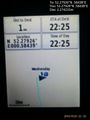
Proof. @52.2793,.5844
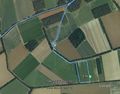
Google Earth Track


Achievements
Sourcerer earned the OpenStreetMap achievement
|
Expeditions and Plans
| 2015-11-25 | ||
|---|---|---|
| Cambridge, United Kingdom | Sourcerer | 2) In a field between Cavenham and the A14, Suffolk, UK. |
| Norwich, United Kingdom | Sourcerer | 1) In a field west of Dunwich, Suffolk, UK. |
| Bergen, Norway | Phi-loci-raptor, That creepy feeling you get off | Well... 500m off the road, not too far from home? I'd like to define a new ... |
Sourcerer's Expedition Links
2015-11-25 52 1 - 2015-11-25 52 0 - 2015-11-26 52 1 - KML file download of Sourcerer's expeditions for use with Google Earth.