2015-11-25 52 0
From Geohashing
Revision as of 22:28, 25 November 2015 by imported>Sourcerer ([live picture] Proof. [http://www.openstreetmap.org/?lat=52.27927923&lon=.58437824&zoom=16&layers=B000FTF @52.2793,.5844])
| Wed 25 Nov 2015 in 52,0: 52.2792589, 0.5843808 geohashing.info google osm bing/os kml crox |
Location
In a field between Cavenham and the A14, Suffolk, UK.
Participants
Plans
Expedition two of four spanning midnight - 2015-11-25 52 1 - 2015-11-25 52 0 - 2015-11-26 52 1 - 2010-03-31 52 1 Retro - ETA 20:45.
Expedition
- Arrived. -- Sourcerer (talk) @52.2792,.5844 22:26, 25 November 2015 (GMT)
Photos
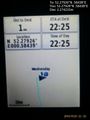
Proof. @52.2793,.5844

Achievements
Sourcerer earned the OpenStreetMap achievement
|
Expeditions and Plans
| 2015-11-25 | ||
|---|---|---|
| Cambridge, United Kingdom | Sourcerer | 2) In a field between Cavenham and the A14, Suffolk, UK. |
| Norwich, United Kingdom | Sourcerer | 1) In a field west of Dunwich, Suffolk, UK. |
| Bergen, Norway | Phi-loci-raptor, That creepy feeling you get off | Well... 500m off the road, not too far from home? I'd like to define a new ... |
Sourcerer's Expedition Links
2015-11-25 52 1 - 2015-11-25 52 0 - 2015-11-26 52 1 - KML file download of Sourcerer's expeditions for use with Google Earth.