Difference between revisions of "2015-12-23 52 -0"
From Geohashing
imported>Sourcerer (→Planning) |
m (Location correction) |
||
| (8 intermediate revisions by 2 users not shown) | |||
| Line 7: | Line 7: | ||
}} | }} | ||
__NOTOC__ | __NOTOC__ | ||
| − | |||
== Location == | == Location == | ||
| − | In a field, east of Kettering, Northamptonshire, UK. | + | 3) In a field, east of Kettering, Northamptonshire, UK. |
== Participants == | == Participants == | ||
| Line 22: | Line 21: | ||
== Expedition == | == Expedition == | ||
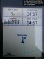
| + | *Arrived. -- [[User:Sourcerer|Sourcerer]] ([[User talk:Sourcerer|talk]]) [http://www.openstreetmap.org/?lat=52.40650713&lon=-.67224741&zoom=16&layers=B000FTF @52.4065,-.6722] 14:57, 23 December 2015 (GMT) | ||
| + | There was space to park in the access road to a barn. Across the road, through a gate, the field perimeter led in the right direction. A few steps between rows of winter wheat led to the hashpoint. Returning the same way, it was easier to squeeze through the hedge. | ||
== Photos == | == Photos == | ||
<gallery> | <gallery> | ||
| + | Image:2015-12-23_52_-0_Sourcerer_1450882631344.jpg | Proof. [http://www.openstreetmap.org/?lat=52.40650713&lon=-.67224741&zoom=16&layers=B000FTF @52.4065,-.6722] | ||
| + | Image:2015-12-23_52_-0_Sourcerer_1450882708515.jpg | View. [http://www.openstreetmap.org/?lat=52.40648031&lon=-.67225277&zoom=16&layers=B000FTF @52.4065,-.6723] | ||
| + | Image:2015-12-23_52_-0_Sourcerer.jpg | Google Earth Track | ||
</gallery> | </gallery> | ||
== Achievements == | == Achievements == | ||
{{#vardefine:ribbonwidth|700px}} | {{#vardefine:ribbonwidth|700px}} | ||
| − | |||
{{Sourcerer_links | {{Sourcerer_links | ||
| Line 39: | Line 42: | ||
}} | }} | ||
| − | |||
| − | |||
[[Category:Expeditions]] | [[Category:Expeditions]] | ||
[[Category:Expeditions with photos]] | [[Category:Expeditions with photos]] | ||
[[Category:Coordinates reached]] | [[Category:Coordinates reached]] | ||
| − | + | {{location|GB|ENG|NNH}} | |
Latest revision as of 14:12, 4 December 2022
| Wed 23 Dec 2015 in Northampton, UK: 52.4065343, -0.6722384 geohashing.info google osm bing/os kml crox |
Location
3) In a field, east of Kettering, Northamptonshire, UK.
Participants
Plans
Multihash - 2015-12-23 52 1 - 2015-12-23 52 0 - 2015-12-23 52 -0 - 2015-12-23 52 -1
Expedition
- Arrived. -- Sourcerer (talk) @52.4065,-.6722 14:57, 23 December 2015 (GMT)
There was space to park in the access road to a barn. Across the road, through a gate, the field perimeter led in the right direction. A few steps between rows of winter wheat led to the hashpoint. Returning the same way, it was easier to squeeze through the hedge.
Photos
Proof. @52.4065,-.6722
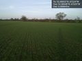
View. @52.4065,-.6723
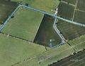
Google Earth Track


Achievements
Expeditions and Plans
| 2015-12-23 | ||
|---|---|---|
| Mannheim, Germany | Lord Vetinari, DODO | The hash is in an urban area near Heidelberg Main Station. |
| Kassel, Germany | GeorgDerReisende | The hash lay in the forest above Hann. Münden. |
| Northampton, United Kingdom | Sourcerer | 3) In a field, east of Kettering, Northamptonshire, UK. |
| Birmingham, United Kingdom | Sourcerer | 4) In a field, east of Solihull, West Midlands, UK. |
| Cambridge, United Kingdom | Sourcerer | 2) In Thetford forest north of Elveden, just over the border into Norfolk, ... |
| Norwich, United Kingdom | Sourcerer | 1) In a field south west of Kessingland, Suffolk, UK. |
Sourcerer's Expedition Links
2015-12-23 52 0 - 2015-12-23 52 -0 - 2015-12-23 52 -1 - KML file download of Sourcerer's expeditions for use with Google Earth.