Difference between revisions of "2016-01-04 52 1"
imported>Sourcerer m (→Planning) |
imported>FippeBot m (Location) |
||
| (5 intermediate revisions by one other user not shown) | |||
| Line 9: | Line 9: | ||
== Location == | == Location == | ||
| − | + | 2) In a field west of Bodham close and All Saints Church, Norfolk, UK. | |
== Participants == | == Participants == | ||
| Line 17: | Line 17: | ||
== Plans == | == Plans == | ||
| + | Expedition two of four spanning midnight - [[2015-11-08 52 1|2015-11-08 52 1 Retro]] - [[2016-01-04 52 1]] - [[2016-01-04 51 1]] - [[2016-01-05 52 0]] - ETA 20:35. | ||
| + | This is under 450 metres from [[2015-11-08 52 1]] where there is a good parking place. A retro visit was made and only took a couple of minutes. | ||
== Expedition == | == Expedition == | ||
| − | + | After a late departure my arrival was 15 minutes behind schedule. Low fuel and slow local traffic delayed me more. The expedition followed a public footpath with a few paces into the field at the end. It was still and starry with a temperature around 7C. | |
| − | |||
| − | |||
== Photos == | == Photos == | ||
<gallery> | <gallery> | ||
| + | Image:2016-01-04_52_1_Sourcerer_1451940568797.jpg | Arrival proof. [http://www.openstreetmap.org/?lat=52.90740430&lon=1.15540981&zoom=16&layers=B000FTF @52.9074,1.1554] | ||
| + | Image:2016-01-04_52_1_Sourcerer.jpg | Google Earth Track. | ||
</gallery> | </gallery> | ||
| Line 39: | Line 41: | ||
}} | }} | ||
| − | + | ||
| − | |||
[[Category:Expeditions]] | [[Category:Expeditions]] | ||
[[Category:Expeditions with photos]] | [[Category:Expeditions with photos]] | ||
[[Category:Coordinates reached]] | [[Category:Coordinates reached]] | ||
| − | + | {{location|GB|ENG|NFK}} | |
Latest revision as of 06:24, 15 August 2019
| Mon 4 Jan 2016 in Norwich, UK: 52.9073868, 1.1554141 geohashing.info google osm bing/os kml crox |
Location
2) In a field west of Bodham close and All Saints Church, Norfolk, UK.
Participants
Plans
Expedition two of four spanning midnight - 2015-11-08 52 1 Retro - 2016-01-04 52 1 - 2016-01-04 51 1 - 2016-01-05 52 0 - ETA 20:35.
This is under 450 metres from 2015-11-08 52 1 where there is a good parking place. A retro visit was made and only took a couple of minutes.
Expedition
After a late departure my arrival was 15 minutes behind schedule. Low fuel and slow local traffic delayed me more. The expedition followed a public footpath with a few paces into the field at the end. It was still and starry with a temperature around 7C.
Photos
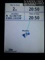
Arrival proof. @52.9074,1.1554
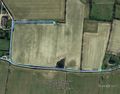
Google Earth Track.


Achievements
Expeditions and Plans
| 2016-01-04 | ||
|---|---|---|
| Nürnberg, Germany | Klaus | field close to the borders of Hohenpölz |
| Bonn, Germany | Burgman | A small path in Rösrath. |
| Canterbury, United Kingdom | Sourcerer | 3) In a field, south of Wrabness and the river Stour, Suffolk, UK. |
| Norwich, United Kingdom | Sourcerer | 2) In a field west of Bodham close and All Saints Church, Norfolk, UK. |
Sourcerer's Expedition Links
2016-01-01 52 0 - 2016-01-04 52 1 - 2016-01-04 51 1 - KML file download of Sourcerer's expeditions for use with Google Earth.