Difference between revisions of "2016-04-02 52 1"
From Geohashing
imported>ChromeCrusaders ([live] Did it) |
imported>ChromeCrusaders |
||
| Line 14: | Line 14: | ||
*[[User:Sourcerer|Sourcerer]] | *[[User:Sourcerer|Sourcerer]] | ||
| + | *[[User:ChromeCrusaders|ChromeCrusaders]] | ||
== Plans == | == Plans == | ||
| Line 27: | Line 28: | ||
-- [[User:ChromeCrusaders|ChromeCrusaders]] ([[User talk:ChromeCrusaders|talk]]) [http://www.openstreetmap.org/?lat=52.56033830&lon=1.35767500&zoom=16&layers=B000FTF @52.5603,1.3577] 16:51, 2 April 2016 (GMT+01:00) | -- [[User:ChromeCrusaders|ChromeCrusaders]] ([[User talk:ChromeCrusaders|talk]]) [http://www.openstreetmap.org/?lat=52.56033830&lon=1.35767500&zoom=16&layers=B000FTF @52.5603,1.3577] 16:51, 2 April 2016 (GMT+01:00) | ||
| − | + | ChromeCrusaders - Ditto that, but with the assistance of day light! | |
| + | |||
| + | |||
| − | |||
| − | |||
<gallery perrow="5"> | <gallery perrow="5"> | ||
Image:2016-04-02 52 1 Sourcerer Proof.jpg | Proof | Image:2016-04-02 52 1 Sourcerer Proof.jpg | Proof | ||
Image:2016-04-02 52 1 Sourcerer Track.jpg | Track in Google Earth | Image:2016-04-02 52 1 Sourcerer Track.jpg | Track in Google Earth | ||
| + | Image:2016-04-02_52_1CC1.jpg | Chrome's amazing face with friend | ||
| + | Image:Screenshot_2016-04-02-16-49-34-1-.png | Chrome's Proof | ||
| + | Image:20160402_165204-1-.jpg | XKCD IN DIRT! | ||
</gallery> | </gallery> | ||
== Achievements == | == Achievements == | ||
{{#vardefine:ribbonwidth|800px}} | {{#vardefine:ribbonwidth|800px}} | ||
| + | |||
| + | {{drag-along | ||
| + | | latitude = 52 | ||
| + | | longitude = 1 | ||
| + | | date = 2016-03-28 | ||
| + | | partner = Joseph | ||
| + | | name = ChromeCrusaders | ||
| + | }} | ||
{{Sourcerer_links | {{Sourcerer_links | ||
Revision as of 18:21, 2 April 2016
| Sat 2 Apr 2016 in Norwich, UK: 52.5602894, 1.3576946 geohashing.info google osm bing/os kml crox |
Location
A field south of Poringland, Norfolk, UK.
Participants
Plans
Expedition two of two spanning midnight - 2016-04-01 52 1 - 2016-04-02 52 1 - ETA 00:00.
Expedition
This was easy. There was dry parking at the field entrance and the hashpoint was a few paces into the field.
- Did it
-- ChromeCrusaders (talk) @52.5603,1.3577 16:51, 2 April 2016 (GMT+01:00)
ChromeCrusaders - Ditto that, but with the assistance of day light!
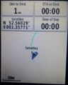
Proof
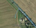
Track in Google Earth
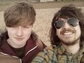
Chrome's amazing face with friend
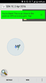
Chrome's Proof
XKCD IN DIRT!


Achievements
ChromeCrusaders earned the Drag-along achievement
|
Expeditions and Plans
| 2016-04-02 | ||
|---|---|---|
| Seattle, Washington | Thomcat | The woods in Pigeon Point, not far off a trail. |
| Mannheim, Germany | DODO | A muddy field just outside Frankenthal. |
| Frankfurt am Main, Germany | TwoFx, TwoFx's mother, Nelli, the family dog | A field north of Leun, a small town in Hesse, Germany |
| Norwich, United Kingdom | Sourcerer, ChromeCrusaders | A field south of Poringland, Norfolk, UK. |
Sourcerer's Expedition Links
2016-04-01 52 1 - 2016-04-02 52 1 - 2016-04-03 52 1 - KML file download of Sourcerer's expeditions for use with Google Earth.