Difference between revisions of "2016-04-02 52 1"
From Geohashing
imported>ChromeCrusaders |
imported>FippeBot m (Location) |
||
| (One intermediate revision by one other user not shown) | |||
| Line 21: | Line 21: | ||
== Expedition == | == Expedition == | ||
| + | |||
| + | === Sourcerer === | ||
This was easy. There was dry parking at the field entrance and the hashpoint was a few paces into the field. | This was easy. There was dry parking at the field entrance and the hashpoint was a few paces into the field. | ||
| + | === ChromeCrusaders === | ||
*Did it | *Did it | ||
| − | + | ||
| + | -- [[User:ChromeCrusaders|ChromeCrusaders]] ([[User talk:ChromeCrusaders|talk]]) [http://www.openstreetmap.org/?lat=52.56033830&lon=1.35767500&zoom=16&layers=B000FTF @52.5603,1.3577] 16:51, 2 April 2016 (GMT+01:00) | ||
ChromeCrusaders - Ditto that, but with the assistance of day light! | ChromeCrusaders - Ditto that, but with the assistance of day light! | ||
| − | |||
| − | |||
| − | |||
<gallery perrow="5"> | <gallery perrow="5"> | ||
| − | Image:2016-04-02 52 1 Sourcerer Proof.jpg | Proof | + | Image:2016-04-02 52 1 Sourcerer Proof.jpg | Sourcerer's Proof |
| − | Image:2016-04-02 52 1 Sourcerer Track.jpg | Track in Google Earth | + | Image:2016-04-02 52 1 Sourcerer Track.jpg | Sourcerer's Track in Google Earth |
Image:2016-04-02_52_1CC1.jpg | Chrome's amazing face with friend | Image:2016-04-02_52_1CC1.jpg | Chrome's amazing face with friend | ||
Image:Screenshot_2016-04-02-16-49-34-1-.png | Chrome's Proof | Image:Screenshot_2016-04-02-16-49-34-1-.png | Chrome's Proof | ||
| Line 43: | Line 44: | ||
== Achievements == | == Achievements == | ||
{{#vardefine:ribbonwidth|800px}} | {{#vardefine:ribbonwidth|800px}} | ||
| + | |||
| + | {{Midnight geohash | ||
| + | | latitude = 52 | ||
| + | | longitude = 1 | ||
| + | | date = 2016-03-28 | ||
| + | | name = Sourcerer | ||
| + | }} | ||
{{drag-along | {{drag-along | ||
| Line 62: | Line 70: | ||
[[Category:Expeditions with photos]] | [[Category:Expeditions with photos]] | ||
[[Category:Coordinates reached]] | [[Category:Coordinates reached]] | ||
| + | {{location|GB|ENG|NFK}} | ||
Latest revision as of 00:05, 16 August 2019
| Sat 2 Apr 2016 in Norwich, UK: 52.5602894, 1.3576946 geohashing.info google osm bing/os kml crox |
Location
A field south of Poringland, Norfolk, UK.
Participants
Plans
Expedition two of two spanning midnight - 2016-04-01 52 1 - 2016-04-02 52 1 - ETA 00:00.
Expedition
Sourcerer
This was easy. There was dry parking at the field entrance and the hashpoint was a few paces into the field.
ChromeCrusaders
- Did it
-- ChromeCrusaders (talk) @52.5603,1.3577 16:51, 2 April 2016 (GMT+01:00)
ChromeCrusaders - Ditto that, but with the assistance of day light!
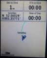
Sourcerer's Proof
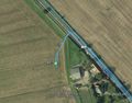
Sourcerer's Track in Google Earth
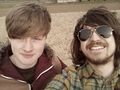
Chrome's amazing face with friend
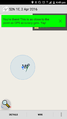
Chrome's Proof
XKCD IN DIRT!


Achievements
Sourcerer earned the Midnight Geohash achievement
|
ChromeCrusaders earned the Drag-along achievement
|
Expeditions and Plans
| 2016-04-02 | ||
|---|---|---|
| Seattle, Washington | Thomcat | The woods in Pigeon Point, not far off a trail. |
| Mannheim, Germany | DODO | A muddy field just outside Frankenthal. |
| Frankfurt am Main, Germany | TwoFx, TwoFx's mother, Nelli, the family dog | A field north of Leun, a small town in Hesse, Germany |
| Norwich, United Kingdom | Sourcerer, ChromeCrusaders | A field south of Poringland, Norfolk, UK. |
Sourcerer's Expedition Links
2016-04-01 52 1 - 2016-04-02 52 1 - 2016-04-03 52 1 - KML file download of Sourcerer's expeditions for use with Google Earth.