Difference between revisions of "2016-05-01 global"
imported>Thomcat ([live picture]Lewis and Clark Bridge [http://www.openstreetmap.org/?lat=46.09850580&lon=-122.98446650&zoom=16&layers=B000FTF @46.0985,-122.9845]) |
imported>Fippe |
||
| (8 intermediate revisions by 3 users not shown) | |||
| Line 21: | Line 21: | ||
== Participants == | == Participants == | ||
| − | + | ||
| − | |||
* [[User:Jiml|Jim]] | * [[User:Jiml|Jim]] | ||
| − | |||
* [[User:Thomcat|Thomcat]] | * [[User:Thomcat|Thomcat]] | ||
| − | |||
== Plans == | == Plans == | ||
| Line 44: | Line 41: | ||
== Expedition == | == Expedition == | ||
| − | |||
*Making good time, should be at highway 30 and Nimitz at 3:50. -- [[User:Thomcat|Thomcat]] ([[User talk:Thomcat|talk]]) [http://www.openstreetmap.org/?lat=46.83833010&lon=-122.98590530&zoom=16&layers=B000FTF @46.8383,-122.9859] 14:06, 1 May 2016 (PDT) | *Making good time, should be at highway 30 and Nimitz at 3:50. -- [[User:Thomcat|Thomcat]] ([[User talk:Thomcat|talk]]) [http://www.openstreetmap.org/?lat=46.83833010&lon=-122.98590530&zoom=16&layers=B000FTF @46.8383,-122.9859] 14:06, 1 May 2016 (PDT) | ||
| − | *Jim is also en route, solo, and is just leaving Claskanie, so | + | *Jim is also en route, solo, and is just leaving Claskanie, so he's about an hour away. [[User:Jiml|Jiml]] ([[User talk:Jiml|talk]]) 21:23, 1 May 2016 (UTC) |
| + | |||
| + | Thomcat arrived about 5 minutes to 4:00, after cruising down I-5 and across highway 30 and snapping a few pictures en route (below). Turning left onto Nimitz, I parked and noted to the log, then looked around for anyone else. | ||
| + | |||
| + | *186 mi, 3 hrs 16 min. -- [[User:Thomcat|Thomcat]] ([[User talk:Thomcat|talk]]) [http://www.openstreetmap.org/?lat=46.19420530&lon=-123.76956240&zoom=16&layers=B000FTF @46.1942,-123.7696] 15:58, 1 May 2016 (PDT) | ||
| + | :At this point, it turns out that Jim was actually sitting by the side of Hwy 30, right across the street, figuring he was pretty obviously from the Internet. :-) | ||
| + | After waiting a bit, I headed up the hill - stopping to pen another note. | ||
| + | :Jim punched in the coordinates from Thomcat's 15:58 message and realized he had been 500 feet away from Jim, so he must have headed into the facility. Jim followed. | ||
| + | |||
| + | *Assume I was first to arrive, heading to park near hashpoint. Not much connectivity. -- [[User:Thomcat|Thomcat]] ([[User talk:Thomcat|talk]]) [http://www.openstreetmap.org/?lat=46.19289660&lon=-123.77304540&zoom=16&layers=B000FTF @46.1929,-123.7730] 16:11, 1 May 2016 (PDT) | ||
| + | |||
| + | Signs indicated this was a private community, but no gate or fence was evident. My interpretation (later born out by Jim) was that we could knock on the appropriate door and gain permission, our ambassador status overriding any privacy for an individual yard. | ||
| + | |||
| + | Reached the approximate building, but misread the GPS, thinking the point was behind the building on the eastern side of the street. I even went down the block to see a blocked off road that might lead behind the building. | ||
| + | |||
| + | Parking, I then studied the actual GPS/Geohashdroid instead of just the coordinates I punched into my car. A car cruised by slowly, then returned with a driver questioning if I was from the internet :) | ||
| + | |||
| + | Jim parked, we shook hands and then headed in the direction of the point. A playground was situated between two buildings and in use by basketball players, swinging kids and a dog. As we agreed on our general distance (Jim in English units, Thomcat in Metric) we found that we were... on the spot! | ||
| + | |||
| + | Snapped a few more photos and chatted at the car, then headed to the visitor parking area to chat further. With no sign or contact from the other potential attendees, Thomcat headed downhill and east then north to Seattle. Birthday Globalhash achieved! | ||
== Tracklog == | == Tracklog == | ||
| Line 66: | Line 81: | ||
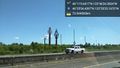
Image:2016-05-01_global_thomcat_1462140387698.jpg|Lewis and Clark Bridge [http://www.openstreetmap.org/?lat=46.09850580&lon=-122.98446650&zoom=16&layers=B000FTF @46.0985,-122.9845] | Image:2016-05-01_global_thomcat_1462140387698.jpg|Lewis and Clark Bridge [http://www.openstreetmap.org/?lat=46.09850580&lon=-122.98446650&zoom=16&layers=B000FTF @46.0985,-122.9845] | ||
| + | |||
| + | Image:2016-05-01_global_thomcat_1462144940307.jpg|Success [http://www.openstreetmap.org/?lat=46.18604960&lon=-123.77624310&zoom=16&layers=B000FTF @46.1860,-123.7762] | ||
| + | |||
| + | Image:IMG 20160501 162230.jpg|More proof | ||
| + | |||
| + | Image:2016-05-01 Global Pano.jpg|Playground, basketball and back corner of building | ||
| + | |||
</gallery> | </gallery> | ||
== Achievements == | == Achievements == | ||
{{#vardefine:ribbonwidth|800px}} | {{#vardefine:ribbonwidth|800px}} | ||
| − | |||
| − | |||
| − | |||
| − | |||
| − | |||
| − | |||
| − | |||
| − | + | * Land Geohash | |
| + | * Global Geohash | ||
| + | {{globalhash | ||
| + | | date = 2016-05-01 | ||
| + | | name = [[User:Thomcat|Thomcat]] and [[User:Jiml|Jim]] | ||
| + | | image = | ||
| + | }} | ||
| + | {{xkcd-100-Honorable-Mention | ||
| + | | latitude = 46 | ||
| + | | longitude = -123 | ||
| + | | date = 2016-05-01 | ||
| + | | distance = 100 miles | ||
| + | | name = Thomcat and Jim | ||
| + | }} | ||
| − | + | {{Two to the N achievement | count = 0 | date = 2016-05-01 | name = [[User:Thomcat|Thomcat]] | global = true | reached = true }} | |
| + | {{Two to the N achievement | count = 0 | date = 2016-05-01 | name = [[User:Jiml|Jim]] | global = true | reached = true }} | ||
| − | + | [[Category:Meetup in 46 -123]] | |
[[Category:Expeditions]] | [[Category:Expeditions]] | ||
| − | |||
[[Category:Expeditions with photos]] | [[Category:Expeditions with photos]] | ||
[[Category:Expeditions with videos]] | [[Category:Expeditions with videos]] | ||
| − | |||
| − | |||
| − | |||
| − | |||
[[Category:Coordinates reached]] | [[Category:Coordinates reached]] | ||
| − | + | {{location|US|OR|CT}} | |
| − | |||
| − | |||
| − | |||
| − | |||
| − | |||
| − | |||
| − | |||
| − | |||
| − | |||
| − | |||
| − | |||
| − | |||
| − | |||
| − | |||
| − | |||
| − | |||
| − | |||
Latest revision as of 18:32, 8 August 2019
|
Globalhash on Sun 1 May 2016: |
Location
Behind some apartments in Astoria, Oregon
Participants
Plans
None yet, except Jim is thinking about how to get there and what he has to arrange to make that happen.
- Thomcat is going to be coming down from Seattle for a birthday globalhash
- Jim's going to be coming from Beaverton/Hillsboro, and will be free to start out around 11:30 or Noon due to an earlier morning commitment.
- Shmur's coming from PDX, but I'm not sure if they are interested in carpooling.
- Zhukant is planning on heading there, and to the coast, with a drag-along.
It sounds like everyone is going independently. I think we're aiming for maybe about 4PM. Maybe we should meet out near Hwy 30 before venturing in closer?
- En route solo in a few minutes; meeting at the intersection of Highway 30 and Nimitz Drive makes sense. --Thomcat (talk) 19:33, 1 May 2016 (UTC)
Expedition
- Making good time, should be at highway 30 and Nimitz at 3:50. -- Thomcat (talk) @46.8383,-122.9859 14:06, 1 May 2016 (PDT)
- Jim is also en route, solo, and is just leaving Claskanie, so he's about an hour away. Jiml (talk) 21:23, 1 May 2016 (UTC)
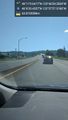
Thomcat arrived about 5 minutes to 4:00, after cruising down I-5 and across highway 30 and snapping a few pictures en route (below). Turning left onto Nimitz, I parked and noted to the log, then looked around for anyone else.
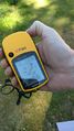
- 186 mi, 3 hrs 16 min. -- Thomcat (talk) @46.1942,-123.7696 15:58, 1 May 2016 (PDT)
- At this point, it turns out that Jim was actually sitting by the side of Hwy 30, right across the street, figuring he was pretty obviously from the Internet. :-)
After waiting a bit, I headed up the hill - stopping to pen another note.
- Jim punched in the coordinates from Thomcat's 15:58 message and realized he had been 500 feet away from Jim, so he must have headed into the facility. Jim followed.
- Assume I was first to arrive, heading to park near hashpoint. Not much connectivity. -- Thomcat (talk) @46.1929,-123.7730 16:11, 1 May 2016 (PDT)
Signs indicated this was a private community, but no gate or fence was evident. My interpretation (later born out by Jim) was that we could knock on the appropriate door and gain permission, our ambassador status overriding any privacy for an individual yard.
Reached the approximate building, but misread the GPS, thinking the point was behind the building on the eastern side of the street. I even went down the block to see a blocked off road that might lead behind the building.
Parking, I then studied the actual GPS/Geohashdroid instead of just the coordinates I punched into my car. A car cruised by slowly, then returned with a driver questioning if I was from the internet :)
Jim parked, we shook hands and then headed in the direction of the point. A playground was situated between two buildings and in use by basketball players, swinging kids and a dog. As we agreed on our general distance (Jim in English units, Thomcat in Metric) we found that we were... on the spot!
Snapped a few more photos and chatted at the car, then headed to the visitor parking area to chat further. With no sign or contact from the other potential attendees, Thomcat headed downhill and east then north to Seattle. Birthday Globalhash achieved!
Tracklog
Photos
Sculptures @46.4318,-122.8898
Lewis and Clark Bridge @46.1093,-122.9576
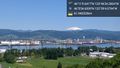
Lewis and Clark Bridge @46.0985,-122.9845

Success @46.1860,-123.7762
More proof
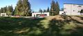
Playground, basketball and back corner of building


Achievements
- Land Geohash
- Global Geohash
Thomcat and Jim earned the Globalhash achievement
|
Thomcat and Jim earned the XKCD-100 Honorable Mention Achievement
|
