Difference between revisions of "2016-06-27 52 1"
From Geohashing
imported>Sourcerer m (→Plans) |
imported>FippeBot m (Location) |
||
| Line 45: | Line 45: | ||
[[Category:Expeditions with photos]] | [[Category:Expeditions with photos]] | ||
[[Category:Coordinates reached]] | [[Category:Coordinates reached]] | ||
| + | {{location|GB|ENG|NFK}} | ||
Latest revision as of 00:52, 16 August 2019
| Mon 27 Jun 2016 in Norwich, UK: 52.8295767, 1.0358881 geohashing.info google osm bing/os kml crox |
Location
A meadow north east of Hindolveston, Norfolk, UK.
Participants
Plans
Two of three spanning midnight - 2012-04-27 52 1 Retro - 2016-06-27 52 1 - 2016-06-28 52 1 - ETA 23:20.
This looks like a livestock meadow and might not be reachable. But perhaps this year, it's a crop instead.
Expedition
This was an unexpected success. The predicted livestock was absent. There was a convenient field perimeter path, a wide bridge over a drainage ditch and no fence or gate. The final field contained hay. There was no 3G signal for a "live" arrival message.
Photos
- Photo Gallery
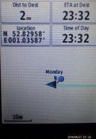
Proof
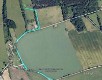
Google Earth Track


Achievements
Expeditions and Plans
| 2016-06-27 | ||
|---|---|---|
| Norwich, United Kingdom | Sourcerer | A meadow north east of Hindolveston, Norfolk, UK. |
| Sandviken, Sweden | FelixTheCat | Vintjärn, Falun Municipality, Sweden. |
Sourcerer's Expedition Links
2016-06-24 52 1 - 2016-06-27 52 1 - 2016-06-28 52 1 - KML file download of Sourcerer's expeditions for use with Google Earth.