2018-05-21 52 0
From Geohashing
Revision as of 13:43, 21 May 2018 by imported>Sourcerer ([live picture] Ditch. [http://www.openstreetmap.org/?lat=52.75149822&lon=.37748873&zoom=16&layers=B000FTF @52.7515,.3775])
| Mon 21 May 2018 in Cambridge: 52.7499123, 0.3766712 geohashing.info google osm bing/os kml crox |
Location
West of the Great Ouse, Kings Lynn, Norfolk, UK.
Participants
The following people will try to make it:
The following people send their apologies:
- Benjw is involved in running the Cambridge Beer Festival, which is open to the public this week, not leaving much time for hashing.
- Tongs/B is saying it's looking unlikely (see the talk page for more).
Plans
The hashpoint is in a field and unlikely to be reachable without crop damage. However 2018-05-21 52 -0 is in woodland, close to footpaths and 2018-05-21 52 1 is on a field perimeter with an access track. Sourcerer is thinking about attempting a triple of which two might succeed. There have been occasions when improbable locations were easy. For example new houses had been built. The crop turned out to be new tarmac.
Expedition
Photos
- Gallery
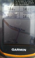
Darn. @52.7515,.3775
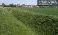
Ditch. @52.7515,.3775

