Difference between revisions of "2020-09-24 49 7"
([live] Good morning all, this ist the First of hopefully three Hashes today and Mampfred Just biarded bis train Ro meet Up with Rincewind) |
m (Location) |
||
| (4 intermediate revisions by one other user not shown) | |||
| Line 1: | Line 1: | ||
| − | + | {{meetup graticule | |
| − | |||
| − | |||
| − | |||
| − | |||
| − | |||
| − | |||
| − | |||
| − | |||
| lat=49 | | lat=49 | ||
| lon=7 | | lon=7 | ||
| Line 14: | Line 6: | ||
__NOTOC__ | __NOTOC__ | ||
== Location == | == Location == | ||
| − | + | Deep in the woods of [[49,7]]. | |
== Participants == | == Participants == | ||
| − | + | * [[User:Rincewind|Rincewind]] | |
| − | + | * [[User:Mampfred|Mampfred]] | |
== Plans == | == Plans == | ||
| − | < | + | <table style="border-width: 1px; border-spacing: 0px; border-style: solid solid solid solid; border-color: lightgray;"> |
| + | <tr> | ||
| + | <td style="border-width: 5px; border-spacing: 2px; border-style: hidden hidden hidden solid; border-color: #8268ed; border-collapse: separate;"></td> | ||
| + | <td style="padding: 0px 12px 0px 10px;">Multihash x 3: [[2020-09-24 49 7|Kaiserslautern]], [[2020-09-24 49 9|Würzburg]], [[2020-09-24 49 8|Darmstadt]]</td> | ||
| + | </tr> | ||
| + | </table> | ||
== Expedition == | == Expedition == | ||
| − | + | This expedition was part of the hashiversary of Rincewind and Mampfred which was hastily planned [[2020-09-24 50 8|here]]. We'll leave the hashdroid messages in here (fixed for spelling) and add some details: | |
| + | * Good morning all, this ist the first of hopefully three hashes today and Mampfred just boarded his train to meet up with Rincewind -- [[User:Mampfred|Mampfred]] ([[User talk:Mampfred|talk]]) [https://openstreetmap.org/?lat=50.14928000&lon=8.35209400&zoom=16&layers=B000FTF @50.1493,8.3521] 07:38, 24 September 2020 (GMT+02:00) | ||
| − | * | + | Rincewind was the driver for the day and after getting some food for the road we headed out. |
| − | + | ||
| − | + | * Succesfully came together at the station, reached the parking position at the hash, 2km hike ahead. -- [[User:Mampfred|Mampfred]] ([[User talk:Mampfred|talk]]) [https://openstreetmap.org/?lat=49.87512950&lon=7.61585560&zoom=16&layers=B000FTF @49.8751,7.6159] 09:56, 24 September 2020 (GMT+02:00) | |
| + | |||
| + | We found the hash pretty conveniently right next to a forest path so that was definitely one of the easier hashes in our career. At that point we got a little suspicious of the hash gods ... would we be as lucky for all three today? | ||
| + | |||
| + | Rincewind even brought some color to properly mark the hash, and when we were done, we walked back to the car and moved on to [[2020-09-24 49 9]]. | ||
== Photos == | == Photos == | ||
| − | |||
| − | |||
| − | |||
<gallery perrow="5"> | <gallery perrow="5"> | ||
| + | Image:2020-09-24_49_7_Mampfred_1600935910289.jpg | Coordinates reached [https://openstreetmap.org/?lat=49.88495200&lon=7.60396320&zoom=16&layers=B000FTF @49.8850,7.6040] | ||
| + | Image:2020-09-24_49_7_the_hash.jpg | Looking at the hash | ||
| + | Image:2020-09-24_49_7_hash_grin_sortof.jpg | Hash grin with a "number one" sign | ||
| + | Image:2020-09-24_49_7_xkcd_marks_the_hash.jpg | Xkcd marks the spot | ||
</gallery> | </gallery> | ||
| + | |||
| + | == Tracklog == | ||
| + | {{tracklog | Track_2020-09-24_104945.gpx}} | ||
== Achievements == | == Achievements == | ||
{{#vardefine:ribbonwidth|800px}} | {{#vardefine:ribbonwidth|800px}} | ||
| − | |||
| − | |||
| − | |||
| − | |||
| − | |||
| − | |||
| − | |||
| − | |||
| − | |||
| − | |||
| − | |||
| − | |||
| − | |||
| − | |||
| − | |||
| − | |||
[[Category:Expeditions]] | [[Category:Expeditions]] | ||
| − | |||
[[Category:Expeditions with photos]] | [[Category:Expeditions with photos]] | ||
| − | |||
| − | |||
| − | |||
| − | |||
| − | |||
[[Category:Coordinates reached]] | [[Category:Coordinates reached]] | ||
| − | + | {{location|DE|RP|KH}} | |
| − | |||
| − | |||
| − | |||
| − | |||
| − | |||
| − | |||
| − | |||
| − | |||
| − | |||
| − | |||
| − | |||
| − | |||
| − | |||
| − | |||
| − | |||
| − | |||
| − | |||
Latest revision as of 10:42, 12 October 2020
| Thu 24 Sep 2020 in 49,7: 49.8849309, 7.6040319 geohashing.info google osm bing/os kml crox |
Location
Deep in the woods of 49,7.
Participants
Plans
| Multihash x 3: Kaiserslautern, Würzburg, Darmstadt |
Expedition
This expedition was part of the hashiversary of Rincewind and Mampfred which was hastily planned here. We'll leave the hashdroid messages in here (fixed for spelling) and add some details:
- Good morning all, this ist the first of hopefully three hashes today and Mampfred just boarded his train to meet up with Rincewind -- Mampfred (talk) @50.1493,8.3521 07:38, 24 September 2020 (GMT+02:00)
Rincewind was the driver for the day and after getting some food for the road we headed out.
- Succesfully came together at the station, reached the parking position at the hash, 2km hike ahead. -- Mampfred (talk) @49.8751,7.6159 09:56, 24 September 2020 (GMT+02:00)
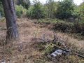
We found the hash pretty conveniently right next to a forest path so that was definitely one of the easier hashes in our career. At that point we got a little suspicious of the hash gods ... would we be as lucky for all three today?
Rincewind even brought some color to properly mark the hash, and when we were done, we walked back to the car and moved on to 2020-09-24 49 9.
Photos

Coordinates reached @49.8850,7.6040
Looking at the hash
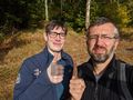
Hash grin with a "number one" sign
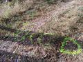
Xkcd marks the spot


Tracklog