Difference between revisions of "2021-07-26 40 -4"
m (Location) |
(→Photos) |
||
| (4 intermediate revisions by 3 users not shown) | |||
| Line 38: | Line 38: | ||
know a few kilometers from the geohash. On Monday, I would | know a few kilometers from the geohash. On Monday, I would | ||
not have enough time to explore it. Therefore, I decided | not have enough time to explore it. Therefore, I decided | ||
| − | to go on | + | to go on Saturday to already check out Monday's geohash |
and to look for pathways to the reservoir. I did not know | and to look for pathways to the reservoir. I did not know | ||
the condition of the roads and paths, so I took the | the condition of the roads and paths, so I took the | ||
lightest of my running motorcycles, ''die Krähe.'' | lightest of my running motorcycles, ''die Krähe.'' | ||
| − | I easily reached Monday's geohash on | + | I easily reached Monday's geohash on Saturday. It was just |
a 15 minutes ride and then | a 15 minutes ride and then | ||
500 meters walk. I took some photos, also on the way back. | 500 meters walk. I took some photos, also on the way back. | ||
| Line 52: | Line 52: | ||
To find the reservoir was more difficult. It required | To find the reservoir was more difficult. It required | ||
quite a walk around some fenced area. A couple of times | quite a walk around some fenced area. A couple of times | ||
| − | I was about to give up, but finally I found it. | + | I was about to give up, but finally I found it, |
| + | looking down on it from a hill. | ||
| + | I took a photo from the distance, but could not get close | ||
| + | to it. Later, in expedition [[2021-09-04_40_-4]], I found | ||
| + | a direct access. | ||
== Expedition == | == Expedition == | ||
<!-- how it all turned out. your narrative goes here. --> | <!-- how it all turned out. your narrative goes here. --> | ||
| + | On Monday, I left home at about 12:00. It was not yet that | ||
| + | hot, a comfortable 24°C. I had already explored roads | ||
| + | and parking space on Saturday, so I now took heavyweight | ||
| + | Wendy. | ||
| + | |||
| + | When walking the last bit after a nice 15 minutes ride, | ||
| + | I took quite a distant picture of the air navigation | ||
| + | antenna I had already captured from close on Saturday. | ||
| + | On Wendy, I only have a small tank bag, so I did not bring | ||
| + | the photo case with the tele lens. | ||
| + | |||
| + | I was at the geohash at about 12:20. | ||
| + | I easily found the marking I had put | ||
| + | on the Saturday exploration. So I tag this as | ||
| + | “Expedition without GPS”. However, | ||
| + | this would probablyh not qualify for the | ||
| + | No Batteries Achievement, as I used GPS to | ||
| + | originally find the point on Saturday. | ||
| + | |||
| + | Was back home at 12:45. Nice lunch break. | ||
== Tracklog == | == Tracklog == | ||
| Line 74: | Line 98: | ||
Image:2021-07-26_40_-4_L1040452.JPG | The search for the reservoir seemed to end here… | Image:2021-07-26_40_-4_L1040452.JPG | The search for the reservoir seemed to end here… | ||
Image:2021-07-26_40_-4_L1040453.JPG | … but there was a path around the fenced area. | Image:2021-07-26_40_-4_L1040453.JPG | … but there was a path around the fenced area. | ||
| − | Image:2021-07-26_40_-4_L1040459.JPG | Finally found the reservoir after a long walk, but the descent looked dangerous, so no direct access from here. | + | Image:2021-07-26_40_-4_L1040459.JPG | Finally found the reservoir after a long walk, but the descent looked dangerous, so no direct access from here. Later, in expedition [[2021-09-04_40_-4]], I found a direct access. |
| + | Image:2021-07-26_40_-4_L1040475.JPG | On Monday, I returned to the now valid geohash with Wendy. | ||
| + | Image:2021-07-26_40_-4_L1040476.JPG | While walking the last 500 meters, I noticed that I have a distant view on the antenna that I had captured from close on Saturday. | ||
| + | Image:2021-07-26_40_-4_L1040478.JPG | At the marking I had put on Saturday. | ||
| + | Image:2021-07-26_40_-4_L1040479.JPG | Back at the bike. | ||
</gallery> | </gallery> | ||
| Line 82: | Line 110: | ||
this section --> | this section --> | ||
| − | <!-- | + | <!-- An actual expedition: --> |
| − | [[Category: | + | [[Category:Expeditions]] |
[[Category:Expeditions with photos]] | [[Category:Expeditions with photos]] | ||
| + | |||
| + | [[Category:Expedition without GPS]] | ||
| + | |||
| + | |||
| + | <!-- if you reached your coords: --> | ||
| + | [[Category:Coordinates reached]] | ||
{{location|ES|MD}} | {{location|ES|MD}} | ||
Latest revision as of 08:19, 7 September 2021
| Mon 26 Jul 2021 in 40,-4: 40.3556627, -4.2709638 geohashing.info google osm bing/os kml crox |
Location
In the wilds, close to a path near Navas del Rey.
Participants
Plans
The weekend geohashes 2021-07-24 and 2021-07-25 were both in a southern part of my home graticule where I already had been hashing a couple of times. The geohash on Monday, 2021-07-26, however, looked interesting. It was very close to my home base but nevertheless in an area which I did not know. I was planning to do it on Monday during lunch break.
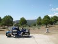
I saw on the Maps that there is a reservoir which I did not know a few kilometers from the geohash. On Monday, I would not have enough time to explore it. Therefore, I decided to go on Saturday to already check out Monday's geohash and to look for pathways to the reservoir. I did not know the condition of the roads and paths, so I took the lightest of my running motorcycles, die Krähe.
I easily reached Monday's geohash on Saturday. It was just a 15 minutes ride and then 500 meters walk. I took some photos, also on the way back. I arranged them here in the sequence of approaching the geohash. On Monday, I plan to be there at 12:00 or a little bit later.
To find the reservoir was more difficult. It required quite a walk around some fenced area. A couple of times I was about to give up, but finally I found it, looking down on it from a hill. I took a photo from the distance, but could not get close to it. Later, in expedition 2021-09-04_40_-4, I found a direct access.
Expedition
On Monday, I left home at about 12:00. It was not yet that hot, a comfortable 24°C. I had already explored roads and parking space on Saturday, so I now took heavyweight Wendy.
When walking the last bit after a nice 15 minutes ride, I took quite a distant picture of the air navigation antenna I had already captured from close on Saturday. On Wendy, I only have a small tank bag, so I did not bring the photo case with the tele lens.
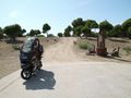
I was at the geohash at about 12:20. I easily found the marking I had put on the Saturday exploration. So I tag this as “Expedition without GPS”. However, this would probablyh not qualify for the No Batteries Achievement, as I used GPS to originally find the point on Saturday.
Was back home at 12:45. Nice lunch break.
Tracklog
Photos
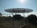
Antenna of the regional directorate of air navigation.
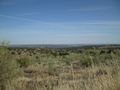
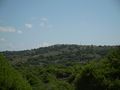
Lots of landscape.
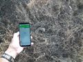
🤔
From here on I walk.
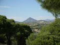
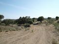
Nice views while walking towards the (future) geohash.
I put the two stones on the point to mark it for when I return the day after tomorrow.
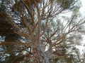
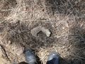
Looking straight up.
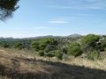
View from the geohash; looks like a quiet neighbourhood.
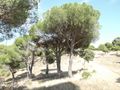
Looking back the path I came. The geohash is (will be) one meter left of the center tree.
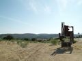
The search for the reservoir seemed to end here…
… but there was a path around the fenced area.
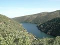
Finally found the reservoir after a long walk, but the descent looked dangerous, so no direct access from here. Later, in expedition 2021-09-04_40_-4, I found a direct access.
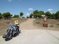
On Monday, I returned to the now valid geohash with Wendy.
While walking the last 500 meters, I noticed that I have a distant view on the antenna that I had captured from close on Saturday.
At the marking I had put on Saturday.
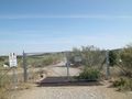
Back at the bike.


