Difference between revisions of "2022-02-26 52 9"
(DLichti's photos.) |
m (Adding hours) |
||
| (8 intermediate revisions by 3 users not shown) | |||
| Line 2: | Line 2: | ||
==Location== | ==Location== | ||
| − | |||
This Geohash is located in next to a path outside the golf course in [[wikipedia:Isernhagen|Isernhagen]]. | This Geohash is located in next to a path outside the golf course in [[wikipedia:Isernhagen|Isernhagen]]. | ||
==Participants== | ==Participants== | ||
| − | |||
* [[User:Fippe|Fippe]] | * [[User:Fippe|Fippe]] | ||
* [[User:DLichti|DLichti]] | * [[User:DLichti|DLichti]] | ||
* A friend | * A friend | ||
| + | * [[User:GeorgDerReisende|GeorgDerReisende]] | ||
==Plans== | ==Plans== | ||
| + | Meeting at the central train station at 10:00, taking a tram to Altwarmbüchen, a bus to Lohne, and walking the rest. | ||
| − | + | ===GeorgDerReisende=== | |
| + | The first announcement was for 16:00 and my plan was to be there at that time. | ||
| − | == Expedition == | + | ==Expedition== |
| + | === DLichti === | ||
| − | + | I set out at 9:00 to meet the others at Hannover Main Station. | |
| + | Unfortunately, we missed the 10:08 train which would have connected to the bus to Lohne. | ||
So we took the next one and walked from Altwarmbüchen terminal station. | So we took the next one and walked from Altwarmbüchen terminal station. | ||
The weather was very nice, fresh, but dry and sunny. | The weather was very nice, fresh, but dry and sunny. | ||
| − | First, heading north until we came to the Alter Postweg (Old Mail Road) taking us to the east. | + | First, heading north until we came to the Alter Postweg (Old Mail Road) taking us to the north-east. |
We came by an equestrian center, a blueberry farm, and a camping site on a small lake. | We came by an equestrian center, a blueberry farm, and a camping site on a small lake. | ||
The road turned into a nice old sett pavement through the forest. | The road turned into a nice old sett pavement through the forest. | ||
| Line 40: | Line 43: | ||
Fippe left us on the way to change to another train, while a friend and I continued to my place for a late lunch. | Fippe left us on the way to change to another train, while a friend and I continued to my place for a late lunch. | ||
It was a nice spring day, and we had a good time all together. | It was a nice spring day, and we had a good time all together. | ||
| + | |||
| + | ===Fippe=== | ||
| + | We met at the central train station and took the tram to Altwarmbüchen, and walked the rest of the distance. DLichti's friend turned out to be a [[Ninja Geohasher]] who had been geohashing while stationed at [[Neumayer-Station III, Antarctica]] (! - details at [[2019-02-28 -70 -8]]) as a meteorologist. I was very impressed. | ||
| + | |||
| + | The golf players had littered the ditch next to the path we took with golf balls, which we took as souvenirs. This was the same path I took to [[2019-06-04 52 9]]. Back then I photographed a sign warning people of flying golf balls which is very close to the destination this time, and it was still there. The Geohash was nearby, and we located the coordinates. | ||
| + | |||
| + | Afterwards, we walked back to Altwarmbüchen and took the tram back. I had a good time too, it was a nice expedition. | ||
| + | |||
| + | ===GeorgDerReisende=== | ||
| + | I left home at 8:20 and took the bus to Ihringshausen. There I got the train to Göttingen. But this train got a defect at Hann. Münden and most of the passengers took a train to Eichenberg for waiting for another train there. I took a bus to Göttingen. Then a train to Hannover, the light rail and a bus to Isernhagen. I walked to the hash, got the coordinates and waited for my friends. Nobody came. I wondered why. At 16:15 I left the site and took the way to Kirchhorst. In the beginning it was easy to walk, but on the last half, there were some passages, where I walked ankle-deep in the mud. The fourth of five was the worst. And I thought, this could be a reason, which hindered my friends to come. | ||
== Photos == | == Photos == | ||
| − | |||
=== DLichti === | === DLichti === | ||
| − | |||
<gallery> | <gallery> | ||
2022-02-26 52 9 toad road.JPG | At night, this is a toad road. | 2022-02-26 52 9 toad road.JPG | At night, this is a toad road. | ||
| − | 2022-02-26 52 9 camping site.JPG | camping site with mini golf course. | + | 2022-02-26 52 9 camping site.JPG | A camping site with mini golf course. |
2022-02-26 52 9 DLichti golf course.JPG | The real golf course. | 2022-02-26 52 9 DLichti golf course.JPG | The real golf course. | ||
2022-02-26 52 9 DLichti location.JPG | The approximate location. | 2022-02-26 52 9 DLichti location.JPG | The approximate location. | ||
| Line 55: | Line 66: | ||
</gallery> | </gallery> | ||
| − | [[Category: | + | ===Fippe=== |
| + | [[File:2022-02-26 52 9 04 Surroundings.jpg|1000px|Surroundings]] | ||
| + | <gallery> | ||
| + | 2022-02-26 52 9 01 Warning.jpg | Beware of the flying golf balls | ||
| + | 2019-06-04 52 09 05 Warning.jpg | The same sign in 2019. | ||
| + | 2022-02-26 52 9 02 Proof.jpg | Proof | ||
| + | 2022-02-26 52 9 03 Geohash.jpg | The Geohash | ||
| + | 2022-02-26 52 9 05 Golf Balls.jpg | Some of the golf balls | ||
| + | 2022-02-26 52 9 06 Site.jpg | The site of the Geohash | ||
| + | </gallery> | ||
| + | |||
| + | ===GeorgDerReisende=== | ||
| + | <gallery> | ||
| + | File:2022-02-26 52 9 GeorgDerReisende 0203.jpg | entrance to the golf court hiking trail | ||
| + | File:2022-02-26 52 9 GeorgDerReisende 0214.jpg | first muddy passage | ||
| + | File:2022-02-26 52 9 GeorgDerReisende 0219.jpg | arrived - proof | ||
| + | File:2022-02-26 52 9 GeorgDerReisende 0220.jpg | proof 2 | ||
| + | File:2022-02-26 52 9 GeorgDerReisende 0221.jpg | looking west | ||
| + | File:2022-02-26 52 9 GeorgDerReisende 0222.jpg | north | ||
| + | File:2022-02-26 52 9 GeorgDerReisende 0223.jpg | east | ||
| + | File:2022-02-26 52 9 GeorgDerReisende 0224.jpg | south | ||
| + | File:2022-02-26 52 9 GeorgDerReisende 0225.jpg | GeorgDerReisende | ||
| + | File:2022-02-26 52 9 GeorgDerReisende 0226.jpg | the geohash | ||
| + | File:2022-02-26 52 9 GeorgDerReisende 0231.jpg | being there at hash o'clock | ||
| + | File:2022-02-26 52 9 GeorgDerReisende 0238.jpg | now leaving, easy looking way | ||
| + | File:2022-02-26 52 9 GeorgDerReisende 0245.jpg | the first mud on my way home | ||
| + | File:2022-02-26 52 9 GeorgDerReisende 0246.jpg | the second and the third mud | ||
| + | File:2022-02-26 52 9 GeorgDerReisende 0247.jpg | looking back - is looking fine? | ||
| + | </gallery> | ||
| + | |||
| + | ==Ribbons== | ||
| + | {{#vardefine:ribbonwidth|100%}} | ||
| + | {{land geohash|date=2022-02-20|latitude=52|longitude=9|name=[[User:DLichti|DLichti]], a friend and [[User:Fippe|Fippe]]|image=2022-02-26 52 9 03 Geohash.jpg}} | ||
| + | {{meet-up|date=2022-02-20|latitude=52|longitude=9|name=[[User:DLichti|DLichti]], a friend and [[User:Fippe|Fippe]]|other=each other|image=2022-02-26 52 9 03 Geohash.jpg}} | ||
| + | {{déjà vu geohash|date=2022-02-20|latitude=52|longitude=9|name=[[User:Fippe|Fippe]]|olddate=2019-06-04|image=2022-02-26 52 9 01 Warning.jpg}} | ||
| + | {{xkcd centurion|count=6|name=[[User:DLichti|DLichti]]}} | ||
| + | {{xkcd centurion|count=30|name=[[User:Fippe|Fippe]]}} | ||
| + | {{xkcd centurion|count=76|name=[[User:GeorgDerReisende|GeorgDerReisende]]}} | ||
| + | |||
| + | __NOTOC__ | ||
| + | [[Category:Expeditions]] | ||
| + | [[Category:Coordinates reached]] | ||
| + | [[Category:Expeditions with photos]] | ||
{{location|DE|NI|H}} | {{location|DE|NI|H}} | ||
| + | {{user categories|user=Fippe|tram=43|foot=8|hours=11}} | ||
Latest revision as of 19:52, 11 December 2022
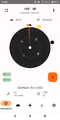
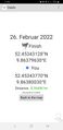
| Sat 26 Feb 2022 in 52,9: 52.4534313, 9.8637963 geohashing.info google osm bing/os kml crox |
Location
This Geohash is located in next to a path outside the golf course in Isernhagen.
Participants
- Fippe
- DLichti
- A friend
- GeorgDerReisende
Plans
Meeting at the central train station at 10:00, taking a tram to Altwarmbüchen, a bus to Lohne, and walking the rest.
GeorgDerReisende
The first announcement was for 16:00 and my plan was to be there at that time.
Expedition
DLichti
I set out at 9:00 to meet the others at Hannover Main Station. Unfortunately, we missed the 10:08 train which would have connected to the bus to Lohne. So we took the next one and walked from Altwarmbüchen terminal station. The weather was very nice, fresh, but dry and sunny.
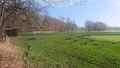
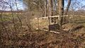
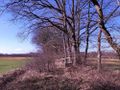
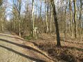
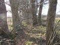
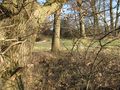
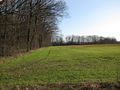
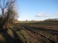
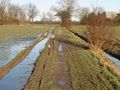
First, heading north until we came to the Alter Postweg (Old Mail Road) taking us to the north-east. We came by an equestrian center, a blueberry farm, and a camping site on a small lake. The road turned into a nice old sett pavement through the forest. Short after a freeway overpass, we had to turn onto a small path along the back of the golf course.
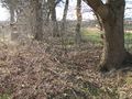
As is often the case around golf courses, there were a lot a golf balls on the ground. (But also a sign warning about golf balls in the air.) So we started collecting them and ended up with a considerable amount each of us. Unfortunately, there was no number 7 ball among them.
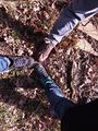
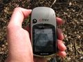
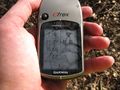
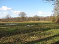
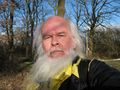
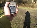
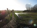
All of a sudden, we had reached the location. It was between two fields right behind the golf course. Quite easy to reach, in principle, but all attempts to achieve a <1m distance reading on our phones' GPS lead us right into a pointy scrub. We took some pictures of the environment, of ourselves as well as our golf ball collection.
To take the bus in Lohne, we would have to run or wait for quite some time. So we decided to walk the same way back to Altwarmbüchen, where we took the next tram into town. Fippe left us on the way to change to another train, while a friend and I continued to my place for a late lunch. It was a nice spring day, and we had a good time all together.
Fippe
We met at the central train station and took the tram to Altwarmbüchen, and walked the rest of the distance. DLichti's friend turned out to be a Ninja Geohasher who had been geohashing while stationed at Neumayer-Station III, Antarctica (! - details at 2019-02-28 -70 -8) as a meteorologist. I was very impressed.
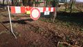
The golf players had littered the ditch next to the path we took with golf balls, which we took as souvenirs. This was the same path I took to 2019-06-04 52 9. Back then I photographed a sign warning people of flying golf balls which is very close to the destination this time, and it was still there. The Geohash was nearby, and we located the coordinates.
Afterwards, we walked back to Altwarmbüchen and took the tram back. I had a good time too, it was a nice expedition.
GeorgDerReisende
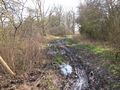
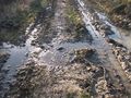
I left home at 8:20 and took the bus to Ihringshausen. There I got the train to Göttingen. But this train got a defect at Hann. Münden and most of the passengers took a train to Eichenberg for waiting for another train there. I took a bus to Göttingen. Then a train to Hannover, the light rail and a bus to Isernhagen. I walked to the hash, got the coordinates and waited for my friends. Nobody came. I wondered why. At 16:15 I left the site and took the way to Kirchhorst. In the beginning it was easy to walk, but on the last half, there were some passages, where I walked ankle-deep in the mud. The fourth of five was the worst. And I thought, this could be a reason, which hindered my friends to come.
Photos
DLichti
At night, this is a toad road.
A camping site with mini golf course.
The real golf course.
The approximate location.
proof
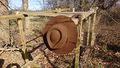
The hat was there.
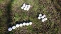
Golf ball collection.


Fippe

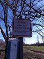
Beware of the flying golf balls
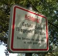
The same sign in 2019.
Proof
The Geohash
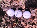
Some of the golf balls
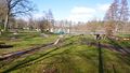
The site of the Geohash


GeorgDerReisende
entrance to the golf court hiking trail
first muddy passage
arrived - proof
proof 2
looking west
north
east
south
GeorgDerReisende
the geohash
being there at hash o'clock
now leaving, easy looking way
the first mud on my way home
the second and the third mud
looking back - is looking fine?


Ribbons
DLichti, a friend and Fippe earned the Land geohash achievement
|
DLichti, a friend and Fippe earned the Meet-up achievement
|
Fippe earned the Déjà Vu Geohash Achievement
|
DLichti earned the xkcd Nullaturion achievement
|
Fippe earned the xkcd Triginturion achievement
|
GeorgDerReisende earned the xkcd Septaginturion achievement
|