Difference between revisions of "2022-05-01 48 14"
m (Location) |
(report added) |
||
| Line 19: | Line 19: | ||
== Expedition == | == Expedition == | ||
| − | + | ||
| + | After visiting lia‘s parent for lunch and coffee/cakes, [[User:Pah|pah]] [[File:U+110DB.png|middle|6px|link=User:Pah]] and lia took a small detour on their way back to Linz to visit today‘s hashpoint, which was indeed locked in a small forest close to Reitling, [[wikipedia:Wartberg ob der Aist|Wartbert ob der Aist]]. After a short walk on the side of a field, they entered the forest and could basically walk directly towards the hash for the remaining 100m. | ||
| + | |||
| + | The only obstacle on their path was a small creek, which they could cross with an very elegant jump. The following [[The Dance™| Dance™]] in the forest took longer than expected, until pah finally locked in a good GPS reading right on the middle of the small path they encountered on the other side of the creek. Maybe the dance could have been avoided entirely by just waiting for the GPS to settle… | ||
| + | |||
| + | pah captured the proof, marked the spot, recorded the [[:Category:Grins|grin™]] and they took some pictures of the surroundings. On their way back to the car, saw a family of deer in the distance and took a minor detour before driving back home to Linz. What an easy and enjoyable expedition it was! | ||
== Tracklog == | == Tracklog == | ||
| − | + | ||
| + | {{tracklog | 2022-05-01 48 14 pah tracklog.gpx}} | ||
| + | [[Image:{{{image| 2022-05-01 48 14 pah tracklog.jpg}}}|640px]] | ||
== Photos == | == Photos == | ||
| − | |||
| − | |||
| − | |||
| − | |||
| − | |||
| − | + | [[Image:{{{image| 2022-05-01 48 14 pah 009.jpeg}}}|800px]] | |
| − | {{ | ||
| − | |||
| − | [[Category: | + | <gallery perrow="5"> |
| + | Image:2022-05-01 48 14 pah 001.jpeg | Hashmobile and final planning | ||
| + | Image:2022-05-01 48 14 pah 002.jpeg | Crossing a creek towards the hash | ||
| + | Image:2022-05-01 48 14 pah 003.jpeg | [[The Dance™]] | ||
| + | Image:2022-05-01 48 14 pah 004.jpeg | On the path anyway… | ||
| + | Image:2022-05-01 48 14 pah 005.png | Proof #1 | ||
| + | Image:2022-05-01 48 14 pah 006.png | Proof #2 | ||
| + | Image:2022-05-01 48 14 pah 007.jpeg | Preparing the hash marker | ||
| + | Image:2022-05-01 48 14 pah 008.jpeg | [[:Category:Grins|Stupid grin™]] | ||
| + | Image:2022-05-01 48 14 pah 009.jpeg | Hash panorama | ||
| + | Image:2022-05-01 48 14 pah 010.jpeg | Back to the hashmobile | ||
| − | < | + | </gallery> |
| − | |||
[[Category:Expeditions]] | [[Category:Expeditions]] | ||
| − | |||
[[Category:Expeditions with photos]] | [[Category:Expeditions with photos]] | ||
| − | |||
| − | |||
| − | |||
| − | |||
| − | |||
[[Category:Coordinates reached]] | [[Category:Coordinates reached]] | ||
| − | |||
| − | |||
| − | |||
| − | |||
| − | |||
| − | |||
| − | |||
| − | |||
| − | |||
| − | |||
| − | |||
| − | |||
| − | |||
| − | |||
| − | |||
| − | |||
| − | |||
| − | |||
{{location|AT|OÖ|FR}} | {{location|AT|OÖ|FR}} | ||
Revision as of 18:43, 1 May 2022
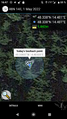
| Sun 1 May 2022 in 48,14: 48.3383708, 14.4810312 geohashing.info google osm bing/os kml crox |
Location
In a small forest near Reitling, Wartbert ob der Aist.
Participants
Plans
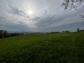
pah and lia plan to visit the hash during early afternoon and enjoy a nice Sunday walk along the Aist river during spring time afterwards.
Expedition
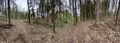
After visiting lia‘s parent for lunch and coffee/cakes, pah ![]() and lia took a small detour on their way back to Linz to visit today‘s hashpoint, which was indeed locked in a small forest close to Reitling, Wartbert ob der Aist. After a short walk on the side of a field, they entered the forest and could basically walk directly towards the hash for the remaining 100m.
and lia took a small detour on their way back to Linz to visit today‘s hashpoint, which was indeed locked in a small forest close to Reitling, Wartbert ob der Aist. After a short walk on the side of a field, they entered the forest and could basically walk directly towards the hash for the remaining 100m.
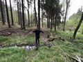
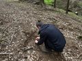
The only obstacle on their path was a small creek, which they could cross with an very elegant jump. The following Dance™ in the forest took longer than expected, until pah finally locked in a good GPS reading right on the middle of the small path they encountered on the other side of the creek. Maybe the dance could have been avoided entirely by just waiting for the GPS to settle…
pah captured the proof, marked the spot, recorded the grin™ and they took some pictures of the surroundings. On their way back to the car, saw a family of deer in the distance and took a minor detour before driving back home to Linz. What an easy and enjoyable expedition it was!
Tracklog

Photos

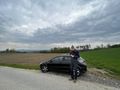
Hashmobile and final planning
Crossing a creek towards the hash
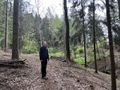
On the path anyway…
Proof #1

Proof #2
Preparing the hash marker
Hash panorama
Back to the hashmobile


