Difference between revisions of "2022-06-11 46 -123"
Michael5000 (talk | contribs) (→Photos) |
m (Location) |
||
| (5 intermediate revisions by one other user not shown) | |||
| Line 1: | Line 1: | ||
| − | + | {{meetup graticule | |
| − | |||
| − | |||
| − | |||
| − | |||
| − | |||
| − | |||
| − | |||
| − | |||
| lat={{#explode:{{SUBPAGENAME}}| |1}} | | lat={{#explode:{{SUBPAGENAME}}| |1}} | ||
| lon={{#explode:{{SUBPAGENAME}}| |2}} | | lon={{#explode:{{SUBPAGENAME}}| |2}} | ||
| Line 14: | Line 6: | ||
__NOTOC__ | __NOTOC__ | ||
== Location == | == Location == | ||
| − | + | ||
| + | On Altoona-Pillar Rock Road. | ||
== Participants == | == Participants == | ||
| − | |||
| − | |||
| − | + | [[User:Michael5000|Michael5000]] | |
| − | |||
== Expedition == | == Expedition == | ||
| − | |||
| − | + | I stopped for gas in Longview after [[2022-06-11 46 -122]] and, while stopped, I decided to take a closer look and see if the photos I had been taking really looked fuzzy. When I turned my phone on, the whole DISPLAY looked fuzzy. Uh oh. I slipped off the protective case, and saw that rain from [[2022-06-10 45 -122|yesterday's wet expedition]] had seeped inside; and when I took off the back panel there was considerable moisture inside the phone as well. | |
| − | + | ||
| + | I left the case open to dry while I drove down the Columbia on Washington Highway 4, but by the time I neared the hashpoint it was looking like I was the proud owner of a zombie phone. Altoona-Pillar Rock Road sweeps over Grays River in a high arched bridge and then eventually comes back to run along it; I parked a few hundred feet from the hashpoint and then spent 15 minutes or so trying to cajole the phone back to life. It was not interested in coming back to life. | ||
| + | |||
| + | So, I got out and strolled down to the hashpoint. A backhoe is parked on the north side of the road and the lot is being cleared for some reason; it didn't seem like a place you'd put a new house, but what do I know? There's a farmhouse to the south; an Amazon truck trundled up with a package while I stood there feeling like the mission was incomplete, because I had no way of taking pictures. | ||
| + | |||
| + | Finally, I decided that if I didn't have a camera at the hashpoint, I would have to bring the hashpoint to a camera. So, I plucked a dead cedar sprig that hanging from a branch overhanging the road shoulder, and headed back to the car. Twenty-four hours later, the picture below would be the first picture taken with my new phone. | ||
| + | |||
| + | I continued on to Astoria, where I went for a run on their waterfront trail, which turned out to be rather terrific. At 4.25 miles, it was my record for a run in Clatsop County -- running in the US states and the Oregon counties is an excellent companion hobby to geohashing. | ||
| + | |||
| + | And then I went home! | ||
== Photos == | == Photos == | ||
| − | + | ||
| − | |||
| − | |||
<gallery perrow="5"> | <gallery perrow="5"> | ||
| − | File:2022-06-11 46 -123 a.jpg| | + | File:2022-06-11 46 -123 a.jpg|A cedar sprig from the hashpoint, photographed the next day at my kitchen table. |
</gallery> | </gallery> | ||
== Achievements == | == Achievements == | ||
{{#vardefine:ribbonwidth|800px}} | {{#vardefine:ribbonwidth|800px}} | ||
| − | |||
| − | + | I believe this is the first expedition and first successful expedition, by anyone, to Wahkiakum County, Washington. | |
| − | + | {{Regional geohashing | |
| − | + | | name = Michael5000 | |
| + | | region = Wahkiakum County, Washington | ||
| + | | count = 1 | ||
| + | | image = 2022-06-12 46 -123 County.jpg | ||
| + | }} | ||
| + | |||
| − | + | {{consecutive geohash | |
| − | + | | count = 2 | |
| − | + | | latitude = 45 | |
| − | + | | longitude = -122 | |
| − | + | | date = 2022-06-10 | |
| + | | name = Michael5000 | ||
| − | + | }} | |
| − | + | {{Multihash | |
| − | |||
| − | |||
| − | |||
| − | |||
| − | |||
| − | |||
| − | |||
| − | |||
| − | |||
| + | | latitude1 = 46 | ||
| + | | longitude1 = -122 | ||
| + | | latitude2 = 46 | ||
| + | | longitude2 = -123 | ||
| + | | date = 2022-06-11 | ||
| + | | name = Michael5000 | ||
| − | |||
| − | |||
| − | |||
| − | |||
| − | |||
| − | |||
| − | |||
| − | |||
| − | + | }} | |
| − | |||
| − | |||
| − | |||
| − | |||
| − | + | [[Category:Expeditions]] | |
| + | [[Category:Expeditions with photos]] | ||
| + | [[Category:Coordinates reached]] | ||
| + | {{location|US|WA|WH}} | ||
Latest revision as of 23:42, 12 June 2022
| Sat 11 Jun 2022 in 46,-123: 46.3065811, -123.6711348 geohashing.info google osm bing/os kml crox |
Location
On Altoona-Pillar Rock Road.
Participants
Expedition
I stopped for gas in Longview after 2022-06-11 46 -122 and, while stopped, I decided to take a closer look and see if the photos I had been taking really looked fuzzy. When I turned my phone on, the whole DISPLAY looked fuzzy. Uh oh. I slipped off the protective case, and saw that rain from yesterday's wet expedition had seeped inside; and when I took off the back panel there was considerable moisture inside the phone as well.
I left the case open to dry while I drove down the Columbia on Washington Highway 4, but by the time I neared the hashpoint it was looking like I was the proud owner of a zombie phone. Altoona-Pillar Rock Road sweeps over Grays River in a high arched bridge and then eventually comes back to run along it; I parked a few hundred feet from the hashpoint and then spent 15 minutes or so trying to cajole the phone back to life. It was not interested in coming back to life.
So, I got out and strolled down to the hashpoint. A backhoe is parked on the north side of the road and the lot is being cleared for some reason; it didn't seem like a place you'd put a new house, but what do I know? There's a farmhouse to the south; an Amazon truck trundled up with a package while I stood there feeling like the mission was incomplete, because I had no way of taking pictures.
Finally, I decided that if I didn't have a camera at the hashpoint, I would have to bring the hashpoint to a camera. So, I plucked a dead cedar sprig that hanging from a branch overhanging the road shoulder, and headed back to the car. Twenty-four hours later, the picture below would be the first picture taken with my new phone.
I continued on to Astoria, where I went for a run on their waterfront trail, which turned out to be rather terrific. At 4.25 miles, it was my record for a run in Clatsop County -- running in the US states and the Oregon counties is an excellent companion hobby to geohashing.
And then I went home!
Photos
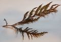
A cedar sprig from the hashpoint, photographed the next day at my kitchen table.

Achievements
I believe this is the first expedition and first successful expedition, by anyone, to Wahkiakum County, Washington.
Michael5000 earned the Regional geohashing achievement
|
Michael5000 earned the Consecutive geohash achievement
|
Michael5000 earned the Multihash Achievement
|