Difference between revisions of "2022-07-26 45 -122"
From Geohashing
Michael5000 (talk | contribs) (→Location) |
(can't see any videos) |
||
| (4 intermediate revisions by 2 users not shown) | |||
| Line 1: | Line 1: | ||
| − | + | {{meetup graticule | |
| − | |||
| − | |||
| − | |||
| − | |||
| − | |||
| − | |||
| − | |||
| − | |||
| lat={{#explode:{{SUBPAGENAME}}| |1}} | | lat={{#explode:{{SUBPAGENAME}}| |1}} | ||
| lon={{#explode:{{SUBPAGENAME}}| |2}} | | lon={{#explode:{{SUBPAGENAME}}| |2}} | ||
| Line 15: | Line 7: | ||
== Location == | == Location == | ||
| − | On 31st Avenue in | + | On 31st Avenue in Eastmoreland. |
== Participants == | == Participants == | ||
| − | |||
| − | |||
| − | + | *[[User:Michael5000|Michael5000]] | |
| − | |||
== Expedition == | == Expedition == | ||
| − | |||
| − | + | I recently remembered that I have a bicycle and have been riding it a little bit, so this easy-peasy hashpoint a few miles south of home was an terrific candidate for the first all-biking expedition in, like, eleven years. After work I took a little siesta, it being a bit hot, and then woke up and rode down to the pretty, genteel neighborhood of Eastmoreland. After that, I rode home, 8.8 miles for the round trip. It was fun. | |
| − | |||
== Photos == | == Photos == | ||
| − | + | ||
| − | |||
| − | |||
<gallery perrow="5"> | <gallery perrow="5"> | ||
| + | File:2022-07-26 45 -122 a.jpg|View from the hashpoint | ||
| + | File:2022-07-26 45 -122 b.jpg|Me, at hashpoint | ||
| + | File:2022-07-26 45 -122 c.jpg|Dashboard shot | ||
| + | File:2022-07-26 45 -122 d.jpg|Good ol' app | ||
</gallery> | </gallery> | ||
== Achievements == | == Achievements == | ||
{{#vardefine:ribbonwidth|800px}} | {{#vardefine:ribbonwidth|800px}} | ||
| − | |||
| − | + | {{bicycle geohash | |
| − | |||
| − | |||
| − | + | | latitude = 45 | |
| + | | longitude = -122 | ||
| + | | date = 2022-07-26 | ||
| + | | name = Michael5000 | ||
| + | | distance = 8.8 miles | ||
| + | | bothways = true | ||
| + | | image = 2022-07-26 45 -122 c.jpg | ||
| − | + | }} | |
| − | |||
| − | |||
| − | |||
| − | + | *At 95 F, a fairly ~hot~ expedition. | |
| − | |||
[[Category:Expeditions]] | [[Category:Expeditions]] | ||
| − | + | ||
[[Category:Expeditions with photos]] | [[Category:Expeditions with photos]] | ||
| − | |||
| − | |||
| − | |||
| − | |||
| − | |||
[[Category:Coordinates reached]] | [[Category:Coordinates reached]] | ||
| − | + | {{location|US|OR|MU}} | |
| − | |||
| − | |||
| − | |||
| − | |||
| − | |||
| − | |||
| − | |||
| − | |||
| − | |||
| − | |||
| − | |||
| − | |||
| − | |||
| − | |||
| − | |||
| − | |||
| − | |||
Latest revision as of 14:57, 24 October 2022
| Tue 26 Jul 2022 in 45,-122: 45.4687567, -122.6313732 geohashing.info google osm bing/os kml crox |
Location
On 31st Avenue in Eastmoreland.
Participants
Expedition
I recently remembered that I have a bicycle and have been riding it a little bit, so this easy-peasy hashpoint a few miles south of home was an terrific candidate for the first all-biking expedition in, like, eleven years. After work I took a little siesta, it being a bit hot, and then woke up and rode down to the pretty, genteel neighborhood of Eastmoreland. After that, I rode home, 8.8 miles for the round trip. It was fun.
Photos
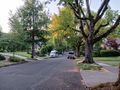
View from the hashpoint
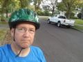
Me, at hashpoint
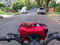
Dashboard shot
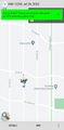
Good ol' app


Achievements
Michael5000 earned the Bicycle geohash achievement
|
- At 95 F, a fairly ~hot~ expedition.