Difference between revisions of "2023-02-19 45 -122"
Michael5000 (talk | contribs) (Created page with "{{subst:Expedition}}") |
m (Location) |
||
| (5 intermediate revisions by one other user not shown) | |||
| Line 13: | Line 13: | ||
}}<!-- edit as necessary --> | }}<!-- edit as necessary --> | ||
== Location == | == Location == | ||
| − | + | ||
| + | By Beaverton Creek in Tualatin Hills Nature Park. | ||
== Participants == | == Participants == | ||
| − | + | *[[user:Michael5000|Michael5000]] | |
| − | |||
| − | |||
| − | |||
| − | |||
== Expedition == | == Expedition == | ||
| − | + | On the map, this one looked like it would be too marshy to get to, but I've never been to the Tualatin Hills Nature Park and was curious about it. So I drove out and then went for a run that was partly in the Park, and also built in a stretch of the run I used to take back when I occasionally worked out in this area. | |
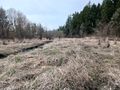
| − | + | On the run, I saw that the creek bottom was not as marshy as it might have been, so I changed into a dry top and garden clogs back at the truck, and then followed trails to within a few hundred meters of the hashpoint. From there, I had to fight through a little bit of forest down to the floodplain, which still looked like it could be treacherous and boggy. But actually, I was pretty much able to walk on top of a layer of last year's dead grasses all the way to the hashpoint. It's always nice to finish an expedition with dry feet, especially in February. | |
| − | |||
== Photos == | == Photos == | ||
| − | + | ||
| − | |||
| − | |||
<gallery perrow="5"> | <gallery perrow="5"> | ||
| + | File:2023-02-19 45 -122 1.jpg|Sign at the park entrance | ||
| + | File:2023-02-19 45 -122 2.jpg|Interpretation! | ||
| + | File:2023-02-19 45 -122 3.jpg|The main trail in passes through a little community center | ||
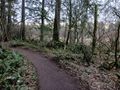
| + | File:2023-02-19 45 -122 4.jpg|Turning left off the main trail... | ||
| + | File:2023-02-19 45 -122 5.jpg|From this point I'd need to leave the trail to the right and down. | ||
| + | File:2023-02-19 45 -122 6.jpg|Looking downstream from the hashpoint. | ||
| + | File:2023-02-19 45 -122 7.jpg|Looking upstream from the hashpoint. | ||
| + | File:2023-02-19 45 -122 8.jpg|Ta da! | ||
</gallery> | </gallery> | ||
| Line 40: | Line 42: | ||
__NOTOC__ | __NOTOC__ | ||
| − | |||
| − | |||
| − | |||
| − | |||
| − | |||
| − | |||
| − | |||
| − | |||
| − | |||
| − | |||
| − | |||
| − | |||
| − | |||
[[Category:Expeditions]] | [[Category:Expeditions]] | ||
| − | |||
[[Category:Expeditions with photos]] | [[Category:Expeditions with photos]] | ||
| − | |||
| − | |||
| − | |||
| − | |||
| − | |||
[[Category:Coordinates reached]] | [[Category:Coordinates reached]] | ||
| − | + | {{location|US|OR|WI}} | |
| − | |||
| − | |||
| − | |||
| − | |||
| − | |||
| − | |||
| − | |||
| − | |||
| − | |||
| − | |||
| − | |||
| − | |||
| − | |||
| − | |||
| − | |||
| − | |||
| − | |||
Latest revision as of 15:42, 20 February 2023
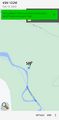
| Sun 19 Feb 2023 in 45,-122: 45.4963914, -122.8446142 geohashing.info google osm bing/os kml crox |
Location
By Beaverton Creek in Tualatin Hills Nature Park.
Participants
Expedition
On the map, this one looked like it would be too marshy to get to, but I've never been to the Tualatin Hills Nature Park and was curious about it. So I drove out and then went for a run that was partly in the Park, and also built in a stretch of the run I used to take back when I occasionally worked out in this area.
On the run, I saw that the creek bottom was not as marshy as it might have been, so I changed into a dry top and garden clogs back at the truck, and then followed trails to within a few hundred meters of the hashpoint. From there, I had to fight through a little bit of forest down to the floodplain, which still looked like it could be treacherous and boggy. But actually, I was pretty much able to walk on top of a layer of last year's dead grasses all the way to the hashpoint. It's always nice to finish an expedition with dry feet, especially in February.
Photos
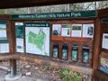
Sign at the park entrance
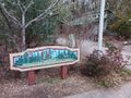
Interpretation!
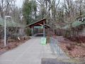
The main trail in passes through a little community center
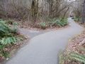
Turning left off the main trail...
From this point I'd need to leave the trail to the right and down.
Looking downstream from the hashpoint.
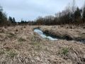
Looking upstream from the hashpoint.
Ta da!


