Difference between revisions of "2023-09-08 -34 138"
(expedition plan) |
m (Location) |
||
| (3 intermediate revisions by 2 users not shown) | |||
| Line 14: | Line 14: | ||
== Location == | == Location == | ||
<!-- where you've surveyed the hash to be --> | <!-- where you've surveyed the hash to be --> | ||
| − | Dequetteville Terrace, Kent Town ( | + | Dequetteville Terrace, Kent Town (in some sort of apartment complex) |
== Participants == | == Participants == | ||
| Line 29: | Line 29: | ||
== Expedition == | == Expedition == | ||
<!-- how it all turned out. your narrative goes here. --> | <!-- how it all turned out. your narrative goes here. --> | ||
| + | I started out at about 12:20 from university, after having lunch. I briefly stopped at the closest Hungry Jack's, which is [https://www.calcmaps.com/map-distance/s0pkff/ just within 1km] of the hash, before walking that ~1km distance to the hash. | ||
| + | |||
| + | The actual point was located, I quickly found out, in the carpark of an apartment complex. I first attempted to see if I could somehow enter the lobby of the building, to see if it was possible to access the carpark even though I don't live there or know anyone who does, but all of the entrances required someone who actually lives there to let you in. | ||
| + | |||
| + | Thankfully, there was a weird construction entrance (or something) that allowed me to get ''next'' to the private carpark without actually entering it, and that was enough to get the hash in the GPS error radius. | ||
== Tracklog == | == Tracklog == | ||
| + | Please note that the tracklog got a bit messed up around Hungry Jack's. | ||
| + | |||
<!-- if your GPS device keeps a log, you may use Template:Tracklog, post a link here, or both --> | <!-- if your GPS device keeps a log, you may use Template:Tracklog, post a link here, or both --> | ||
| + | {{Tracklog|2023-09-08 -34 138 XXOs.gpx}} | ||
== Photos == | == Photos == | ||
| Line 38: | Line 46: | ||
--> | --> | ||
<gallery perrow="5"> | <gallery perrow="5"> | ||
| + | Image:2023-09-08 -34 138 geosquishy.jpeg | [[GeoSquishy]] obtained! | ||
| + | Image:2023-09-08 -34 138 geosquishy receipt.png | ...plus the reciept | ||
| + | Image:2023-09-08 -34 138 so close.jpeg | The location of the hash was annoyingly behind this gate :( | ||
| + | Image:2023-09-08 -34 138 google maps.png | Location + time proof (Google Maps) | ||
| + | Image:2023-09-08 -34 138 watch.jpeg | Time + date proof (watch) | ||
| + | Image:2023-09-08 -34 138 grin 1.jpg | At the hash, with a very melted one-third-of-a-[[GeoSquishy]]! | ||
| + | Image:2023-09-08 -34 138 grin 2.jpg | (Alternate angle that actually shows the main apartment building) | ||
</gallery> | </gallery> | ||
| Line 43: | Line 58: | ||
{{#vardefine:ribbonwidth|100%}} | {{#vardefine:ribbonwidth|100%}} | ||
<!-- Add any achievement ribbons you earned below, or remove this section --> | <!-- Add any achievement ribbons you earned below, or remove this section --> | ||
| + | {{Walk geohash | latitude = -34 | longitude = 138 | date = 2023-09-08 | name = [[User:XXOs|XXOs]]}} | ||
| + | {{Two to the N achievement | count = 2 | date = 2023-09-08 | latitude = -34 | longitude = 138 | name = [[User:XXOs|XXOs]] | reached = true }} | ||
| + | {{consecutive geohash | count = 2 | latitude = -34 | longitude = 138 | date = 2023-09-07 | name = [[User:XXOs|XXOs]] }} | ||
| + | {{GeoSquishy FirstSip | latitude = -34 | longitude = 138 | date = 2023-09-08 | name = [[User:XXOs|XXOs]] | image = 2023-09-08 -34 138 grin 2.jpg }} | ||
| + | {{GeoSquishy 5Star | latitude = -34 | longitude = 138 | date = 2023-09-08 | name = [[User:XXOs|XXOs]] | image = 2023-09-08 -34 138 grin 2.jpg }} | ||
__NOTOC__ | __NOTOC__ | ||
| − | |||
| − | |||
| − | |||
| − | |||
| − | |||
| − | |||
| − | |||
| − | |||
| − | |||
| − | |||
| − | |||
| − | |||
[[Category:Expeditions]] | [[Category:Expeditions]] | ||
| − | |||
[[Category:Expeditions with photos]] | [[Category:Expeditions with photos]] | ||
| − | |||
| − | |||
| − | |||
| − | |||
| − | |||
[[Category:Coordinates reached]] | [[Category:Coordinates reached]] | ||
| − | + | {{location|AU|SA|NP}} | |
| − | |||
| − | |||
| − | |||
| − | |||
| − | |||
| − | |||
| − | |||
| − | |||
| − | |||
| − | |||
| − | |||
| − | |||
| − | |||
| − | |||
| − | |||
| − | |||
| − | |||
Latest revision as of 21:42, 9 September 2023
| Fri 8 Sep 2023 in -34,138: -34.9223781, 138.6164133 geohashing.info google osm bing/os kml crox |
Location
Dequetteville Terrace, Kent Town (in some sort of apartment complex)
Participants
Plans
Today's hash is even easier than yesterday's - it's within 20 minutes' walking distance of where I am for most of the day!
I'm probably also going to stop off at the Rundle Street Hungry Jack's, which is just within 1km of the hash (for the GeoSquishy Achievement).
Expedition
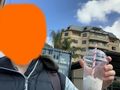
I started out at about 12:20 from university, after having lunch. I briefly stopped at the closest Hungry Jack's, which is just within 1km of the hash, before walking that ~1km distance to the hash.
The actual point was located, I quickly found out, in the carpark of an apartment complex. I first attempted to see if I could somehow enter the lobby of the building, to see if it was possible to access the carpark even though I don't live there or know anyone who does, but all of the entrances required someone who actually lives there to let you in.
Thankfully, there was a weird construction entrance (or something) that allowed me to get next to the private carpark without actually entering it, and that was enough to get the hash in the GPS error radius.
Tracklog
Please note that the tracklog got a bit messed up around Hungry Jack's.
Photos
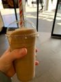
GeoSquishy obtained!

...plus the reciept
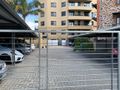
The location of the hash was annoyingly behind this gate :(
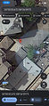
Location + time proof (Google Maps)
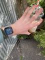
Time + date proof (watch)

At the hash, with a very melted one-third-of-a-GeoSquishy!
(Alternate angle that actually shows the main apartment building)


Achievements
XXOs earned the Walk geohash Achievement
|

XXOs earned the Consecutive geohash achievement
|
XXOs earned the First Sip GeoSquishy Achievement
|
XXOs earned the 5 Star GeoSquishy Achievement
|