Difference between revisions of "2024-02-25 49 8"
m (Location) |
Green guy! (talk | contribs) (Add witty captions to gallery) |
||
| (One intermediate revision by the same user not shown) | |||
| Line 36: | Line 36: | ||
== Photos == | == Photos == | ||
| − | |||
| − | |||
| − | |||
| − | |||
<gallery> | <gallery> | ||
| − | File:2024-02-25 49 8 Trip 01 Bürgerhaus Traisa 1 Recipe for Joy.jpg | + | File:2024-02-25 49 8 Trip 01 Bürgerhaus Traisa 1 Recipe for Joy.jpg | ''Recipe for Joy'', found on the wall in the restaurant’s entrance area <small>(click on image to read full transcription)</small> |
| − | File:2024-02-25 49 8 Trip 01 Bürgerhaus Traisa 2 Chicken sweet-and-sour.jpg | + | File:2024-02-25 49 8 Trip 01 Bürgerhaus Traisa 2 Chicken sweet-and-sour.jpg | My lunch: chicken breast filet “sweet-and-sour” with apricot-pineapple sauce, plus rice and (on the top-left) a colorful side salad |
| − | File:2024-02-25 49 8 Trip 01 Bürgerhaus Traisa 3 Chicken sweet-and-sour done.jpg | + | File:2024-02-25 49 8 Trip 01 Bürgerhaus Traisa 3 Chicken sweet-and-sour done.jpg | I never eat this large of a serving size, so this is how much remained when I was full. Don’t worry about wasting food, as we always take away surpluses if possible. |
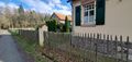
| − | File:2024-02-25 49 8 Trip 02 Forsthaus Eiserne Hand.jpg | + | File:2024-02-25 49 8 Trip 02 Forsthaus Eiserne Hand.jpg | Looking northwest from ''[https://www.openstreetmap.org/way/23403837 Alte Ober-Ramstädter Straße]'' onto ''[https://www.openstreetmap.org/way/71283876 Forsthaus »Eiserne Hand«]'' and the [https://www.openstreetmap.org/way/1255286066 meadow] next to it |
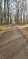
| − | File:2024-02-25 49 8 Trip 03.jpg | + | File:2024-02-25 49 8 Trip 03.jpg | Going north; there is a caravan in the distance |
| − | File:2024-02-25 49 8 Trip 04.jpg | + | File:2024-02-25 49 8 Trip 04.jpg | Still going north; slight-right turn upcoming |
| − | File:2024-02-25 49 8 Trip 05 Beautiful sunshine in forest.jpg | + | File:2024-02-25 49 8 Trip 05 Beautiful sunshine in forest.jpg | Sun shining between the trees: so beautiful … |
| − | File:2024-02-25 49 8 Trip 06 man_made=insect_hotel.jpg | + | File:2024-02-25 49 8 Trip 06 man_made=insect_hotel.jpg | An [https://www.openstreetmap.org/node/11669369894 insect hotel]; photo taken for OpenStreetMap mapping |
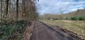
| − | File:2024-02-25 49 8 Trip 07.jpg | + | File:2024-02-25 49 8 Trip 07.jpg | Going northeast on [https://www.openstreetmap.org/way/144995287 Hanum-Schneise], approaching the hashpoint |
| − | File:2024-02-25 49 8 OruxMaps Coordinates.png | + | File:2024-02-25 49 8 OruxMaps Coordinates.png | Hashpoint coordinates reached in OruxMaps |
| − | File:2024-02-25 49 8 looking at nature reserve sign shard.jpg | + | File:2024-02-25 49 8 looking at nature reserve sign shard.jpg | Shard of a nature reserve sign at the hashpoint |
| − | File:2024-02-25 49 8 looking northeast.jpg | + | File:2024-02-25 49 8 looking northeast.jpg | Looking northeast at the hashpoint which lies right ahead |
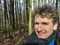
| − | File:2024-02-25 49 8 funny grin 1.jpg | + | File:2024-02-25 49 8 funny grin 1.jpg | Funny grin; you can tell how joyful I am! |
| − | File:2024-02-25 49 8 funny grin 2.jpg | + | File:2024-02-25 49 8 funny grin 2.jpg | Fun fact: The white thingies in my ears are puffs of cotton – I almost always wear them outdoors to dampen environmental noises (providing for the risk of unexpected loud noise) because I am really sensitive as an autist. |
| − | File:2024-02-25 49 8 funny grin 3.jpg | + | File:2024-02-25 49 8 funny grin 3.jpg | Frog perspective of my face; look at the trees converging towards the sky |
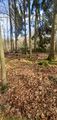
| − | File:2024-02-25 49 8 Trip 08 Nature reserve 1.jpg | + | File:2024-02-25 49 8 Trip 08 Nature reserve 1.jpg | Looking northwest at nature reserve ''[https://www.openstreetmap.org/relation/12270262 Großer und kleiner Bruch bei Roßdorf]'' |
| − | File:2024-02-25 49 8 Trip 08 Nature reserve 2 sign.jpg | + | File:2024-02-25 49 8 Trip 08 Nature reserve 2 sign.jpg | [https://www.openstreetmap.org/node/8390487215 Signposting]: “Nature reserve area” |
| − | File:2024-02-25 49 8 Trip 09 Diebsbrunnen 1.jpg | + | File:2024-02-25 49 8 Trip 09 Diebsbrunnen 1.jpg | [https://www.openstreetmap.org/node/1585357761 ''Diebsbrunnen'' spring] with inscription on the left <small>(click on image to read full transcription)</small> |
| − | File:2024-02-25 49 8 Trip 09 Diebsbrunnen 2.jpg | + | File:2024-02-25 49 8 Trip 09 Diebsbrunnen 2.jpg | A [https://www.openstreetmap.org/node/5249408530 bench] on the left and a stream on the right, which is springing up from the ''Diebsbrunnen'' (“Thief’s Well”) |
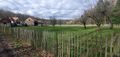
| − | File:2024-02-25 49 8 Trip 10.jpg | + | File:2024-02-25 49 8 Trip 10.jpg | Looking south onto meadow |
| − | File:2024-02-25 49 8 Trip 11.jpg | + | File:2024-02-25 49 8 Trip 11.jpg | Looking west from ''[https://www.openstreetmap.org/way/144959622 Alte Dieburger Straße]'' onto meadow |
| − | File:2024-02-25 49 8 Trip 12.jpg | + | File:2024-02-25 49 8 Trip 12.jpg | Looking northwest from ''[https://www.openstreetmap.org/way/28301626 Alte Dieburger Straße]'' |
| − | File:2024-02-25 49 8 Trip 13 Joy and awe of God.jpg | + | File:2024-02-25 49 8 Trip 13 Joy and awe of God.jpg | Going west-southwest towards ''Forsthaus »Eiserne Hand«''; this is the location where I especially felt a strong joy and awe of God’s creation … Just look at it! Imagine being in this majestic beauty! <small>(This is what God intended for us humans.)</small> |
| − | File:2024-02-25 49 8 Trip 14 Forsthaus Eiserne Hand closeup.jpg | + | File:2024-02-25 49 8 Trip 14 Forsthaus Eiserne Hand closeup.jpg | Closeup of ''Forsthaus »Eiserne Hand«'', looking east |
| − | File:2024-02-25 49 8 Trip 15 Parking lot vicinity.jpg | + | File:2024-02-25 49 8 Trip 15 Parking lot vicinity.jpg | Looking southwest onto [https://www.openstreetmap.org/way/110467960 road ''Am Dippelshof'']; our car is parked on the [https://www.openstreetmap.org/way/110467977 parking lot] on the right. |
| − | File:2024-02-25 49 8 Trip 16 Naturfriedhof Mühltal 1.jpg | + | File:2024-02-25 49 8 Trip 16 Naturfriedhof Mühltal 1.jpg | Entrance to ''[https://www.openstreetmap.org/way/156830858 NaturFriedhof Mühltal]'' with [https://www.openstreetmap.org/node/11669442965 rules sign] |
| − | File:2024-02-25 49 8 Trip 16 Naturfriedhof Mühltal 2 CROPPED.jpg | + | File:2024-02-25 49 8 Trip 16 Naturfriedhof Mühltal 2 CROPPED.jpg | [https://www.openstreetmap.org/node/11669505536 Primary information and rules sign of ''NaturFriedhof Mühltal''], with a map of all the grave trees you can find there. |
</gallery> | </gallery> | ||
== Achievements == | == Achievements == | ||
| + | |||
| + | === First-time === | ||
| + | I earned these for the first time from this geohash. | ||
{{#vardefine:ribbonwidth|100%}} | {{#vardefine:ribbonwidth|100%}} | ||
{{Two to the N achievement | {{Two to the N achievement | ||
| Line 80: | Line 79: | ||
| reached = true | | reached = true | ||
}} | }} | ||
| + | {{OpenStreetMap achievement | ||
| + | | latitude = 49 | ||
| + | | longitude = 8 | ||
| + | | date = 2024-02-25 | ||
| + | | OSMlink2 = 147976631 | ||
| + | | OSMlink3 = 147977070 | ||
| + | | OSMlink = 147978293 | ||
| + | | name = [[User:Green guy!|Green guy!]] ([[User talk:Green guy!|talk]]) | ||
| + | }} | ||
| + | === Recurring === | ||
| + | I already earned these from an earlier geohash, but fulfilled the conditions again on this one. | ||
| + | {{#vardefine:ribbonwidth|100%}} | ||
| + | {{land geohash | ||
| + | | latitude = 49 | ||
| + | | longitude = 8 | ||
| + | | date = 2024-02-25 | ||
| + | | name = [[User:Green guy!|Green guy!]] ([[User talk:Green guy!|talk]]) | ||
| + | }} | ||
| + | And no, [[Drag-along achievement|drag-along]] doesn’t count as recurring because my parents are now sort-of familiar with the concept of geohashing (apart from not comprehending [[the Algorithm]]’s details). | ||
__NOTOC__ | __NOTOC__ | ||
Latest revision as of 14:44, 28 February 2024

| Sun 25 Feb 2024 in 49,8: 49.8523079, 8.7234192 geohashing.info google osm bing/os kml crox |
Location
The hashpoint lies in a forest area, about 15 meters away from the closest path, in Darmstadt-Dieburg county, Hesse, Germany; next to a nature reserve called Großer und kleiner Bruch bei Roßdorf. The two closest settlements are Traisa in south-west direction and Roßdorf in east direction.
Participants
- Green guy! (talk)
- Green guy!’s mother (no consent to publish photos of her)
- Green guy!’s father (no consent to publish photos of him)
Plans
Originally, I planned to reach the hashpoint from the north (coming from the secondary road L 3104). However, I realized that it is easier to reach from the south (coming from Traisa). Before Sunday church service at CGD (Christliche Gemeinde Darmstadt), I had just enough time to finish my plans, which included looking up good restaurants in the vicinity and planning the exact route for the expedition.
Expedition
Around 12:30 pm, after being done with this Sunday’s church service at CGD, my parents and I drove geohashing by car with no stopover at home: We took the Nieder-Ramstädter Straße (B449) headed towards – you guessed it – Nieder-Ramstadt. Then, we turned left onto a different Nieder-Ramstädter Straße which leads into the village of Traisa.
Because it was noon and we were hungry, we decided to first go to a restaurant before proceeding with the geohashing expedition. We decided on the Bürgerhaus Traisa because it was open at noon, offered an interesting-looking “sweet-and-sour chicken breast” dish and looked promising in general. The restaurant turned out to be very inviting and calm: Despite there being numerous people, it was surprisingly quiet (which was really pleasant to me as I am highly sensitive to noise). Also, the restaurant’s premises were heavily ornamented with a variety of funny and inspiring proverbs, especially on the walls.
After eating our fill, we went on driving closer to the hashpoint and parked our car on the parking lot next to the golf course of Golf-Club Darmstadt Traisa and the Naturfriedhof Mühltal, a forest graveyard.
Starting from the parking lot, we went on a clockwise walking route to the hashpoint and back to our car: The sun was shining and there were birds singing in the forest, which induced a strong joy and awe of God(learn more about Him) and His creation in me. Similar to last time, I did the routine of taking some photos upon reaching the hashpoint. All in all, it was a wonderful time and afterwards I felt satisfied and ready for the next day, including vocational school.
(PS from Monday: This week of vocational school had an amazing start and I am motivated on finishing this report.)
Tracklog
The tracklog shows my clockwise walking route (most deviations from tracks and paths are GPS inaccuracies) and all locations where I took photos. (I took a lot of photos because the scenery was so beautiful to me.)
Photos
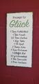
Recipe for Joy, found on the wall in the restaurant’s entrance area (click on image to read full transcription)

My lunch: chicken breast filet “sweet-and-sour” with apricot-pineapple sauce, plus rice and (on the top-left) a colorful side salad

I never eat this large of a serving size, so this is how much remained when I was full. Don’t worry about wasting food, as we always take away surpluses if possible.
Looking northwest from Alte Ober-Ramstädter Straße onto Forsthaus »Eiserne Hand« and the meadow next to it
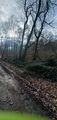
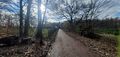
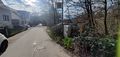
Going north; there is a caravan in the distance
Still going north; slight-right turn upcoming
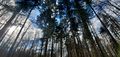
Sun shining between the trees: so beautiful …
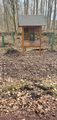
An insect hotel; photo taken for OpenStreetMap mapping
Going northeast on Hanum-Schneise, approaching the hashpoint
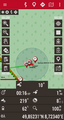
Hashpoint coordinates reached in OruxMaps
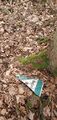
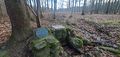
Shard of a nature reserve sign at the hashpoint
Looking northeast at the hashpoint which lies right ahead

Funny grin; you can tell how joyful I am!
Fun fact: The white thingies in my ears are puffs of cotton – I almost always wear them outdoors to dampen environmental noises (providing for the risk of unexpected loud noise) because I am really sensitive as an autist.
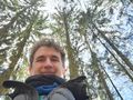
Frog perspective of my face; look at the trees converging towards the sky
Looking northwest at nature reserve Großer und kleiner Bruch bei Roßdorf
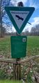
Signposting: “Nature reserve area”
Diebsbrunnen spring with inscription on the left (click on image to read full transcription)
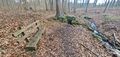
A bench on the left and a stream on the right, which is springing up from the Diebsbrunnen (“Thief’s Well”)
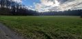
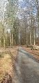
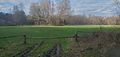
Looking south onto meadow
Looking west from Alte Dieburger Straße onto meadow
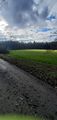
Looking northwest from Alte Dieburger Straße
Going west-southwest towards Forsthaus »Eiserne Hand«; this is the location where I especially felt a strong joy and awe of God’s creation … Just look at it! Imagine being in this majestic beauty! (This is what God intended for us humans.)
Closeup of Forsthaus »Eiserne Hand«, looking east
Looking southwest onto road Am Dippelshof; our car is parked on the parking lot on the right.
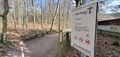
Entrance to NaturFriedhof Mühltal with rules sign
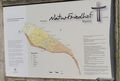
Primary information and rules sign of NaturFriedhof Mühltal, with a map of all the grave trees you can find there.


Achievements
First-time
I earned these for the first time from this geohash.

Green guy! (talk) earned the OpenStreetMap achievement
|
Recurring
I already earned these from an earlier geohash, but fulfilled the conditions again on this one.
Green guy! (talk) earned the Land geohash achievement
|
And no, drag-along doesn’t count as recurring because my parents are now sort-of familiar with the concept of geohashing (apart from not comprehending the Algorithm’s details).