Difference between revisions of "2024-03-09 45 -122"
From Geohashing
Michael5000 (talk | contribs) |
m (Location) |
||
| Line 39: | Line 39: | ||
[[Category:Expeditions with photos]] | [[Category:Expeditions with photos]] | ||
[[Category:Coordinates reached]] | [[Category:Coordinates reached]] | ||
| + | {{location|US|OR|MU}} | ||
Latest revision as of 03:42, 10 March 2024
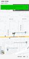
| Sat 9 Mar 2024 in 45,-122: 45.4972066, -122.4405706 geohashing.info google osm bing/os kml crox |
Location
On the sidewalk of Powell Blvd near downtown Gresham.
Participants
Expedition
Seeing a very easy hashpoint, I drove out to Gresham, parked a block or two away, and strolled over to ground zero. Then I went on a nine-mile run on the nearby Springwater Corridor trail -- the longest run I've managed in several years. I briefly revisited the hashpoint for good measure, then continued to the next mission: buying some blackberry bushes.
Photos
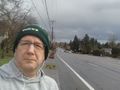
At the hashpoint, before the run.
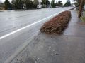
There it is! The hashpoint!
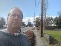
At the hashpoint, after the run.