Difference between revisions of "2024-03-17 47 -122"
Coyotebush (talk | contribs) (→Achievements) |
m (Location) |
||
| Line 126: | Line 126: | ||
[[Category:Expeditions with photos]] | [[Category:Expeditions with photos]] | ||
[[Category:Coordinates reached]] | [[Category:Coordinates reached]] | ||
| + | {{location|US|WA|KS}} | ||
Latest revision as of 19:42, 23 March 2024
| Sun 17 Mar 2024 in Seattle: 47.6140593, -122.6268826 geohashing.info google osm bing/os kml crox |
Location
Entrance to a Lowe's parking lot in East Bremerton.
Roughly a mile by road from 2017-07-29.
Participants
Plans
Light rail to downtown Seattle, ferry to Bremerton, bus to Lowe's.
Biggest schedule constraint is the ferry. On Sundays, the fast ferry I used on my previous East Bremerton expedition doesn't run, leaving Bremerton served by only a single Washington State Ferries vessel. That takes an hour each way, plus around 20 minutes to unload/load at each end. So I need to be in Bremerton for about 3 hours while the ferry makes a round trip back to Seattle. Normally I wouldn't be up for so much travel or total time, but this weekend has the warmest weather in 5 months and scenic ferry rides barely count anyway.
Route 217 is perfect for this, and coincidentally the only Kitsap Transit bus route that operates on Sundays. That stops running around 16:00, and I'd like to be home by evening anyway, so my ferry options are:
- Leave Seattle 10:00, leave Bremerton 13:30. Lunch following geohash.
- Leave Seattle 12:20, leave Bremerton 16:15. Lunch from ferry galley.
The later trip aligns better with the warmest part of the day, and allows for a leisurely morning. A hike through the Illahee Forest Preserve, right behind Lowe's, sounds like a nice way to spend the extra time.
Expedition
Another clear warm day as predicted. After a good breakfast I grabbed a hydration backpack and a book.
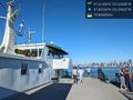
I arrived at the University Street light rail station at 11:50 and out of habit climbed the three-ish flights of stairs to the surface. Then I noticed a for-once-functional escalator leading back down; I rode it down and up just to find out where the other end was. A slightly-too-long-for-Google-Maps walk brought me to Colman Dock just as ferries arrived from Bremerton and Bainbridge.
First order of business on board: food. The galleys have a limited selection but several hot items; I decided on a sausage, soon followed by other snacks. Then I mostly wandered around the open top deck seeking views, sun, and not too much wind. Eventually read a bit of the book.
The Walla Walla docked in Bremerton around 13:25, so considering the 13:45 bus I took my time getting off. It wasn't clear exactly where at the terminal this particular bus would stop so I just kept an eye out.
- Shouldn't be hard to find the one bus in town now. -- Coyotebush (talk) @47.5627,-122.6252 13:33, 17 March 2024 (PDT)
At 13:38 I spotted the bus in the distance and followed it to where it stopped. The driver left the door open and disappeared for a break. But we left on time for a fairly direct route, with one digression into an otherwise empty bus transfer center.
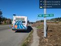
I signaled for a stop at Fuson Rd, then walked up its shoulder near intermittent traffic. Easy enough to locate the point, though couldn't stand on it for long.
Next I found the forest entrance and tried to follow WTA's suggested counterclockwise route through the maze of trails. The south end of the forest seemed empty of people, but I crossed paths with a deer on the aptly named Spotted Doe Trail. As I turned back north, I started triangular shapes scratched into the trail surface, and decided not to trust these for navigation. In the center of the forest I started encountering other hikers and heard a barred owl calling.
Since the bus simply runs every 30 minutes and isn't aligned with the ferry schedule, I had to choose between a return back to the ferry terminal at 15:40 or 16:10. If the ferry had been running behind schedule this would have been an easy decision, but I checked its location and it was still nearly on time. I considered how my outbound bus had had plenty of time for a layover and hadn't encountered traffic. Ultimately decided to spend another 30 minutes in the forest, rather than run for a bus and spend 30 minutes near the ferry terminal.
So I started watching the time as I ventured into the north end of the forest, crossing a small creek and stepping out of the way of a mountain biker. Just before I would have had to turn around, I realized there was in fact a bus stop at McWilliams Rd I could head for instead. And so I did, arriving 13 minutes before the bus to wait anxiously.
- Going to have a tight connection to the return ferry -- Coyotebush (talk) @47.6209,-122.6291 15:38, 17 March 2024 (PDT)
Return bus appeared precisely on time, then took a 5-minute layover back at the transfer center to avoid getting ahead of schedule. It arrived at the ferry terminal at 16:08 as ferry boarding had just started.
- Luckily the bus schedule is generous - caught up to the boarding line just as it reached the boat -- Coyotebush (talk) @47.5612,-122.6235 16:13, 17 March 2024 (PDT)
By this point I wanted ice cream, but no time on land and none stocked on board. I settled for juice. Same views in different light during the return crossing, and more progress on the book. Reversed the walk to the light rail station and rode that escalator down again. Acquired ice cream once home.
Tracklog
From point to bus:
Photos
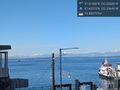
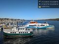
Ferries approaching @47.6037,-122.3365
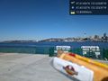
Ferrywurst? @47.6018,-122.3533
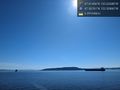
Blake Island, home to yesterday's hash @47.5676,-122.5086
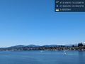
Almost to Bremerton @47.5683,-122.5962
Bus laying over at the ferry terminal @47.5629,-122.6248
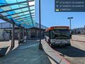
Goodbye bus @47.6142,-122.6287
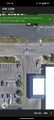
Hello Lowe's @47.6142,-122.6283
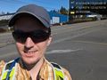
Hasher (point behind, near end of yellow line) @47.6140,-122.6270
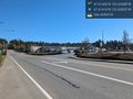
Middle of the road screenshot
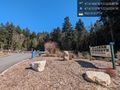
Hike time @47.6132,-122.6233

Oh deer @47.6081,-122.6203
Foot ferry active, fast ferries resting @47.5613,-122.6236
Almost back to Seattle @47.6024,-122.3962


Achievements
coyotebush earned the Public transport geohash achievement
|