Difference between revisions of "Albury Wodonga, Australia"
imported>Kieran |
m (per Renaming Proposal) |
||
| (104 intermediate revisions by 17 users not shown) | |||
| Line 1: | Line 1: | ||
| − | + | {{Announce|'''Geohashing''' is a fun way to explore different places in the area we live in, that we would not otherwise see. Every day a random set of GPS co-ordinates is generated, and your goal is to go there. For more information see the [[Main Page]].|bg=blue}} | |
| − | |||
| − | |||
| − | |||
| − | |||
| − | . | ||
| − | |||
| − | |||
| − | |||
| − | |||
| − | |||
| − | |||
| − | |||
| − | |||
| − | |||
| − | |||
| − | |||
| − | |||
| − | |||
| − | |||
| − | |||
| − | |||
| − | |||
| − | |||
| − | |||
| − | |||
| − | |||
| − | + | '''Albury Wodonga''' (graticule -36, 146) is officially two towns, located side by side on the New South Wales (Albury) / Victoria (Wodonga) border. Albury Wodonga is in the far north east corner of the graticule, geohashers in Albury Wodonga might also consider attending locations in the [[Corryong, Australia|Corryong]] graticule (-36, 147), the [[Corowa, Australia|Corowa]] graticule (-35, 146), or the [[Wagga Wagga, Australia|Wagga Wagga]] graticule (-35, 147). | |
| − | + | {{graticule | |
| + | |lat = -36 | ||
| + | |lon = 146 | ||
| + | |nw = [[Cobram, Australia|Cobram]] | ||
| + | |n = [[Corowa, Australia|Corowa]] | ||
| + | |ne = [[Wagga Wagga, Australia|Wagga Wagga]] | ||
| + | |w = [[Shepparton, Australia|Shepparton]] | ||
| + | |name = [[Albury Wodonga, Australia|Albury Wodonga]] | ||
| + | |e = [[Corryong, Australia|Corryong]] | ||
| + | |sw = [[Melbourne East, Australia|Melbourne East]] | ||
| + | |s = [[Mansfield, Australia|Mansfield]] | ||
| + | |se = [[Bairnsdale, Australia|Bairnsdale]] | ||
| + | }} | ||
| − | + | The Albury Wodonga region has a combined population of about 101,000. Albury City is the slightly larger of the two with 46,000 people, Wodonga has about 30,500 inhabitants. | |
| − | The | + | The other major city in this graticule is '''Wangaratta'''. Wangaratta is home to just over 15,500 people. |
| − | + | Features of the graticule include the Murray river, and part of Lake Mulwala, which offers a slight chance of a water geohash. The wine growing areas of Oxley and Rutherglen are dotted with vinyards and cottage wineries, touring the local wines is a popular tourist activity. Nearby Wangaratta is a well know Cathedral City. | |
| − | The | + | The graticule includes the Chiltern Mt Pilot National Park, the Mt Buffalo National Park, the Mt Samaria State Park and parts of the Wabonga State Park. The mountainous areas to the South East of the graticule offer plenty of opportunities for making us [[MNB_Geohash|Mother Natures Bitches]]. |
| + | == Upcoming Locations == | ||
| − | == | + | === Albury Wodonga === |
<table class="infobox" cellspacing="5" style="width: 22em; text-align: center; font-size: 88%; line-height: 1.5em; border: 1px solid #dd0; background-color: #ffc; color: black; margin: 0.5em 0 0.5em 1em; padding: 0.2em; left; clear: left; width:342px"> | <table class="infobox" cellspacing="5" style="width: 22em; text-align: center; font-size: 88%; line-height: 1.5em; border: 1px solid #dd0; background-color: #ffc; color: black; margin: 0.5em 0 0.5em 1em; padding: 0.2em; left; clear: left; width:342px"> | ||
| Line 46: | Line 33: | ||
Coordinate and map links -36, 146 | Coordinate and map links -36, 146 | ||
</th></tr> | </th></tr> | ||
| − | <!-- this | + | <!-- this tests the next four days and gives output. (on friday DJIA holidays, we can have up to 4 days known in advance!) In theory the whole TR sections should be inside the test... but I can't be bothered changing it right now. :) |
| − | + | ...also, if you change this, make sure ALL #time references are in sync per row! | |
| − | ... | ||
| − | ... | ||
| − | |||
--Nemo | --Nemo | ||
| + | ps. My thoughts are that this is for only what it links to here. Thus I don't auto-create links to empty wiki pages. IMHO, those should be created manually further down the page in the upcoming locations section. hand-tuned descriptions of the hashpoints also go there. | ||
--> | --> | ||
| − | <tr> | + | {{#ifeq: {{coords are announced|{{ #time: Y-m-d | +4 days }}|30w=1}}|1 |
| − | <td>{{ #time: l Y-m-d | +4 days }}</td><td> | + | |<tr><td>{{ #time: l Y-m-d | +4 days }}</td><td>{{egl|{{ #time: Y-m-d | +4 days }}|-36,146|text={{coordinates graticule|{{ #time: Y-m-d | +4 days }}|lat=-36|lon=146}}}}| }} |
| − | + | ||
| − | <tr> | + | {{#ifeq: {{coords are announced|{{ #time: Y-m-d | +3 days }}|30w=1}}|1 |
| − | <td>{{ #time: l Y-m-d | +3 days }}</td><td> | + | |<tr><td>{{ #time: l Y-m-d | +3 days }}</td> |
| − | + | <td> {{egl|{{ #time: Y-m-d | +3 days }}|-36,146|text={{coordinates graticule|{{ #time: Y-m-d | +3 days }}|lat=-36|lon=146}}}}| }} | |
| − | + | ||
| − | <tr> | + | {{#ifeq: {{coords are announced|{{ #time: Y-m-d | +2 days }}|30w=1}}|1 |
| − | <td>{{ #time: l Y-m-d | +2 days }}</td><td> | + | |<tr><td>{{ #time: l Y-m-d | +2 days }}</td> |
| − | + | <td> {{egl|{{ #time: Y-m-d | +2 days }}|-36,146|text={{coordinates graticule|{{ #time: Y-m-d | +2 days }}|lat=-36|lon=146}}}}| }} | |
| − | <tr> | + | |
| − | <td>{{ #time: l Y-m-d | +1 | + | {{#ifeq: {{coords are announced|{{ #time: Y-m-d | +1 days }}|30w=1}}|1 |
| − | + | |<tr><td>{{ #time: l Y-m-d | +1 days }}</td> | |
| − | <td>{{ #time: l Y-m-d }}</td><td> | + | <td> {{egl|{{ #time: Y-m-d | +1 days }}|-36,146|text={{coordinates graticule|{{ #time: Y-m-d | +1 days }}|lat=-36|lon=146}}}}| }} |
| − | + | ||
| + | {{#ifeq: {{coords are announced|{{ #time: Y-m-d }}|30w=1}}|1 | ||
| + | |<tr><td>{{ #time: l Y-m-d }}</td> | ||
| + | <td> {{egl|{{ #time: Y-m-d }}|-36,146|text={{coordinates graticule|{{ #time: Y-m-d }}|lat=-36|lon=146}}}}| }} | ||
| + | |||
</table> | </table> | ||
| + | === Nearby Graticules === | ||
| + | |||
| + | Co-ordinates for the "Tallangatta / Mt Beauty" graticule can now be found on the [[Corryong, Australia|Corryong]] page. | ||
| + | |||
| + | == Planning Pages == | ||
| + | |||
| + | Add details of any expeditions you plan on mounting here. | ||
| + | |||
| + | == Meetups == | ||
| + | |||
| + | Show up to the geohash co-ordinates at 4pm on any given Saturday, you never know who might be there. | ||
| + | |||
| + | Actually, the odds of that happening are pretty low around here, but if you do happen to attempt a hash in -36 146, send Kieran a message on 0430509913 and he might join you. | ||
| + | |||
| + | == Past Expeditions == | ||
| + | *[[2022-04-15 -36 146]] - Deep in a paddock during a ride up Hotham. | ||
| + | *[[2021-04-06 -36 146]] - In bushland near Beechworth. | ||
| + | *[[2020-11-18 -36 146]] - In a fallow field east of Benalla at dusk. | ||
| + | *[[2020-10-20 -36 146]] - In a cow field east of Benalla late at night. | ||
| + | *[[2020-09-20 -36 146]] - Failed attempt near Beechworth. | ||
| + | *[[2020-09-18 -36 146]] - In a field near Benalla. | ||
| + | *[[2020-08-21 -36 146]] - Just outside Benalla, riding home from work. | ||
| + | *[[2015-12-31 -36 146]] - Success! Next to the Ovens River near Wangaratta, on a cycle tour. | ||
| + | *[[2012-06-01 -36 146]] - Livestock Fail :( | ||
| + | *[[2010-05-21 -36 146]] - success! | ||
| + | *[[2010-05-17 -36 146]] - Near miss ... although I thought I'd done it at the time! | ||
| + | *[[2009-09-07 -36 146]] - success | ||
| + | *[[2009-08-30 -36 146]] - Near miss... | ||
| + | *[[2009-07-24 -36 146]] - Success | ||
| + | *[[2009-07-17 -36 146]] - Fail | ||
| + | *[[2009-01-01 -36 146]] - failed! | ||
| + | *[[2008-12-23 -36 146|2008-12-23 -36, 146]] - success! | ||
| + | *[[2008-09-29 -36 146|2008-09-29 -36, 146]] - success! | ||
== Geohashers == | == Geohashers == | ||
| − | [[User:Kieran|Kieran]] - When I'm not in [[Canberra, Australia|Canberra]]. | + | Add your name here if you want to get in touch with other geohashers in the Albury Wodonga area. |
| + | |||
| + | * Acajou - doesn't have a login, but joins us from time to time. | ||
| + | * Fi - get's dragged along by Kieran from time to time. | ||
| + | * [[User:Kieran|Kieran]] - When I'm not in [[Canberra, Australia|Canberra]]. Contact me on 0430509913 | ||
| + | |||
| + | |||
| + | '''JOIN THE FACEBOOK GROUP!''' | ||
| + | http://www.facebook.com/group.php?gid=59113165329 | ||
| + | |||
| + | == Gallery == | ||
| + | |||
| + | A selection of photos from past meetups in our area. | ||
| + | |||
| + | <gallery> | ||
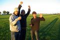
| + | Image:Kieran.jpg| [[user:Kieran|Kieran]] at [[2008-09-29 -36 146|2008-09-29 -36, 146]] | ||
| + | Image:Acajou2.jpg| Acajou walking back to the car from [[2008-09-29 -36 146|2008-09-29 -36, 146]] | ||
| + | Image:-36-146-firstdam-coords.jpg|[[2008-12-23 -36 146|2008-12-23 -36, 146]] | ||
| + | Image:-36-146-road2.jpg|[[2008-12-23 -36 146|2008-12-23 -36, 146]] | ||
| + | Image:2echidna-1-1-09 -36-146.jpg|An echidna near [[2009-01-01 -36 146]] | ||
| + | Image:1footings 2009-01-02 -36-146.jpg|Footings of an old building on the floor of lake hume, near [[2009-01-02 -36 147]] | ||
| + | Image:6trees 2009-01-02 -36-146.jpg|Trees, with the soil washed away from the roots, near [[2009-01-02 -36 147]] | ||
| + | Image:MitchAdamFelix20090724s36e146.JPG|Mitch, Adam and [[User:Felix Dance|Felix]] at [[2009-07-24 -36 146]] | ||
| + | </gallery> | ||
| + | |||
| + | == Achievements == | ||
| + | {{Graticule unlocked | latitude = -36 | longitude = 146 | date = 2008-09-29 | name = [[user:Kieran|Kieran]] and Acajou}} | ||
| − | [[Category: | + | [[Category:Victoria]] |
| − | [[Category: | + | [[Category:New South Wales]] |
| + | [[Category:Inactive graticules]] | ||
| + | [[Category:Unlocked graticules]] | ||
| + | [[Category:Meetup in -36 146]] | ||
Latest revision as of 04:35, 20 March 2024
Albury Wodonga (graticule -36, 146) is officially two towns, located side by side on the New South Wales (Albury) / Victoria (Wodonga) border. Albury Wodonga is in the far north east corner of the graticule, geohashers in Albury Wodonga might also consider attending locations in the Corryong graticule (-36, 147), the Corowa graticule (-35, 146), or the Wagga Wagga graticule (-35, 147).
| Cobram | Corowa | Wagga Wagga |
| Shepparton | Albury Wodonga | Corryong |
| Melbourne East | Mansfield | Bairnsdale |
|
Today's location: geohashing.info google osm bing/os kml crox | ||
The Albury Wodonga region has a combined population of about 101,000. Albury City is the slightly larger of the two with 46,000 people, Wodonga has about 30,500 inhabitants.
The other major city in this graticule is Wangaratta. Wangaratta is home to just over 15,500 people.
Features of the graticule include the Murray river, and part of Lake Mulwala, which offers a slight chance of a water geohash. The wine growing areas of Oxley and Rutherglen are dotted with vinyards and cottage wineries, touring the local wines is a popular tourist activity. Nearby Wangaratta is a well know Cathedral City.
The graticule includes the Chiltern Mt Pilot National Park, the Mt Buffalo National Park, the Mt Samaria State Park and parts of the Wabonga State Park. The mountainous areas to the South East of the graticule offer plenty of opportunities for making us Mother Natures Bitches.
Contents
Upcoming Locations
Albury Wodonga
|
Coordinate and map links -36, 146 | |
|---|---|
| Monday 2024-05-20 | -36.6193744, 146.2604976 |
| Sunday 2024-05-19 | -36.5388936, 146.0974074 |
| Saturday 2024-05-18 | -36.1728929, 146.0998813 |
Nearby Graticules
Co-ordinates for the "Tallangatta / Mt Beauty" graticule can now be found on the Corryong page.
Planning Pages
Add details of any expeditions you plan on mounting here.
Meetups
Show up to the geohash co-ordinates at 4pm on any given Saturday, you never know who might be there.
Actually, the odds of that happening are pretty low around here, but if you do happen to attempt a hash in -36 146, send Kieran a message on 0430509913 and he might join you.
Past Expeditions
- 2022-04-15 -36 146 - Deep in a paddock during a ride up Hotham.
- 2021-04-06 -36 146 - In bushland near Beechworth.
- 2020-11-18 -36 146 - In a fallow field east of Benalla at dusk.
- 2020-10-20 -36 146 - In a cow field east of Benalla late at night.
- 2020-09-20 -36 146 - Failed attempt near Beechworth.
- 2020-09-18 -36 146 - In a field near Benalla.
- 2020-08-21 -36 146 - Just outside Benalla, riding home from work.
- 2015-12-31 -36 146 - Success! Next to the Ovens River near Wangaratta, on a cycle tour.
- 2012-06-01 -36 146 - Livestock Fail :(
- 2010-05-21 -36 146 - success!
- 2010-05-17 -36 146 - Near miss ... although I thought I'd done it at the time!
- 2009-09-07 -36 146 - success
- 2009-08-30 -36 146 - Near miss...
- 2009-07-24 -36 146 - Success
- 2009-07-17 -36 146 - Fail
- 2009-01-01 -36 146 - failed!
- 2008-12-23 -36, 146 - success!
- 2008-09-29 -36, 146 - success!
Geohashers
Add your name here if you want to get in touch with other geohashers in the Albury Wodonga area.
- Acajou - doesn't have a login, but joins us from time to time.
- Fi - get's dragged along by Kieran from time to time.
- Kieran - When I'm not in Canberra. Contact me on 0430509913
JOIN THE FACEBOOK GROUP!
http://www.facebook.com/group.php?gid=59113165329
Gallery
A selection of photos from past meetups in our area.
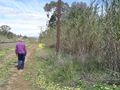
Acajou walking back to the car from 2008-09-29 -36, 146
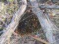
An echidna near 2009-01-01 -36 146
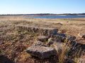
Footings of an old building on the floor of lake hume, near 2009-01-02 -36 147
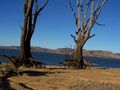
Trees, with the soil washed away from the roots, near 2009-01-02 -36 147
Mitch, Adam and Felix at 2009-07-24 -36 146


Achievements
Kieran and Acajou earned the Graticule Unlocked Achievement
|