2009-05-08 49 -120
| Fri 8 May 2009 in 49,-120: 49.3822991, -120.1317194 geohashing.info google osm bing/os kml crox |
Contents
[hide]Location
Up a hill, across Highway 3 (Crowsnest), 1.3 km from Stemwinder Provincial Park campsite, east of Princeton.
Participants
Planning
Robyn and Rhonda have been meeting each other at or on the way to geohashes ever since Rhonda joined the sport, and Vancouver is such an active graticule that the two have each met a number of geohashers. Meanwhile Juventas has been geohashing since July 2008 but due to the sparse population and remote locations in his graticule, has never met another geohasher. He posts spectacular photographs of rugged scenery, and eye-opening accounts of his attempts to reach remote locations, so clearly he was up for a challenge. In the interest of geohasher camaraderie and increasing connectivity on the Meetup Graph it was time for a road trip.
We started planning this trip a few weeks ago. We decided that it would involve overnight camping, ideally to earn the at-that-time-unclaimed Camping geohash achievement. While we were still negotiating a mutually free weekend, an ideal camping geohash came up in Bellingham and Robyn and Rhonda went and did it, but Juventas still needed the achievement for his portfolio, plus Robyn and Rhonda needed more practice camping. We settled on May 9th/10th, but it's very difficult to make detailed advance plans for a geohash, as we wouldn't know where it was until the weekend arrived. Juventas lives 450 km away from Robyn and Rhonda, with six different graticules on the road in between, so we decided that when the weekend coordinates came out on Friday morning we would discuss them and choose the best one(s) in between in which to meet. There were no known geohashers in the intervening graticules.
Coordinates are announced on Friday at 6:30 a.m. Pacific time, so we woke then and started searching for points that were accessible and possibly appropriate for camping. Juventas had maps and local knowledge of the graticules closer to him, so Robyn and Rhonda concentrated on the graticules closer to them. Princeton looked achievable on the Friday, and Juventas said that Kelowna was doable, so Robyn and Rhonda decided to go to Princeton on the way to the Kelowna area. Then Juventas, who had taken Friday off, said he would meet the women there. We arranged a rendezvous at Stemwinder Provincial Park, and started the road trip.
Expedition
Robyn
My purist vision of geohashing would have us specify no other meeting place than the geohash itself. I have this sustained image of people from different places climbing up different faces of the same mountain and slowly converging on the same otherwise undistinguished point. But romantic notions take second place to safety, and it's a much better idea to meet at the base of the mountain and all climb it together. That way no one gets eaten by a bear, or falls down and is never found again, except maybe by a bear.
I packed the car with a small inflatable boat, some rope, a lifejacket, a tent, two sleeping bags, a couple of knapsacks of different sizes, a stove, fuel, a warm jacket, raingear, a couple of changes of clothes, GPS, compass, chalk, and a Twister game. I added my trusty hashscot T-Rex to the pile and drove to North Vancouver to pick up Rhonda.
Rhonda
After finding out that the Friday and Saturday co-ordinates for all the graticules and days we were interested in were relatively close to highways (or at least logging roads), I packed my usual camping gear, ran around in circles trying to find everything that I had forgotten to pack on the previous camping trip, included all remaining apples and bananas from my counter in my packing, and carried it all out the front door to wait for Robyn.
The drive
Rhonda was at the curb and her backpack fit into the car with T-Rex and Robyn's gear, so they were soon underway together. Friday morning traffic was light and there were no delays getting onto the Trans-Canada highway or out of the city. Rhonda texted Juventas with an eta of about 1:30 p.m. Robyn's little car hummed along over the Port Mann Bridge and past sites of earlier geohashes, reaching them disorientingly quickly compared to our usual bicycle or transit transportation. Within an hour we were beyond our previous most distant geohash and the mountains began to close in on the highway.
After the town of Hope the Trans-Canada highway heads north to Lytton and Cache Creek before turning east to fulfill its name; we didn't want that, nor could we take the newer six-lane Coquihalla Highway at 110 km/h straight to the interior. To get to Princeton we had to take the exit leading to the old Crowsnest highway. It has a reputation as a treacherous road, because it clings to the cliff on the north with a sheer drop to the Similkameen River on the south, winding its way through the mountains. There is almost no room for a shoulder in most places, and there have been a number of bad accidents here over the years. But the highway has had some improvements, and on a clear day like this one with light traffic it was a fun drive. We went south through Manning Park (and took a break there at a rest stop with an outhouse) then turned north and exited the park through Alison Pass. We drove past Copper Mountain (where everything is named after the mountain), through Princeton (which the graticule is named after), and found Stemwinder Provincial Park.
It's a little gem of a park tucked into a widening of the space between the highway and the fast-flowing Similkameen River. The best campsites are on the lower road, closer to the river and further from the highway. There was almost no one in the campground, so we parked in campsite #1, closest to the road, and sorted out which gear we to take to the geohash, while we waited for Juventas. The Similkameen looked like it would be fun to kayak on... downstream. It was fast, but there wasn't much in the way of white water, at least in the parts visible from Stemwinder park.
There was only intermittent cell service on the highway between Hope and Princeton so texts from Juventas and Rhonda's replies had been slow. One message had said he'd be at Stemwinder at two. Another one amended that, saying he was stuck in construction. Rhonda and Robyn didn't know if he was getting any of their messages, because cellphones just don't work in BC outside the cities. There are too many mountains. With no cellular service at the campsite, they had no way of knowing how far away Juventas was.
At 3:30 p.m. Rhonda and Robyn realized that if anyone is going to reach that geohash, they had better start soon, so they chalked a message to Juventas on the pavement, and set off on foot towards the geohash.
Juventas
Waiting for his story and photos.
Hiking up
Just as Rhonda and Robyn were crossing the highway, a car matching the one Juventas geohashes with pulled into the campground. The next phase of the expedition could begin.
We left the cars in the campground, 1.3 km from the geohash, and crossed the highway to get to a road that led partway towards the geohash. There was no gate on the road, just a cattleguard: an open pit covered by round metal bars spaced far enough apart for a cow's hoof to fall through. Cars can drive over it, deer can easily leap over it, and people can walk over if they are careful, but cows won't try to balance on the pipes, because that would be tricky with hooves, and they have a natural fear of falling into pits. Juventas was curious as to why Rhonda and Robyn chose to walk, not drive on the road, but accepted the answer that Robyn didn't start her car for trivial distances. Also Robyn's car is a street vehicle, not accustomed to dirt roads through rangeland. Neither is Robyn.
The road was leading off to the right of the geohash, but soon made a sharp switchback and started back to the left of the direct course, but still getting closer to the point. We enjoyed looking down from the road to see how quickly we were gaining altitude above the river. We were walking past rocks and trees, mostly, but about six hundred metres past the cattleguard the road approached a small meadow, oddly level and with green grass growing on it. The grass was very short. It looked like an idyllic campsite, and we could even drive in. It was within 750 metres of the geohash, so assuming we made the point, it would give us the camping achievement. That discussion was interrupted when a number of deer, no doubt those responsible for the short grass, ran across the road and bounded up the slope into the trees. We considered going up the deer trail, as it did point pretty much towards the geohash, but decided to continue on the road a little longer, as we were still getting closer to the geohash.
The road brought us to within 700 metres of the geohash, but then continued on and didn't appear to have any more switchbacks, so we left the road there and headed up a slope that was covered in trees and small bushes. Soon it became steeper, and covered with rocks. It was steep enough that we needed to use hands as well as feet from time to time. Every time the terrain changed slightly, the GPS needles pointed up the steepest part. It didn't look as if the hill went another 500 metres on from where we were, so we wondered if maybe we would go up this hill and down the other side. That wasn't the way we remembered it from the Google Maps topographic view, though, and that wasn't the way it was. We reached a slight plateau and from there we could see that after crossing a gully, we had enough hill left to climb. We would be going pretty near the peak, from the looks of it.
Then we met a cliff. A direct line to the geohash led straight up it, but it was too steep to be casually climbed. Juventas explored to the right and soon reported "well we're not going this way," so we tried going around it to the left. There was a bit of scrambling and a "don't come this way" recommendation that was slightly too late, but it's easier to continue than go down, so we all got on top of the cliff where there was easier going. Also a few spots of rain. We had passed a few burned trees, probably from lighting strikes, so we scanned the sky but saw no thunderstorm brewing. The rain soon stopped. We were now halfway from where we left the road to the geohash.
We intersected a grassy trail, and followed it up for a couple of switchbacks until we were "double digits" metres from the geohash. GPS reception was good and we easily found the point on a slope. A slope with rocks and trees.
Success

We stopped and celebrated our success with a quick game of Twister. We cheated a bit, refusing spins that made our positions too dangerous, but if you look at the inconvenient positioning of the game board, you have to agree we needed some rule modification. We came up with an idea for an alternate form of Twister more suited to the kind of terrain we get at geohashes. Perhaps we'll have a chance to show it to you at a future geohash.
Rhonda marked the coordinates with some sticks and then we headed down.
Hiking down
We decided to go straight down, instead of back to the trail, warning each other to be careful we didn't walk over a cliff. We talked about the possibility of writing a guide to geohashing safety, augmenting the "don't do anything dangerous" disclaimer in the official warning, but every area is different. A German geohasher doesn't have to be warned not to put his hands on top of rocks he can't see, because there are no rattlesnakes in Germany. A British geohasher doesn't need to carry as much water as an Australian one. We didn't walk over any cliffs or rattlesnakes, and only one of us ran out of water. With the assistance of gravity, we soon came out at the road, right where the deer had come up. We should have taken that deer trail. But then we wouldn't have had the fun of a different way home.
The deer were back, but all fled at our approach. They were very cagey, with a longer than usual flight distance for deer seeing people on foot. There must be a lot of people hunting around here. Even though our shadows were lengthening, we decided not to camp in the deer meadow, but instead continue to a Forest Service campsite near a geohash in another graticule.
Photos
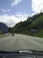
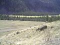
Starting our trip on highway 1 (trans-canada)
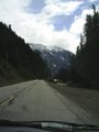
Continuing along highway 3 (crowsnest)
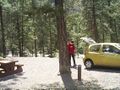
The closest legal parking spot...
Not waiting any longer
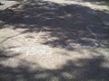
The first part was easy
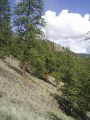
the next part a little less so
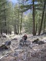
Rhonda walking up the slope to the geohash
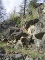
Sometimes it wasn't really a slope
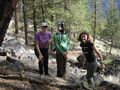
Robyn, Juventas and Rhonda at the geohash
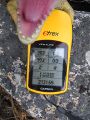
T-Rex shows proof of our arrival
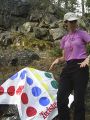
Twister, anyone?
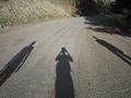
Our shadows precede us down the access road


Robyn, Rhonda & Juventas earned the Graticule Unlocked Achievement
|