2010-07-01 49 -123
It's Canada Day and Vancouver has an accessible geohash!
| Thu 1 Jul 2010 in 49,-123: 49.2381376, -123.1819624 geohashing.info google osm bing/os kml crox |
Location
Collingwood, at the alley between 37th & 38th.
Participants
Plans
I was going to summarize the back-and-forth below and move it all to the discussion page, but it is a simple and complete description of what passes for planning in the Vancouver graticule. Such a trivial geohash on such an auspicious day, what else could we do?
I intend to paint maple leaves on my face, go to the geohash around noonish, and decamp to a picnic area. Does anyone know of a nearby park with somewhat weather-resistant picnic facilities? None of Malkin, Memorial and Balaclava appears to have picnic tables, but Malkin looks the most picnic-friendly. I have tarps. -Robyn 16:19, 1 July 2010 (UTC)
- [comments redacted --- I have been informed that 40 blocks (up and over a rather tall hill) does not meet any reasonable definition "near". And, oddly enough, we are going against Geohashing tradition by using a reasonable definition of "near".] --Wade 17:06, 1 July 2010 (UTC)
I'm thinking of biking it. I have lots of transit-bike hashes, but the only one I biked to 100% was a no trespassing hash. It takes me 30 minutes to get downtown, and about 1:15 to get to UBC, so it should only be an hour's ride or so. I doubt more than an hour and a half. -- Rhonda 16:35, 1 July 2010 (UTC)
I'm biking it too. It's right on the bike route by our house. Also, it's Canada Day. Any bookable picnic will be booked. -Robyn 16:57, 1 July 2010 (UTC)
Ok. I'm planning on leaving home at 11, so I should be there 12:15 or 12:30, roughly. -- Rhonda 17:43, 1 July 2010 (UTC)
It's a Canada miracle! See you all at Collingwood and 37.5st at noon! -- [[user:thepiguy]] 16:58, 1 July 2010 (UTC)
I have plans for the day, but I hopefully should be there later in the afternoon. - Elbie 17:39, 1 July 2010 (UTC) My plans should end around 1ish, so, being bikeless and UPassless, I'll do this one as a walkhash. I'll probably be there at 2 unless I postpone the walk to coordinate some company for the trek. - Elbie 18:18, 1 July 2010 (UTC)
Aiming to be there around 13:00 to 13:30. -Srs0 18:44, 1 July 2010 (UTC)
Expedition
Rhonda
I planned to leave home at 11:00 to be there shortly after noon, and managed to get out the door only 5 minutes later than planned. About the first half of the trip was my normal commuting route on the 1st St. bike route past the old BC Rail station, through the Squamish Nation reserve, under then over the Lions Gate Bridge, and through Stanley Park, up to the point where the road leaves Stanley Park and goes into downtown Vancouver.
At that point, I turned south and went along a bike route (Chilco) that had a few segments blocked off to cars despite once having been a road through, then along the Seaside bike route that follows the seawall and beaches of English Bay, over the Burrard Bridge on the ex-car lane new blocked off and dedicated to cyclists, along another bike route named "Seaside" on the other side of the bay (it does actually go all the way in and around so it's the same bike route, but the bridge is a shortcut), then up a bike route named "Balaclava" which was mostly but not entirely on Balaclava St., and which brought me to a park at 29th and Balaclava where there was a water fountain beside an empty wading pool. I was very thirsty at this point, having been riding for about an hour and having also forgotten my water bottle, so I was happy to see that the water fountain worked. My commute is a ~10km half hour ride, and even in the heat of summer I don't need water during that short of a time so I have lost the habit of bringing water with me.
Just past the water fountain, the road turned west, and neither it nor the dirt trail leading south through the park and past a group of people playing something on the field were marked as a bike route, so I followed the road. The next left was an alley, but the road past the alley went uphill. I knew there was a hill between the north and south parts of this particular peninsula, having lived here in the past, but I was hoping to skirt around it instead of going over the highest point since I knew the land also rose up to the point that was UBC to the west. So, I went into the alley. It also went uphill, but not as steeply and I don't think as high. I briefly considered going back to Balaclava street, but then decided to stay in the alley as Balaclava was east, and the hashpoint was still a block and a half west of me. At 35th, the alley turned to dirt so I headed west for a block and a half, and coasted the last two blocks down to the hashpoint, where five people had already set up a picnic.
Excepting the first few blocks from my house to the beginning of the 1st St. bike route, and the last few blocks where I lost the bike route and went down an alley, the entire 19km ride was on marked and signposted bike routes.
Finally, I have a bicycle hash - not a transit/bike hash, or a car/bike hash, or a bike/no trespassing non-achieved hash.
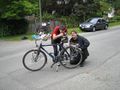
Wade and Robyn
We planned to leave at 11:30 to be there at noon. Around quarter to eleven, Robyn went off to purchase picnic supplies, and Wade added an appropriate amount of air to the bicycle tires, and packed (most of) the stuff we'd need. Eventually Robyn returned, and started with the "did you pack the ...?" questions, which prompted mostly "Yes", and the occasional "not yet" reply. We messed about for a few minutes packing all the stuff Wade forgot to pack while there was lots of time, then left at around 11:40.
It's a nice simple ride along the Ridgeway bicycle route from home to the geohash. We met a nice couple cycling along our route, one of whom scolded Robyn for not riding in a perfectly straight line, and then blew through a stop sign without so much as slowing down. Gotta love considerate cycling rules!
We turned left from 37th to Ridgeway, and immediately noticed thepiguy on the side of the road, on the NW corner of the intersection of 37.5 Ave and Collingwood. As we pulled over to join him, we noticed Xore and Rhonda's Hashmobile parked on the SW corner of the same intersection. Xore, tpg and Wade were just getting through their "Hello"s when we saw a car with Washington plates arrive.
thepiguy
He biked. He got there first. He might write about his adventures here.
Xore
He drove. He arrived later than he expected, but still in the first wave.
srs0 and air384
They took transit. With squishies from 3.2 km away. Better update coming soon!
Update from 8 months later:
Unfortunately, I don't remember too much anymore. However, here's the proof of geosquishies and transit!

Squishies located.

The bus stop by the squishy store.

Riding the bus.

At the hashpoint.


Almost Everyone
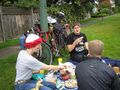
Picnic
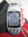
Because it was a bit sunnier on the NW corner, we set up our picnic there, in clear sight of the hashpoint, which was on the SE corner. We spread out two picnic blankets and a jacket and everyone seemed reasonably comfortable. It only rained a little bit. Every once in a while someone would wander over from the picnic area to the hashpoint to mark it with chalk or photograph their GPS or otherwise indicate they made it.
We took pictures, which hopefully will be put up soon.
We ate seven layer dip, hummus, pita, carrots, oranges, red tortilla chips, and cheese, alfalfa sprout and vegetarian 'salami' sandwiches. We had nice raspberry flavoured beverage. We ate some black forest cake, which we cut into six pieces and consumed moments before the seventh and eighth geohashers turned up. Vancouver is a graticule with the magnificent 'problem' of having too many geohashers to satisfy with only one cake.
We discussed how much fun it was to have a spontaneous picnic, and looked forward to meeting Joannac this weekend.
Other Activities
Rhonda juggled both beanbags and rings. She was better at the beanbags.
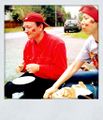
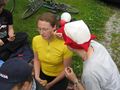
Robyn painted maple leaves on people's faces. Or more accurately, Robyn offered to paint maple leaves, Canadian flags, or stars (for the non-Canadian) on everyone's faces, and all but Rhonda hastily procured or displayed existing red or maple-leaf themed garments, which they believed exempted them from face-painting. Wade and thepiguy decided, after an etymological discussion of the word "facepaint" that it was acceptable for Robyn to use lipstick and eyeliner as face paint after she was halfway through painting a maple leaf on Rhonda's face with them.
A woman from across the road came over wielding a rake. She had no objection whatsover to our picnicking at her intersection. She had captured on the tines of the rake the largest slug she had ever seen and wished to display it for us. It really wasn't that large, as Vancouver slugs go, but it was the largest she had ever seen so we agreed that it was large and slimy, and photographed it. After that no one wanted any more bean dip, but as the slug-wielding lady was accompanied by a medium-sized dog, we then engaged in what we believe was the largest mass geodog patting to date. The event was recorded photographically. The dog shed lots of hair during the encounter, but the wind was blowing away from the food. The woman took her slug back to show her husband and assured us that if we needed anything from her place we could ask.
Selected Quotes
"It would be a shame to have to log this as 'Coordinates Not Reached -- Forgot to Cross Street'." -- Wade, comfortable on a picnic blanket across the street from the actual hashpoint.
The geohash was right on Ridgeway, one of the main east-west bike routes in Vancouver. (You can ride a bicycle pretty much anywhere cars can go in the city, but bike routes have signage, bicycle-activated stop lights crossing major arteries, shortcuts cars can't take, reduced numbers of stop signs, and a commitment to maintaining the pavement to standards suitable for 100 psi tires). Thus there was a lot of bicycle traffic, and it's hard to miss a pile of picnickers right on the edge of the road, next to a pile of bicycles.
"A bicycle picnic!" exclaimed one of two young women riding up the hill. "Can we come?"
"Yes!" we all assured them. "Please! We mean it! Really!" But they rode on. I guess they didn't mean it.
A passing pedestrian was more succinct in her rejection of our company. Observing the hashcots being prepared for their group photo, she said only, "Weird," and continued without further interaction.
Most people waved, or called out "Happy Canada Day!"
Lots of other people said funny things. Perhaps someone will remember and reiterate.
Elbie's later expedition
Having plans that afternoon, I missed the group festivities -- I set out on foot around 3 with a friend, planning to walk the whole way. This, of course, did not go as planned. First, my GPS's batteries died. A detour was made to Save-On to get more.
Upon our arrival at the grocery store, distraction ensued. Free food for Canada Day! The two hungry university students were immediately ensnared.
Free cake consumed, batteries acquired, and sufficient time spent to make my friend worry about her later plans that day, half an hour later I found myself resuming the expedition alone. Some time after deciding to take the scenic route through the Pacific Spirit Regional Park, I discovered -- quite unluckily enough -- as I was entering TRIUMF dead zone that the paper upon which I'd written today's coordinates had gone missing.
About a kilometre away from the trailhead at 33th & Camosun, my cellphone decided it had found service again. Phoning srs0, I was informed the coordinates had been well chalked, and wouldn't need the exact coordinates. He was right! After walking up the hill to Collingwood and then wandering down to 37th, I pretty quickly noticed the pink chalk across the street.
Photos
People + picnic blankets + food = picnic

More picnic fun!
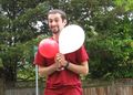
Next time thepiguy will not be in charge of balloons.
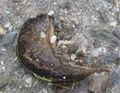
The largest slug the neighbour lady had ever seen.
Group shots for this graticule require special equipment.
The Pi Guy cannot blow up balloons.
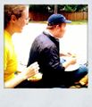
Picnic foods.
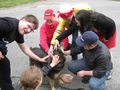
A poor unsuspecting hashdog is assaulted by the majority of the entire Vancouver graticule.
For some Canada day celebration.
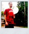
Facepainting!
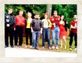
The group shot.
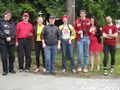
And again!
In case there was any doubt.


Achievements
- Geosquishy for Srs0 & Air
Most participants earned the doghash achievement
|
Most participants earned the Picnic achievement
|
Air and all other participants earned the Land geohash achievement
|
All participants earned the National Day Geohash
|
thepiguy, Wade, Robyn and Rhonda earned the Bicycle geohash achievement
|
Elbie earned the Walk geohash Achievement
|