Location
In the forest north of Bremerhagen (Sundhagen), VR, MV, Germany.
Participants
SastRe.O
Plans
I'll grab Winterbuche in about... 40 minutes? More or less. After that I expect about 3 hours to reach the hash. Once there, after the dance, I might go after some caches, and map the forest with my GPS since it seems that some of the paths that google maps suggest are not in OSM. --SastRe.O (talk) 07:01, 3 August 2019 (UTC)
Expedition
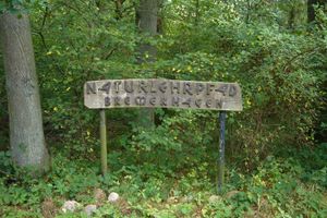
Naturlehrpfad Bremerhagen.
Well, not 40 but 60 after I posted my plans (meaning, at 10:06) I grabbed Winterbuche to go after today's Hash. The idea was clear. The first part, until Horst, would be very similar to the first expedition I had this 2019, this one, only that I did it rather faster than expected, mainly because this time I took the main road.
In Horst I rested a while, because I wanted to try to fix a go-pro I have to the bike and capture in video the rest of the expedition. I wanted to give it a try, and see what I got. Only to find out, once everything was in place, that it had no battery ¿^^ Yesterday seemed fine... When I get home I must see what happened. Well, no video for this expedition.
After Horst, I took some path between fields heading NW. Beautiful views from the harvested fields and the spinning wind turbines. Here I crossed the B96 over, through a bridge and stopped to search for today's first geocache. Easy one, and after that, very near, I stopped for a second geocache, near a pond, where some fishermen where in action. Peaceful corner, that must be said.
The I started to approach the forest by Bremerhagen, and as the location of this expedition suggest, today's goal. Once inside, the paths where quite clear, and after following the arrow on my GPS, which kept a steady countdown, I arrived at the hash, right on the left (on the east) of the path. Parked Winterbuche there, danced for a while trying to get the exact coordinates showing on my GPS and took photographic proof of the site.
While dancing with my GPS I heard a couple of thunders, somewhere far away in a NE direction. That I did not expect. Weather forecast for today said sunny and no probability of rain. My way home was SE. And the sky seemed fine, maybe some kind-of-darkish clouds in the NE. Well, it did not make my worry but I was expectant what would happen.
This forest area turned out to be quite interesting. There is this Lehrpfad (Educational trail) with very interesting dioramas and interactive panels, that explain about the life in the forest, its inhabitants, different kinds of trees you can find and so one. It was the way to expose it which made it kind of different to other Lehrpfade I've encountered.
Here I found two more geocaches, well placed and fun to find. And for the whole time I was there I saw no one. Not entirely true: I say some Woodpeckers and deer, which ran away startled. What I didn't meet were human beings. Well, once leaving the forest I encountered the first one which was parking his car.
I left the forest through the south side (I arrived north) and started the way back. Once in Horst again, ended the circular part and took almost the same path I took some hours before to reach home.
In Wackerow, very near already from Greifswald, I took a shortcut taking some residential streets with the great surprise I passed by an idyllic corner, by the village pond (or however Dorfteich is translated) with a very new little wood-bridge and a resting area. I took the chance, well, to rest for a few minutes. I drank the last drops of water I had with me. Remember that thunders I heard, I ended up being nothing. It kept sunny and warm, and the water was just enough to arrive home.
And that's it. Nice 57km and 5:30 hours in total.
Tracklog
Photos
| Winterbuche enjoying the view. |
| Hash is on this path. Just 100m ahead. |
| Reached! Here it shows 2m to hash. |
| Winterbuche parked right on the hash. |
| Exact hash coordinates :) |
| One example of the dioramas of this Lehrpfad. |
| Some houses are protected by dogs, others by aggressive sheep |
|
Achievements
Other Geohashing Expeditions and Plans on This Day
Expeditions and Plans
| 2019-08-03
|
| Muskegon, Michigan |
Mcbaneg |
side of Cline Road, Fruitport, MI
|
| Pendleton, Oregon |
Michael5000 |
In the woods south of LaGrande.
|
| Hermiston, Oregon |
Michael5000 |
In National Forest land, not far off the road from Ukiah to Heppner.
|
| Stralsund, Germany |
SastRe.O |
In the forest north of Bremerhagen (Sundhagen), VR, MV, Germany.
|
Update this list.


