2023-07-11 43 -79

| Tue 11 Jul 2023 in 43,-79: 43.6926980, -79.4607034 geohashing.info google osm bing/os kml crox |
Location
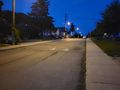
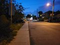
On McRoberts Avenue just south of Eglinton.
Participants
Expedition
Before embarking, I was down in The Annex for Puzzled Pint, a cute miniature puzzle hunt held monthly in a number of cities worldwide. I left around 9pm, aiming to dodge potential thunderstorms, and took Line 1 up to Eglinton West and then the bus to Caledonia Road. Not a difficult trip!
Just as with the last couple expeditions in the vicinity of Eglinton, I took the opportunity to check out the new transit stations. On this expedition, I saw Caledonia station, which is planned to eventually be an interchange with an electrified Barrie Line regional train station, and Fairbank station at Dufferin. The buildings strike me as a little overbuilt — Fairbank especially — but on the other hand they look quite nice and probably will help with wayfinding and placemaking. If I go to a subway station downtown that I'm not used to, I'll often have to wander around a little before I can find the entrance. This won't be a problem with the new Eglinton stations! These impressive monuments are visible from a few blocks away.
A common adage is that the journey is more important than the destination, and geohashing is a hobby which exemplifies this idea. This expedition was no exception: I spent maybe a minute at the hashpoint. It's important to note, though, that this saying leaves out the most important thing about traveling: collecting pointless stats about the trip.
Pointless stats, and a rant about Google Maps


A relatively recent addition to the geohashing achievement list is the Subdivision geohash achievement, where one is awarded the ribbon for reaching hashpoints in all political subdivisions of a certain level in a larger area.[1] The choice of subdivision here really affects the difficulty of the achievement, and the relevant one here, pre-amalgamation cities of Toronto, is in a sweet spot: they are large enough that you expect each one to get a hashpoint somewhat frequently, small enough that any hashpoint can be reached without too much trouble, numerous enough where the achievement is non-trivial, and few enough where the achievement is possible (for someone who isn't Fippe, the undisputed champion of this sort of thing). You could think of these as being at a similar level to the boroughs of New York City, which happens to be the set of subdivisions for which this achievement was originally created.
What are the pre-amalgamation cities of Toronto? Well, the current city of Toronto used to be a county-level entity called Metropolitan Toronto and was made up of six cities: Toronto, Scarborough, Etobicoke, and the perhaps confusingly-named York, East York, and North York. In 1998, the government of Ontario joined the cities into a single city (renaming the former city of Toronto to "Old Toronto"). The unique identity of the pre-1998 municipalities has stuck around, though. People and publications still refer to them commonly and Canada Post still uses them in addresses.
In particular, every mapping platform I'm aware of has knowledge of these divisions, which ought to make it easy to track one's progress towards this particular Subdivision achievement. Ought to. The problem lies with Google Maps. For some reason, Google Maps has boundary data for these cities, but it is wrong, and in somewhat strange ways. I had originally awarded myself the Subdivision achievement in October 2020 based on the Google Maps data for where these pre-amalgamation cities were. A few years later, I changed my stats collection process from manually checking Google Maps to programmatically querying OpenStreetMap data. I reran all of my expeditions through this new software and noticed that some changes had occurred.
The first change I noticed was that 2017-11-24 43 -79, which was originally classified as being in Old Toronto, was in North York. Okay, fine; perhaps I didn't actually get the Subdivision achievement when I thought I did, but certainly 2020-10-28 43 -79, in the heart of downtown, is in Old Toronto. In fact, that expedition was a day before I had added myself to the list on the achievement page, and so I had the achievement for at least the duration of the time that I claimed I did. Right?
I became suspicious after noticing this discrepancy between Google Maps and OpenStreetMap boundary data. (The OpenStreetMap data appears to be correct, by the way: I checked the City of Toronto website and the maps they have seem to line up correctly.) I did a search in my new stats CSV file and found that I had never reached a hashpoint in the former city of York: I thought I had at 2018-02-11 43 -79, but examining the more accurate maps show this to be firmly in Etobicoke. I was ashamed and promptly removed myself from the achievement page list.
But now! Fair reader! I can proudly say that I have reached a hashpoint in York and am now the legitimate holder of this six-subdivision geohashing achievement.
Photos

Eglinton West bus bay at sunset

Caledonia station
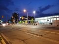
A wider shot at Caledonia

A view south to downtown
Made it!
South from the hashpoint
View north from the hashpoint

Me!

Fairbank station


Achievements
Frogman earned the Subdivision geohash achievement
|
Frogman earned the Public transport geohash achievement
|
- Jump up ↑ Contrast with Regional geohashing achievement for reaching all graticules in a certain area and Reverse regional achievement for reaching all political subdivisions of a certain level within a given graticule.