Difference between revisions of "2024-05-29 45 -121"
Michael5000 (talk | contribs) (→Achievements) |
m |
||
| (7 intermediate revisions by 3 users not shown) | |||
| Line 1: | Line 1: | ||
{{meetup graticule|date=2024-05-29|lat=45|lon=-121}} | {{meetup graticule|date=2024-05-29|lat=45|lon=-121}} | ||
== Location == | == Location == | ||
| − | + | On Robins Island, at Bonneville Dam. | |
== Participants == | == Participants == | ||
| Line 8: | Line 8: | ||
== Expedition == | == Expedition == | ||
| − | + | I took a long break from work at three, and took off east from the city with Mrs.5000 to Bonneville Dam, a great wonder of Depression-Era hydroelectric engineering in the Columbia River Gorge. This time of year, you can usually do this sort of thing after work at our latitude, but access to the dam complex ends at five. It's almost a [[Restricted area achievement]] sort of situation, as you have to check in at a security gate, but the only restriction is that you don't have any firearms, fireworks, or drone aircraft. We didn't, so we were able to roll on in. | |
| + | |||
| + | We visited the hashpoint itself first, then continued on to the main spillway, which is impressively thunderous. By then it was starting to get towards five o'clock, so we started back towards town. Naturally -- for Americans of a certain age -- we listened to Woody Guthrie's "Roll On, Columbia" on the way home. | ||
== Photos == | == Photos == | ||
<gallery perrow="5"> | <gallery perrow="5"> | ||
| − | File:2024-05-29 45 -121 a.jpg | + | File:2024-05-29 45 -121 a.jpg|Arriving at Robins Island |
| − | File:2024-05-29 45 -121 b.jpg | + | File:2024-05-29 45 -121 b.jpg|The 5000s at the hashpoint |
| − | File:2024-05-29 45 -121 c.jpg | + | File:2024-05-29 45 -121 c.jpg|Triumphant hashscot |
| − | File:2024-05-29 45 -121 d.jpg | + | File:2024-05-29 45 -121 d.jpg|Lots of foam and rumbling at the main spillway |
| − | File:2024-05-29 45 -121 e.jpg | + | File:2024-05-29 45 -121 e.jpg|The guardpost |
File:2024-05-29 45 -121 f.jpg | File:2024-05-29 45 -121 f.jpg | ||
| Line 23: | Line 25: | ||
== Achievements == | == Achievements == | ||
{{#vardefine:ribbonwidth|100%}} | {{#vardefine:ribbonwidth|100%}} | ||
| − | + | ||
| + | Along with being an intrinsically interesting site, this was also a rare accessible point in the part of our home county that extends into The Dalles graticule. So, after 15 years of geohashing, we finally have all two graticules: | ||
{{Regional geohashing | {{Regional geohashing | ||
| − | | name = | + | | name = [[user:Michael5000|Michael5000]] and [[user:Mrs.5000|Mrs.5000]] |
| − | | region = | + | | region = Multnomah County |
| − | | count = | + | | count = 2 |
| − | | image = | + | | image = 2024-05-29 45 -121 g.JPG |
}} | }} | ||
| + | |||
[[Image:2024-05-29 45 -121 g.JPG]] | [[Image:2024-05-29 45 -121 g.JPG]] | ||
| − | Reverse regional achievement | + | |
| + | It's also obnoxiously close to a [[Reverse regional achievement]] in The Dalles graticule for Michael, almost as close as you can get without feeling like you deserve honorable mention. The few westernmost square kilometers of Sherman County are pretty rugged, and are likely to prove elusive for the duration. Or, who knows! There might be an easy hashpoint there tomorrow! That's geohashing for you. | ||
[[File:2024-05-29 45 -121 h.JPG]] | [[File:2024-05-29 45 -121 h.JPG]] | ||
| + | |||
{| class="wikitable" | {| class="wikitable" | ||
!Name!!Geohash<br />probability | !Name!!Geohash<br />probability | ||
| Line 58: | Line 64: | ||
<ref name="kripakko">[https://kripakko.neocities.org/geohash_regions/ Kripakko's Graticule partitioner]</ref> | <ref name="kripakko">[https://kripakko.neocities.org/geohash_regions/ Kripakko's Graticule partitioner]</ref> | ||
__NOTOC__ | __NOTOC__ | ||
| − | |||
| − | |||
| − | |||
| − | |||
| − | |||
| − | |||
| − | |||
| − | |||
| − | |||
| − | |||
[[Category:Expeditions]] | [[Category:Expeditions]] | ||
| − | |||
[[Category:Expeditions with photos]] | [[Category:Expeditions with photos]] | ||
| − | |||
| − | |||
| − | |||
| − | |||
[[Category:Coordinates reached]] | [[Category:Coordinates reached]] | ||
| − | + | {{location|US|OR|MU}} | |
| − | |||
| − | |||
| − | |||
| − | |||
| − | |||
| − | |||
| − | |||
| − | |||
| − | |||
| − | |||
| − | |||
| − | |||
| − | |||
Latest revision as of 06:28, 31 May 2024
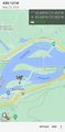
| Wed 29 May 2024 in 45,-121: 45.6378983, -121.9515122 geohashing.info google osm bing/os kml crox |
Location
On Robins Island, at Bonneville Dam.
Participants
Expedition
I took a long break from work at three, and took off east from the city with Mrs.5000 to Bonneville Dam, a great wonder of Depression-Era hydroelectric engineering in the Columbia River Gorge. This time of year, you can usually do this sort of thing after work at our latitude, but access to the dam complex ends at five. It's almost a Restricted area achievement sort of situation, as you have to check in at a security gate, but the only restriction is that you don't have any firearms, fireworks, or drone aircraft. We didn't, so we were able to roll on in.
We visited the hashpoint itself first, then continued on to the main spillway, which is impressively thunderous. By then it was starting to get towards five o'clock, so we started back towards town. Naturally -- for Americans of a certain age -- we listened to Woody Guthrie's "Roll On, Columbia" on the way home.
Photos
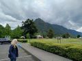
Arriving at Robins Island

The 5000s at the hashpoint
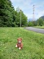
Triumphant hashscot
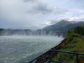
Lots of foam and rumbling at the main spillway
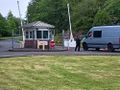
The guardpost


Achievements
Along with being an intrinsically interesting site, this was also a rare accessible point in the part of our home county that extends into The Dalles graticule. So, after 15 years of geohashing, we finally have all two graticules:
Michael5000 and Mrs.5000 earned the Regional geohashing achievement
|

It's also obnoxiously close to a Reverse regional achievement in The Dalles graticule for Michael, almost as close as you can get without feeling like you deserve honorable mention. The few westernmost square kilometers of Sherman County are pretty rugged, and are likely to prove elusive for the duration. Or, who knows! There might be an easy hashpoint there tomorrow! That's geohashing for you.

| Name | Geohash probability |
|---|---|
| ■ Wasco County | 37.2% |
| ■ Klickitat County | 19.1% |
| ■ Hood River County | 15.9% |
| ■ Clackamas County | 12.9% |
| ■ Skamania County | 12.8% |
| ■ Multnomah County | 1.8% |
| ■ Sherman County | 0.21% |