Difference between revisions of "2009-05-17 48 -123"
From Geohashing
imported>Elbie (→Achievements: putting the earned ones up. Still thinking about public transport for all that bussing & ferrying.) |
imported>Elbie (lowest geohash, too!) |
||
| Line 29: | Line 29: | ||
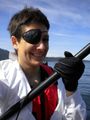
Image:2009-05-17 48 -123 pirate.jpg | Yarr? | Image:2009-05-17 48 -123 pirate.jpg | Yarr? | ||
Image:2009-05-17 48 -123 gps.jpg | At the coordinates. | Image:2009-05-17 48 -123 gps.jpg | At the coordinates. | ||
| + | Image:2009-05-17 48 -123 lowElevation.jpg | Less blurry GPS shot to show my elevation (-6m). | ||
Image:2009-05-17 48 -123 kayak1.jpg | Heading back to land. | Image:2009-05-17 48 -123 kayak1.jpg | Heading back to land. | ||
Image:2009-05-17 48 -123 calendarGirl.jpg | A Calendar Girl photo op while waiting for the kayak to dry. | Image:2009-05-17 48 -123 calendarGirl.jpg | A Calendar Girl photo op while waiting for the kayak to dry. | ||
| Line 36: | Line 37: | ||
==Achievements== | ==Achievements== | ||
{{Water geohash | latitude = 48 | longitude = -123 | date = 2009-05-17 | name = Elbie | image = 2009-05-17 48 -123 kayak1.jpg}} | {{Water geohash | latitude = 48 | longitude = -123 | date = 2009-05-17 | name = Elbie | image = 2009-05-17 48 -123 kayak1.jpg}} | ||
| + | {{Low_Geohash | latitude = 48 | longitude = -123 | date = 2009-05-17 | name = Elbie | image = 2009-05-17 48 -123 lowElevation.jpg | depth = -6m}} | ||
{{Buccaneer geohash | latitude = 48 | longitude = -123 | date = 2009-05-17 | name = Elbie | image = 2009-05-17 48 -123 pirate.jpg | action = paddlin' the seven seas}} | {{Buccaneer geohash | latitude = 48 | longitude = -123 | date = 2009-05-17 | name = Elbie | image = 2009-05-17 48 -123 pirate.jpg | action = paddlin' the seven seas}} | ||
{{Calendar girl | latitude = 48 | longitude = -123 | date = 2009-05-17 | name = Elbie | image = 2009-05-17 48 -123 calendarGirl.jpg}} | {{Calendar girl | latitude = 48 | longitude = -123 | date = 2009-05-17 | name = Elbie | image = 2009-05-17 48 -123 calendarGirl.jpg}} | ||
Revision as of 22:03, 18 May 2009
| Sun 17 May 2009 in 48,-123: 48.7104108, -123.4668811 geohashing.info google osm bing/os kml crox |
Location
Between Saanich Peninsula, and Salt Spring Island.
Participants
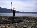
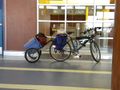
- Elbie, with a bike trailer containing, amazingly enough, a kayak.
The Plan
- 13:00 - ferry leaves Tsawwassen to Swartz Bay
- 15:00 - arrive at the public boat launch on Lands End Road, at the northern tip of the Saanich Peninsula
- hopefully 15:30 - get on the water
- hopefully 16:30 - get to the hashpoint
- 18:00 - start packing up kayak, head back to the ferry terminal
- 19:00 - ferry leaves Swartz Bay to Tsawwassen
Expedition
Abridged: I biked, I bussed, I ferried, I biked some more, then I kayaked, got there, paddled back, biked some more, ferried, bussed, and then biked home.
Proper writeup pending.
Photos
Yarr?
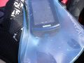
At the coordinates.
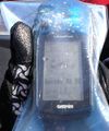
Less blurry GPS shot to show my elevation (-6m).
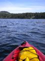
Heading back to land.
A Calendar Girl photo op while waiting for the kayak to dry.
Waited around Swartz Bay for three hours to get on a ferry.


Achievements
Elbie earned the Water geohash achievement
|
Elbie earned the Lowest Geohash Achievement
|
Elbie earned the Buccaneer Geohash Achievement
|
Elbie earned the Calendar girl achievement
|
Elbie earned the Bicycle geohash achievement
|