Difference between revisions of "2009-09-10 51 -1"
imported>Macronencer (Details) |
imported>FippeBot m (Location) |
||
| (12 intermediate revisions by 2 users not shown) | |||
| Line 1: | Line 1: | ||
| + | {{Advert}} | ||
| + | |||
<!-- If you did not specify these parameters in the template, please substitute appropriate things for IMAGE, LAT, LON, and DATE (YYYY-MM-DD format) --> | <!-- If you did not specify these parameters in the template, please substitute appropriate things for IMAGE, LAT, LON, and DATE (YYYY-MM-DD format) --> | ||
<!-- | <!-- | ||
| Line 16: | Line 18: | ||
== Participants == | == Participants == | ||
*[[User:Macronencer|Macronencer]] | *[[User:Macronencer|Macronencer]] | ||
| − | + | *[[User:Sermoa|Sermoa]] | |
| + | *[[User:Mapaholic|Mapaholic]] | ||
== Plans == | == Plans == | ||
[[Midnight Geohash]] planned (at end of day) | [[Midnight Geohash]] planned (at end of day) | ||
| + | |||
| + | [[User:Macronencer|Macronencer]] will pick up [[User:Sermoa|Sermoa]] and [[User:Mapaholic|Mapaholic]] from Winchester at about 11pm. We'll drive up the A34, stop in a little car park, and hike through the woods into the geohash field. Torches, boots and warm clothing will be essential! The weather should be great, few clouds, a waning moon high in the sky. I just hope we can find our way to the hashpoint! | ||
== Expedition == | == Expedition == | ||
| + | Well, this was quite an interesting operation! I planned it quite carefully, except for a few minor details - for example, a driving route that wouldn't have given us access to the chosen parking area, and a very dark strip of woods that we would have had to negotiate! :-P Fortunately, [[User:Sermoa|Sermoa]] spotted a sign that said "parking" so we found somewhere better than the original spot, where we could simply walk down the road. There were occasional pauses to let traffic pass, but it wasn't very busy really. | ||
| + | |||
| + | As the hash field was accessed down a road that led nowhere else but farmland and was flanked by houses at the start, we were judiciously silent at that point. Not that we were doing anything wrong, but we just didn't want any awkward questions. Our cover story was that we were going ghost-hunting at an ancient iron-age hill fort a couple of miles further on, which I thought sounded plausible - but we didn't have to use it. Actually that hill fort (at [http://www.walkingbritain.co.uk/walks/walks/walk_photo/206311/ Ladle Hill]) looks rather interesting, and I would like to go back one day and explore it! | ||
| + | |||
| + | Using my prepared route on the GPS, we found the location swiftly, and with about 15 minutes to spare. We waited a while, looking at the moon and Jupiter through binoculars. It was a nice clear night, with just a few wispy clouds, and the only sound was the quiet roar of the nearby A34. I've always loved the look of the countryside in the moonlight, and I think we were all glad to be there. | ||
| + | |||
| + | The field looked as if it might have been sowed recently, so we were careful to keep to the edges as we made our way to the hash point. When we found it, it was right next to the edge of a separate section of field that had corn growing in it, which was lucky as we didn't have to walk out into the middle and possibly do damage. Photos were taken to prove the time and co-ordinates, and then we walked back to the car in jubilant mood, discussing all kinds of things. There is a traditional British red phone box in Litchfield, and of course we had to go for the phonebox-stuffing achievement, although you could argue that three people isn't really "stuffing" as such! I had brought with me a pebble from [[2009-08-08 50 -2|the hash]] I did with [[User:Sermoa|Sermoa]] in Portland, and I'd written co-ordinates and a page address on it, along with a moon and stars, and the words "The Internet was here - at midnight!" written around the outside. We left it in the phone box, as we were concerned that leaving it on the field might be seen as damage, given the carefully-harrowed state of the soil. TNLN TFTC - oops, sorry, wrong web site. Anyway, we drove home, with quite a large detour I'm sorry to say, as my finger slipped when choosing a location on the TomTom and I nearly sent us back to the hash point! Oops. | ||
| + | |||
| + | My thanks to [[User:Sermoa|Sermoa]] and [[User:Mapaholic|Mapaholic]] for accompanying me on our first midnight hash. Excellent fun! | ||
| + | |||
| + | Photos and my tracklog will follow soon. | ||
| + | |||
| + | --[[User:Macronencer|macronencer]] 11:00, 11 September 2009 (UTC) | ||
== Tracklog == | == Tracklog == | ||
| + | [http://www.gmap-pedometer.com/?r=3178831 walking route tracked on gmap-pedometer] says we walked 1.66 miles / 2.68km from where we parked to the hash point. And of course, exactly the same distance back again! :) | ||
== Photos == | == Photos == | ||
| − | |||
| − | |||
| − | |||
| − | |||
<gallery perrow="4"> | <gallery perrow="4"> | ||
| + | Image:2009-09-10_51_-1_Macronencer_01.jpg | Proof of location | ||
| + | Image:2009-09-10_51_-1_Macronencer_02.jpg | Proof of location at one minute to midnight | ||
| + | Image:2009-09-10_51_-1_Macronencer_03.jpg | Phonebox stuffing | ||
| + | Image:2009-09-10_51_-1_Macronencer_04.jpg | Is it for me? | ||
| + | Image:2009-09-10_51_-1_Macronencer_05.jpg | Marker (A side) | ||
| + | Image:2009-09-10_51_-1_Macronencer_06.jpg | Marker (B side, not so good, but it got some radio play) | ||
| + | </gallery> | ||
| + | |||
| + | == Achievements == | ||
| − | + | {{Midnight geohash | latitude = 51 | longitude = -1 | date = 2009-09-10 | name = Macronencer, Sermoa and Mapaholic | image = 2009-09-10_51_-1_Macronencer_02.jpg }} | |
| − | -- | ||
| + | {{Phonebooth stuffing | latitude = 51 | longitude = -1 | date = 2009-09-10 | name = Macronencer, Sermoa and Mapaholic | image = 2009-09-10_51_-1_Macronencer_03.jpg }} | ||
| − | |||
| − | |||
[[Category:Expeditions]] | [[Category:Expeditions]] | ||
| − | |||
[[Category:Expeditions with photos]] | [[Category:Expeditions with photos]] | ||
| − | |||
| − | |||
| − | |||
| − | |||
| − | |||
[[Category:Coordinates reached]] | [[Category:Coordinates reached]] | ||
| − | + | {{location|GB|ENG|HAM}} | |
| − | |||
| − | |||
| − | |||
| − | |||
| − | |||
| − | |||
| − | |||
| − | |||
| − | |||
Latest revision as of 05:44, 8 August 2019
| Have you seen our geohashing marker? We'd love to hear from you! Click here to say "hi" and tell us what you've seen!
Curious about what geohashing is? Read more! |
| Thu 10 Sep 2009 in 51,-1: 51.2846715, -1.3337987 geohashing.info google osm bing/os kml crox |
Location
Participants
Plans
Midnight Geohash planned (at end of day)
Macronencer will pick up Sermoa and Mapaholic from Winchester at about 11pm. We'll drive up the A34, stop in a little car park, and hike through the woods into the geohash field. Torches, boots and warm clothing will be essential! The weather should be great, few clouds, a waning moon high in the sky. I just hope we can find our way to the hashpoint!
Expedition
Well, this was quite an interesting operation! I planned it quite carefully, except for a few minor details - for example, a driving route that wouldn't have given us access to the chosen parking area, and a very dark strip of woods that we would have had to negotiate! :-P Fortunately, Sermoa spotted a sign that said "parking" so we found somewhere better than the original spot, where we could simply walk down the road. There were occasional pauses to let traffic pass, but it wasn't very busy really.
As the hash field was accessed down a road that led nowhere else but farmland and was flanked by houses at the start, we were judiciously silent at that point. Not that we were doing anything wrong, but we just didn't want any awkward questions. Our cover story was that we were going ghost-hunting at an ancient iron-age hill fort a couple of miles further on, which I thought sounded plausible - but we didn't have to use it. Actually that hill fort (at Ladle Hill) looks rather interesting, and I would like to go back one day and explore it!
Using my prepared route on the GPS, we found the location swiftly, and with about 15 minutes to spare. We waited a while, looking at the moon and Jupiter through binoculars. It was a nice clear night, with just a few wispy clouds, and the only sound was the quiet roar of the nearby A34. I've always loved the look of the countryside in the moonlight, and I think we were all glad to be there.
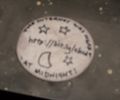
The field looked as if it might have been sowed recently, so we were careful to keep to the edges as we made our way to the hash point. When we found it, it was right next to the edge of a separate section of field that had corn growing in it, which was lucky as we didn't have to walk out into the middle and possibly do damage. Photos were taken to prove the time and co-ordinates, and then we walked back to the car in jubilant mood, discussing all kinds of things. There is a traditional British red phone box in Litchfield, and of course we had to go for the phonebox-stuffing achievement, although you could argue that three people isn't really "stuffing" as such! I had brought with me a pebble from the hash I did with Sermoa in Portland, and I'd written co-ordinates and a page address on it, along with a moon and stars, and the words "The Internet was here - at midnight!" written around the outside. We left it in the phone box, as we were concerned that leaving it on the field might be seen as damage, given the carefully-harrowed state of the soil. TNLN TFTC - oops, sorry, wrong web site. Anyway, we drove home, with quite a large detour I'm sorry to say, as my finger slipped when choosing a location on the TomTom and I nearly sent us back to the hash point! Oops.
My thanks to Sermoa and Mapaholic for accompanying me on our first midnight hash. Excellent fun!
Photos and my tracklog will follow soon.
--macronencer 11:00, 11 September 2009 (UTC)
Tracklog
walking route tracked on gmap-pedometer says we walked 1.66 miles / 2.68km from where we parked to the hash point. And of course, exactly the same distance back again! :)
Photos
Achievements
Macronencer, Sermoa and Mapaholic earned the Midnight Geohash achievement
|
Macronencer, Sermoa and Mapaholic earned the Phonebooth stuffing achievement
|


