imported>Sourcerer |
imported>Sourcerer |
| Line 49: |
Line 49: |
| | === February === | | === February === |
| | | | |
| | + | * {{Planning|268/306}} [[2016-02-13 52 1|2016-02-13]] (Friday): [[User:Sourcerer|Sourcerer]] A wood between Hoveton and Horning, Norfolk, UK. |
| | * {{Planning|267/305}} [[2016-02-12 52 1|2016-02-12]] (Friday): [[User:Sourcerer|Sourcerer]] A wood south of Beccles, Suffolk, UK. | | * {{Planning|267/305}} [[2016-02-12 52 1|2016-02-12]] (Friday): [[User:Sourcerer|Sourcerer]] A wood south of Beccles, Suffolk, UK. |
| | * {{Reached|266/304}} [[2016-02-11 52 1|2016-02-11]] (Thursday): [[User:Sourcerer|Sourcerer]] A field north of Woodbridge, Suffolk, UK. | | * {{Reached|266/304}} [[2016-02-11 52 1|2016-02-11]] (Thursday): [[User:Sourcerer|Sourcerer]] A field north of Woodbridge, Suffolk, UK. |
Revision as of 17:11, 12 February 2016
About Norwich
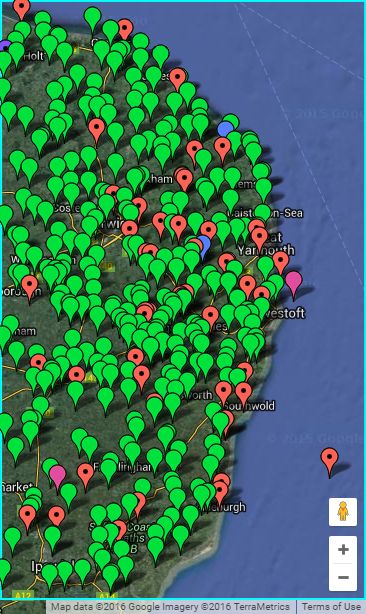
The 52,1 graticule covers the parts of the United Kingdom from 52° to 53° latitude, and from 1° to 2° longitude. This includes parts of Norfolk and Suffolk with their coastlines. The Reverse regional achievement is easily achieved by geohashing both these counties. 57% is land. In an average month there might be 17 land geohashes with 15 reachable so it's a "coin toss" whether or not you can reach coordinates on any given day. The north coast is in sea area Humber. The east is Thames.
Most of the terrain is agricultural. Some areas are very flat. Other areas include low rolling hills. This easy terrain, full of public footpaths, is balanced by coastal mud flats and salt marshes which can be tricky to reach. The Norfolk and Suffolk Broads cover a sizeable area with rivers, canals and man-made broads (lakes) created by peat digging.
2016 Expeditions
If you're planning an expedition, please add to this section. People actively watch it and they might try to join you. Binomial Stat's Calculator.
Planning Reached Not reached Retro
May
All geohashers are cordially invited to the 10th anniversary 2018 geohashing day meetup in the Cambridge UK graticule.
February
- 268/306 2016-02-13 (Friday): Sourcerer A wood between Hoveton and Horning, Norfolk, UK.
- 267/305 2016-02-12 (Friday): Sourcerer A wood south of Beccles, Suffolk, UK.
- 266/304 2016-02-11 (Thursday): Sourcerer A field north of Woodbridge, Suffolk, UK.
- 265/303 2016-02-10 (Wednesday): Sourcerer A field south east of Gipping, 3km from source of the Gipping river, Suffolk, UK.
- 264/302 2016-02-03 (Wednesday): Sourcerer A field east of Ingham Corner, Norfolk, UK.
- 263/301 2016-02-02 (Tuesday): Sourcerer A field north of Thorpe Market, Norfolk, UK.
2016 Monthly Archives
Annual Expedition Archives
| Present Year
|
Total
|
Expeditions
|
Reached
|
Retro
|
Retro Reached
|
Expeditions retro-visited
|
| 2016
|
141
|
140
|
121
|
1
|
1
|
5
|
| 2015
|
178
|
178
|
155
|
0
|
0
|
12
|
| 2014
|
15
|
15
|
14
|
0
|
0
|
2
|
| 2013
|
22
|
21
|
19
|
1
|
1
|
1
|
| 2012
|
22
|
22
|
18
|
0
|
0
|
1
|
| 2011
|
25
|
25
|
21
|
0
|
0
|
0
|
| 2010
|
25
|
24
|
21
|
1
|
1
|
2
|
| 2009
|
2
|
2
|
2
|
0
|
0
|
0
|
Graticule Level Achievements
2016
2015
2013
2011
Local Geohashers
- Aaronboardley, based in Lowestoft.
- Benjw, based in Cambridge, has visited this graticule.
- ChromeCrusaders, based in Great Yarmouth, Norfolk.
- Homonecloco probably visited 2014-05-17 52 1.
- Jaydublu, based on the North Norfolk coast, doesn't do boats or Suffolk.
- MagicIan, based in Mulbarton, just south of Norwich. His Geohashing exploits are sporadic to say the least.
- PaintedJaguar, based in the Cambridge graticule.
- Sourcerer, lives in Bungay, Suffolk. He visits local hashpoints and on his travels, any hashpoint near enough to reach.
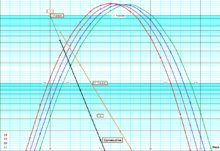
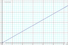
Graticule Statistical Charts
Check out the probabilities of getting consecutive hashpoints and find out how likely it is to get certain numbers of land hashpoints in a month.
This CALCULATOR was used to generate the statistics.