Difference between revisions of "2014-12-28 28 -16"
imported>Sourcerer m (→Added Proof and Photos) |
imported>FippeBot m (Location) |
||
| (3 intermediate revisions by one other user not shown) | |||
| Line 3: | Line 3: | ||
| lon=-16 | | lon=-16 | ||
| date=2014-12-28 | | date=2014-12-28 | ||
| + | | graticule_name=Santa Cruz de Tenerife, Spain | ||
| + | | graticule_link=Santa Cruz de Tenerife, Spain | ||
}} | }} | ||
| − | + | __NOTOC__ | |
== Location == | == Location == | ||
| Line 16: | Line 18: | ||
This hashpiont was 3000km from home but only 25km from my holiday accommodation. I walked about 1km to the Estacion de Guaguas (Bus Station) and caught the 09:30 guagua to Los Christianos. From there it was about 3.5km to the hashpoint. The walk started through holiday accommodation but quickly turned into a mountain path, rocky and steep but not dangerous. The hashpoint was easily found and it was marked with a naturally occuring upside down Google pin made out of solidified volcanic lava. The route home was less easy. A circular route looked possible and indeed it was but I aborted several tracks due to steep ravines. A fitter walker could get through but not a 100kg 61 year old fat bastard! | This hashpiont was 3000km from home but only 25km from my holiday accommodation. I walked about 1km to the Estacion de Guaguas (Bus Station) and caught the 09:30 guagua to Los Christianos. From there it was about 3.5km to the hashpoint. The walk started through holiday accommodation but quickly turned into a mountain path, rocky and steep but not dangerous. The hashpoint was easily found and it was marked with a naturally occuring upside down Google pin made out of solidified volcanic lava. The route home was less easy. A circular route looked possible and indeed it was but I aborted several tracks due to steep ravines. A fitter walker could get through but not a 100kg 61 year old fat bastard! | ||
| + | |||
| + | == Achievements == | ||
| + | |||
| + | {{OpenStreetMap achievement | ||
| + | | latitude = 28 | ||
| + | | longitude = -16 | ||
| + | | date = 2014-12-28 | ||
| + | | OSMlink = 27957557 | ||
| + | | name = Sourcerer | ||
| + | }} | ||
== Photos == | == Photos == | ||
| Line 28: | Line 40: | ||
</gallery> | </gallery> | ||
| − | == | + | {{Sourcerer_links |
| − | + | | prev = 2014-12-09 52 1 | |
| − | + | | curr = 2014-12-28 28 -16 | |
| + | | next = 2015-01-01 28 -16 | ||
| + | | date = 2014-12-28 | ||
| + | }} | ||
[[Category:Expeditions]] | [[Category:Expeditions]] | ||
[[Category:Expeditions with photos]] | [[Category:Expeditions with photos]] | ||
[[Category:Coordinates reached]] | [[Category:Coordinates reached]] | ||
| + | {{location|ES|CN|TF}} | ||
Latest revision as of 02:16, 15 August 2019
| Sun 28 Dec 2014 in Santa Cruz de Tenerife, Spain: 28.0301417, -16.6937423 geohashing.info google osm bing/os kml crox |
Location
Between Los Christianos and Palm Mar, Santa Cruz de Tenerife, España.
Participants
Expedition
This hashpiont was 3000km from home but only 25km from my holiday accommodation. I walked about 1km to the Estacion de Guaguas (Bus Station) and caught the 09:30 guagua to Los Christianos. From there it was about 3.5km to the hashpoint. The walk started through holiday accommodation but quickly turned into a mountain path, rocky and steep but not dangerous. The hashpoint was easily found and it was marked with a naturally occuring upside down Google pin made out of solidified volcanic lava. The route home was less easy. A circular route looked possible and indeed it was but I aborted several tracks due to steep ravines. A fitter walker could get through but not a 100kg 61 year old fat bastard!
Achievements
Sourcerer earned the OpenStreetMap achievement
|
Photos
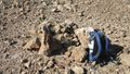
The GPSR is sitting on the Haspoint

Proof
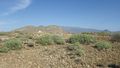
Nearby Terrain
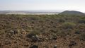
Nearby Terrain with Bananas under nets in the distance
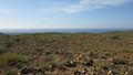
Nearby Terrain
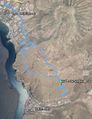
Track Log in Google Earth with a small Caldera visible.


Expeditions and Plans
| 2014-12-28 | ||
|---|---|---|
| Santa Cruz de Tenerife, Spain | Sourcerer | Between Los Christianos and Palm Mar, Santa Cruz de Tenerife, España. |
| Big Rapids, Michigan | Mcbaneg, Rebekah, Katja, Susanne, Pat, Sandy, Sam | Parking lot of a charity-thrift store , Alpine Township, MI, USA |
| Mannheim, Germany | DODO | On a field next to Bretten |
Sourcerer's Expedition Links
2014-12-09 52 1 - 2014-12-28 28 -16 - 2015-01-01 28 -16 - KML file download of Sourcerer's expeditions for use with Google Earth.