Difference between revisions of "2020-03-10 50 -0"
Macronencer (talk | contribs) (→Tracklog: Add tracklog) |
Macronencer (talk | contribs) m (→Achievements: Add Land Geohash) |
||
| (7 intermediate revisions by 2 users not shown) | |||
| Line 1: | Line 1: | ||
| − | + | [[Image:{{{image|2020-03-10_50_-0_Macronencer_10_First_view_of_hash.jpg}}}|thumb|left]] | |
| − | + | __NOTOC__ | |
| − | [[Image:{{{image| | + | {{meetup graticule |
| − | |||
| − | |||
| − | |||
| − | |||
| − | |||
| − | |||
| lat=50 | | lat=50 | ||
| lon=-0 | | lon=-0 | ||
| date=2020-03-10 | | date=2020-03-10 | ||
}}<!-- edit as necessary --> | }}<!-- edit as necessary --> | ||
| − | + | ||
== Location == | == Location == | ||
<!-- where you've surveyed the hash to be --> | <!-- where you've surveyed the hash to be --> | ||
| Line 27: | Line 21: | ||
== Expedition == | == Expedition == | ||
| − | + | ||
| − | + | === [[User:Macronencer|Macronencer]]'s journey === | |
| + | |||
| + | I wasn’t going to go hashing today... yes, that old refrain! The thing is, when you have a week off work and want to get fit again, it almost seems like an obligation. | ||
| + | |||
| + | [[Image:2020-03-10_50_-0_Macronencer_06_Jupiter.jpg|thumb|left]]Today’s hash point was close to a place with which I’m very familiar: [[https://en.wikipedia.org/wiki/Queen_Elizabeth_Country_Park Queen Elizabeth Country Park]]. This wonderful area of natural beauty and recreation sits just east of the A3, north of Portsmouth. I’ve been there a few times, and I know someone who has worked there as well. I was hoping to bump into him today as I haven’t seen him for a while, but he didn’t seem to be around. | ||
| + | |||
| + | I took a scenic route across country to reach the park, and later on when I looked at it, I realised that, with a few modifications, it might have qualified me for the [[Juggernaut_achievement]]. That’s something I’d like to get, one day. Never mind! There was a little drizzle, but it eased off before long. | ||
| + | |||
| + | My original plan had been to park in [[https://www.butserancientfarm.co.uk/ Butser Ancient Farm]], a wonderful place where they re-create historic methods of farming and building, and also have amazing events like Norse and Saxon storytelling, and in May this year, the burning of a Wicker Man :-O It’s where I’d hoped to find my friend, but not only was he not there, there were also several coachloads of children and the car park was full. A friendly staff member, when I mentioned that I was “from the internet”, advised me to park in Chalton and walk back down the road. The path that runs past the hash point, you see, ends up on this road. However, when I’d driven to Chalton I thought it would be too dangerous to walk back along the road, which, though not busy, had lots of blind spots and was about a mile long. So I turned round and headed back up the A3 a short way to enter QECP. | ||
| + | |||
| + | I’d already worked out that the path I wanted to walk was the same one I’d walked years ago with my son: the Space Trail! It’s a clever idea. They begin with the Sun at the car park (it’s carved on a post), and as you walk round, you encounter all the planets, spaced at the correct intervals to match the orbit of Earth. The result is that you see Mercury, Venus and Earth, and then Mars, before you’re properly out of the information centre grounds, and then have to walk quite a way before reaching Jupiter. To see the whole Solar System you have to walk quite a distance! The path I needed jutted south from one corner of the woodland, into some fields, and reaching it wasn’t too much effort (although once again, the February rains had created a load of mud). | ||
| + | |||
| + | As soon as I saw the hash point, I knew there was a potential problem. There were two long gates between me and my destination! They had barbed wire across the top, but they were unlocked and there were no signs. I later figured the barbed wire was probably just to stop people climbing over. I have a natural anxiety about breaking rules, so at first I looked about for an alternative route... but it seemed there wasn’t one. The closest I could get while on the path was 45m away, which was a CNR. While I thought things through, I watched a buzzard hunting. Couldn’t get a good photo, sadly. Maybe I should put my DSLT camera and telephoto lens back into service... | ||
| + | |||
| + | In the end, I got a little annoyed with my own trepidation, and just went through the gates. After all, there were no animals or crops in the fields: it was rough pasture. I’m so glad I took that step! I reached the hash point at last, and was able to walk back to the car happy. On the way, I saw deer tracks, and shot some video of a really nice quiet bit of forest. There was a sign up on one of the trackside trees that suggested making a work of art from leaves and twigs, and photographing it. So I did. I made an XKCD marker :) | ||
| + | |||
| + | <blockquote>'''A quick aside – how to make an XKCD marker from twigs.''' | ||
| + | Find 7 twigs, in a 2-3-2 size pattern. The three middle-sized ones (call them 1 unit) should be just long enough to break in half and make an angle: these will form the crook of “k”, the “c”, and the loop of “d”. The two smallest ones (about 0.8 units) form the “x”. The two longest ones (about 1.2 units) form the verticals of “k” and “d”. Just remember “2-3-2” and you’ve got it!</blockquote> | ||
| + | |||
| + | All in all, a nice trip despite another rather dull day. At least I haven’t been rained on this week yet! | ||
== Tracklog == | == Tracklog == | ||
| Line 39: | Line 52: | ||
--> | --> | ||
<gallery perrow="5"> | <gallery perrow="5"> | ||
| + | Image:2020-03-10 50 -0 Macronencer 01 Satellite view.png | View from orbit | ||
| + | Image:2020-03-10 50 -0 Macronencer 02 Map view.png | Map view showing footpaths | ||
| + | Image:2020-03-10 50 -0 Macronencer 03 QECP.jpg | Queen Elizabeth Country Park is a splendid place to bring the family, especially in the summer! | ||
| + | Image:2020-03-10 50 -0 Macronencer 04 Earth post.jpg | We are just passing planet Earth | ||
| + | Image:2020-03-10 50 -0 Macronencer 05 Trail markers.jpg | Trail markers. The one at the bottom is the Space Trail! | ||
| + | Image:2020-03-10 50 -0 Macronencer 06 Jupiter.jpg | We have arrived at Jupiter. Remember, kids... attempt no landing on Europa. | ||
| + | Image:2020-03-10 50 -0 Macronencer 07 Fork in track.jpg | My life recently seems to consist of taking the muddier of two tracks at a fork. | ||
| + | Image:2020-03-10 50 -0 Macronencer 08 Swamp.jpg | I was right. This one's muddier. But not as muddy as [[1965-05-06_50_-2#Expedition|yesterday!]] | ||
| + | Image:2020-03-10 50 -0 Macronencer 09 The path ahead.jpg | I couldn't make out whether that was water at the bottom. Luckily (kinda) it was more mud. | ||
| + | Image:2020-03-10 50 -0 Macronencer 10 First view of hash.jpg | My first view of the hash point. It's just in front of that copse, at the left end. | ||
| + | Image:2020-03-10 50 -0 Macronencer 11 Pano of hash.jpg | Panorama of hash point | ||
| + | Image:2020-03-10 50 -0 Macronencer 12 Rear of copse pano.jpg | I surveyed the other side of the copse, in case there was easier access. It was fenced in like Area 51. I considered a Naruto Run, but I think the barbed wire might have had something to say about that. | ||
| + | Image:2020-03-10 50 -0 Macronencer 13 Thwarted so far.png | As close as I could get while still on the path and chickening out. | ||
| + | Image:2020-03-10 50 -0 Macronencer 14 Two gates.jpg | Two gates stand between Macronencer and Glory. They're both unlocked, with no warning signs. Can he overcome his fear of breaking rules? | ||
| + | Image:2020-03-10 50 -0 Macronencer 15 Proof.png | Yes, he can! | ||
| + | Image:2020-03-10 50 -0 Macronencer 16 Me at hash point.jpg | Jubilant at the hash point! | ||
| + | Image:2020-03-10 50 -0 Macronencer 17 Pano from hash.jpg | Panorama from the hash point | ||
| + | Image:2020-03-10 50 -0 Macronencer 18 Chuck.jpg | Chuck, taking a breather in the grass. | ||
| + | Image:2020-03-10 50 -0 Macronencer 19 More mud.jpg | Here we slip again... | ||
| + | Image:2020-03-10 50 -0 Macronencer 20 Woodland BW.jpg | Arty shot | ||
| + | Image:2020-03-10 50 -0 Macronencer 21 Nice idea.jpg | Hey, what a great idea! Make your own art from natural resources. | ||
| + | Image:2020-03-10 50 -0 Macronencer 22 Couldnt resist.jpg | I made my own art from natural resources. | ||
| + | Image:2020-03-10 50 -0 Macronencer 23 Not at the hash marker.jpg | Haha! I wonder what people will make of that. | ||
| + | Image:2020-03-10 50 -0 Macronencer 24 Deer tracks I think.jpg | Are these deer tracks? | ||
| + | Image:2020-03-10 50 -0 Macronencer 25 Moss tentacles.jpg | Moss Tentacles. These looked amazing. | ||
| + | Image:2020-03-10 50 -0 Macronencer 26 Flower.jpg | I like this flower against the spiky background. | ||
| + | Image:2020-03-10 50 -0 Macronencer 27 Peaceful wood pano.jpg | I really love woodland like this. | ||
| + | Image:2020-03-10 50 -0 Macronencer 28 No stupid sign.jpg | No stupid Keep Out sign that actually means it-is-forbidden-to-prevent-people-entering this time. I approve. | ||
</gallery> | </gallery> | ||
== Achievements == | == Achievements == | ||
{{#vardefine:ribbonwidth|800px}} | {{#vardefine:ribbonwidth|800px}} | ||
| − | |||
| − | + | {{land geohash|latitude=50|longitude=-0|date=2020-03-10|name=[[User:Macronencer|Macronencer]]|image=2020-03-10 50 -0 Macronencer 16 Me at hash point.jpg}} | |
| − | + | {{Two to the N achievement|count=5|date=2020-03-10|latitude=50|longitude=-0|name=Macronencer|reached=true}} | |
| − | |||
| − | |||
| − | |||
| − | |||
| − | |||
| − | |||
| − | |||
| − | |||
[[Category:Expeditions]] | [[Category:Expeditions]] | ||
| − | |||
[[Category:Expeditions with photos]] | [[Category:Expeditions with photos]] | ||
| − | |||
| − | |||
| − | |||
| − | |||
| − | |||
[[Category:Coordinates reached]] | [[Category:Coordinates reached]] | ||
| − | + | {{location|GB|ENG|HAM}} | |
| − | |||
| − | |||
| − | |||
| − | |||
| − | |||
| − | |||
| − | |||
| − | |||
| − | |||
| − | |||
| − | |||
| − | |||
| − | |||
| − | |||
| − | |||
| − | |||
Latest revision as of 11:00, 14 March 2020

| Tue 10 Mar 2020 in 50,-0: 50.9497914, -0.9745668 geohashing.info google osm bing/os kml crox |
Location
Next to some trees near a footpath close to the Queen Elizabeth Country Park visitor centre.
Participants
Macronencer is planning to go.
Plans
Macronencer plans to visit, and perhaps call on a friend who works in the park. Said friend might even assist with a drag-along achievement, and/or lend a hand with permission, should there be any access issues.
Expedition
Macronencer's journey
I wasn’t going to go hashing today... yes, that old refrain! The thing is, when you have a week off work and want to get fit again, it almost seems like an obligation.

Today’s hash point was close to a place with which I’m very familiar: [Queen Elizabeth Country Park]. This wonderful area of natural beauty and recreation sits just east of the A3, north of Portsmouth. I’ve been there a few times, and I know someone who has worked there as well. I was hoping to bump into him today as I haven’t seen him for a while, but he didn’t seem to be around.
I took a scenic route across country to reach the park, and later on when I looked at it, I realised that, with a few modifications, it might have qualified me for the Juggernaut_achievement. That’s something I’d like to get, one day. Never mind! There was a little drizzle, but it eased off before long.
My original plan had been to park in [Butser Ancient Farm], a wonderful place where they re-create historic methods of farming and building, and also have amazing events like Norse and Saxon storytelling, and in May this year, the burning of a Wicker Man :-O It’s where I’d hoped to find my friend, but not only was he not there, there were also several coachloads of children and the car park was full. A friendly staff member, when I mentioned that I was “from the internet”, advised me to park in Chalton and walk back down the road. The path that runs past the hash point, you see, ends up on this road. However, when I’d driven to Chalton I thought it would be too dangerous to walk back along the road, which, though not busy, had lots of blind spots and was about a mile long. So I turned round and headed back up the A3 a short way to enter QECP.
I’d already worked out that the path I wanted to walk was the same one I’d walked years ago with my son: the Space Trail! It’s a clever idea. They begin with the Sun at the car park (it’s carved on a post), and as you walk round, you encounter all the planets, spaced at the correct intervals to match the orbit of Earth. The result is that you see Mercury, Venus and Earth, and then Mars, before you’re properly out of the information centre grounds, and then have to walk quite a way before reaching Jupiter. To see the whole Solar System you have to walk quite a distance! The path I needed jutted south from one corner of the woodland, into some fields, and reaching it wasn’t too much effort (although once again, the February rains had created a load of mud).
As soon as I saw the hash point, I knew there was a potential problem. There were two long gates between me and my destination! They had barbed wire across the top, but they were unlocked and there were no signs. I later figured the barbed wire was probably just to stop people climbing over. I have a natural anxiety about breaking rules, so at first I looked about for an alternative route... but it seemed there wasn’t one. The closest I could get while on the path was 45m away, which was a CNR. While I thought things through, I watched a buzzard hunting. Couldn’t get a good photo, sadly. Maybe I should put my DSLT camera and telephoto lens back into service...
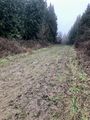
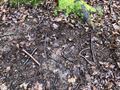
In the end, I got a little annoyed with my own trepidation, and just went through the gates. After all, there were no animals or crops in the fields: it was rough pasture. I’m so glad I took that step! I reached the hash point at last, and was able to walk back to the car happy. On the way, I saw deer tracks, and shot some video of a really nice quiet bit of forest. There was a sign up on one of the trackside trees that suggested making a work of art from leaves and twigs, and photographing it. So I did. I made an XKCD marker :)
A quick aside – how to make an XKCD marker from twigs. Find 7 twigs, in a 2-3-2 size pattern. The three middle-sized ones (call them 1 unit) should be just long enough to break in half and make an angle: these will form the crook of “k”, the “c”, and the loop of “d”. The two smallest ones (about 0.8 units) form the “x”. The two longest ones (about 1.2 units) form the verticals of “k” and “d”. Just remember “2-3-2” and you’ve got it!
All in all, a nice trip despite another rather dull day. At least I haven’t been rained on this week yet!
Tracklog
Photos
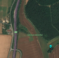
View from orbit
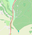
Map view showing footpaths
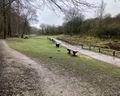
Queen Elizabeth Country Park is a splendid place to bring the family, especially in the summer!
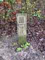
We are just passing planet Earth
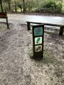
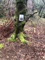
Trail markers. The one at the bottom is the Space Trail!
We have arrived at Jupiter. Remember, kids... attempt no landing on Europa.
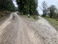
My life recently seems to consist of taking the muddier of two tracks at a fork.
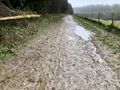
I was right. This one's muddier. But not as muddy as yesterday!
I couldn't make out whether that was water at the bottom. Luckily (kinda) it was more mud.
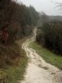
My first view of the hash point. It's just in front of that copse, at the left end.
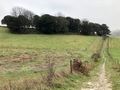
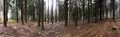
Panorama of hash point
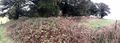
I surveyed the other side of the copse, in case there was easier access. It was fenced in like Area 51. I considered a Naruto Run, but I think the barbed wire might have had something to say about that.

As close as I could get while still on the path and chickening out.
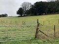
Two gates stand between Macronencer and Glory. They're both unlocked, with no warning signs. Can he overcome his fear of breaking rules?

Yes, he can!
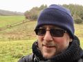
Jubilant at the hash point!
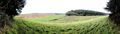
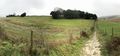
Panorama from the hash point

Chuck, taking a breather in the grass.
Here we slip again...
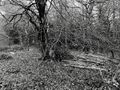
Arty shot
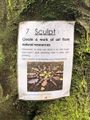
Hey, what a great idea! Make your own art from natural resources.
I made my own art from natural resources.
Haha! I wonder what people will make of that.
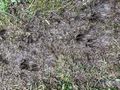
Are these deer tracks?
Moss Tentacles. These looked amazing.
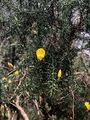
I like this flower against the spiky background.
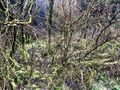
I really love woodland like this.

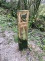
No stupid Keep Out sign that actually means it-is-forbidden-to-prevent-people-entering this time. I approve.


Achievements
Macronencer earned the Land geohash achievement
|
