Difference between revisions of "2020-09-09 51 -1"
m (Location) |
(Linked blog; added The Internet Was Here advert) |
||
| (3 intermediate revisions by the same user not shown) | |||
| Line 1: | Line 1: | ||
| − | {{meetup graticule | + | {{User:DanQ/Template:DanQBlog | url = https://danq.me/2020/09/09/geohashing-expedition-2020-09-09-51-1/ }} |
| + | {{advert}}{{meetup graticule | ||
|lat=51 | |lat=51 | ||
|lon=-1 | |lon=-1 | ||
| Line 8: | Line 9: | ||
== Participants == | == Participants == | ||
| − | *[[User:DanQ| | + | *[[User:DanQ|Dan Q]] |
== Plans == | == Plans == | ||
| Line 16: | Line 17: | ||
== Expedition == | == Expedition == | ||
| − | ...to | + | I worked hard to clear an hour of my day to take a trip, then jumped in my (new) electric car and set off towards the hashpoint. As I passed Newbridge I briefly considered stopping and checking up on [https://danq.me/geo/sunken-bunker/ my geocache there] but feeling pressed for time I decided to push on. I parked in the lay-by where GC5XHJG is apparently hidden but [https://www.geocaching.com/seek/log.aspx?LUID=e7bec7ce-0512-4c03-b746-10c895389cd0 couldn't find it]: I didn't search for long because the farmer in the adjacent field was watching me with suspicion and I figured that anyway I could hunt for it on the way back. |
| − | + | ||
| + | Walking along the A338 was treacherous! There are no paths, only a verge covered in thick grass and spiky plants, and a significant number of the larger vehicles (and virtually all of the motorbikes) didn't seem to be obeying the 60mph speed limit! | ||
| + | |||
| + | Reaching the gate, I crawled under (reckoning that it's probably there to stop vehicles and not humans) and wandered along the lane. I saw a red kite and a heron doing their thing before I reached the bridge, crossed Letcombe Brook, and followed the edge of the field. Stuffing my face with blackberries as I went, it wasn't long before I reached the hashpoint on one edge of the field. | ||
| + | |||
| + | I took a short-cut back before realising that this would put me in the wrong place to leave a The Internet Was Here sign, so I doubled-back to place it on the gate I'd crawled under. Then I returned to the lay-by, where another car had just pulled up (right over the GZ of the geocache I'd hoped to find!) and didn't seem to be going anywhere. Sadly I couldn't wait around all day - I had work to do! - so I went home, following the satnav in the car in a route that resulted in a figure-of-eight tracklog. | ||
== Tracklog == | == Tracklog == | ||
| − | ... | + | My GPS keeps a tracklog. Here you go: |
| − | + | * [[File:Track GH 2020-09-09 51 -1.gpx|Track GH 2020-09-09 51 -1.gpx]] | |
| + | [[File:Gh-2020-09-09-51--1-map.jpg|frameless]] | ||
| + | |||
| + | == Video == | ||
| + | <youtube>https://youtu.be/eDfy9oP2cig</youtube> | ||
| + | |||
| + | Also available on: | ||
| + | * [https://tube.danq.me/videos/watch/5b332f7d-85cb-4eff-b5de-b387a86bfd0b QTube] | ||
| + | * [https://youtu.be/eDfy9oP2cig YouTube] | ||
== Photos == | == Photos == | ||
| − | |||
| − | |||
| − | |||
| − | |||
<gallery perrow='5'> | <gallery perrow='5'> | ||
| + | Image:2020-09-09 51 -1 silly grin.jpg | Look, I made it! | ||
| + | Image:2020-09-09-51---1 R0010081 20200909100119.JPG | Panoramic (360°)) photo of the hashpoint, silly grin included | ||
| + | Image:2020-09-09 51 -1 the internet was here.jpg | The Internet Was Here | ||
</gallery> | </gallery> | ||
== Achievements == | == Achievements == | ||
| − | |||
{{#vardefine:ribbonwidth|100%}} | {{#vardefine:ribbonwidth|100%}} | ||
| − | + | {{gratuitous ribbon | |
| + | | color = red | ||
| + | | icon = Electric_car.png | ||
| + | | latitude = 51 | ||
| + | | longitude = -1 | ||
| + | | date = 2020-09-09 | ||
| + | | achievement = Electric Vehicle Achievement | ||
| + | | description = travelling to and from the Geohash in an electric vehicle | ||
| + | | name = DanQ | ||
| + | }} | ||
| − | [[ | + | (I'm totally claiming the [[Subdivision geohash achievement]] once it's confirmed, too...) |
| − | |||
[[Category:Expeditions]] | [[Category:Expeditions]] | ||
| − | |||
[[Category:Expeditions with photos]] | [[Category:Expeditions with photos]] | ||
[[Category:Expeditions with videos]] | [[Category:Expeditions with videos]] | ||
| − | |||
| − | |||
| − | |||
| − | |||
[[Category:Coordinates reached]] | [[Category:Coordinates reached]] | ||
| − | |||
| − | |||
| − | |||
| − | |||
| − | |||
| − | |||
| − | |||
| − | |||
| − | |||
| − | |||
| − | |||
| − | |||
| − | |||
| − | |||
| − | |||
| − | |||
{{location|GB|ENG|OXF}} | {{location|GB|ENG|OXF}} | ||
Latest revision as of 15:06, 9 September 2020
|
Dan Q also wrote about this expedition on his blog. For more details and higher-resolution pictures, see this expedition's log at https://danq.me/2020/09/09/geohashing-expedition-2020-09-09-51-1/ |
| Have you seen our geohashing marker? We'd love to hear from you! Click here to say "hi" and tell us what you've seen!
Curious about what geohashing is? Read more! |
| Wed 9 Sep 2020 in 51,-1: 51.6460691, -1.3886555 geohashing.info google osm bing/os kml crox |
Location
Edge of a field bounded by Letcombe Brook, over the A338 from Landmead Solar Farm.
Participants
Plans
We're discussing the possibility of a Subdivision geohash achievement for people who've reached every "X in a Y", and Fippe pointed out that I'm only a hash in the Vale of White Horse from being able to claim such an achievement for Oxfordshire's regions. And then this hashpoint appears right in the Vale of White Horse: it's like it's an omen!
Technically it's a workday so this might have to be a lunchtime expedition, but I think that might be workable. I've got an electric vehicle with a hundred-and-something miles worth of batteries in the tank and it looks like there might be a lay-by nearby the hashpoint (with a geocache in it!): I can drive down there at lunchtime, walk carefully back up the main road, and try to get to the hashpoint!
Expedition
I worked hard to clear an hour of my day to take a trip, then jumped in my (new) electric car and set off towards the hashpoint. As I passed Newbridge I briefly considered stopping and checking up on my geocache there but feeling pressed for time I decided to push on. I parked in the lay-by where GC5XHJG is apparently hidden but couldn't find it: I didn't search for long because the farmer in the adjacent field was watching me with suspicion and I figured that anyway I could hunt for it on the way back.
Walking along the A338 was treacherous! There are no paths, only a verge covered in thick grass and spiky plants, and a significant number of the larger vehicles (and virtually all of the motorbikes) didn't seem to be obeying the 60mph speed limit!
Reaching the gate, I crawled under (reckoning that it's probably there to stop vehicles and not humans) and wandered along the lane. I saw a red kite and a heron doing their thing before I reached the bridge, crossed Letcombe Brook, and followed the edge of the field. Stuffing my face with blackberries as I went, it wasn't long before I reached the hashpoint on one edge of the field.
I took a short-cut back before realising that this would put me in the wrong place to leave a The Internet Was Here sign, so I doubled-back to place it on the gate I'd crawled under. Then I returned to the lay-by, where another car had just pulled up (right over the GZ of the geocache I'd hoped to find!) and didn't seem to be going anywhere. Sadly I couldn't wait around all day - I had work to do! - so I went home, following the satnav in the car in a route that resulted in a figure-of-eight tracklog.
Tracklog
My GPS keeps a tracklog. Here you go:

Video
Also available on:
Photos

Look, I made it!
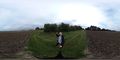
Panoramic (360°)) photo of the hashpoint, silly grin included

The Internet Was Here


Achievements
DanQ earned the Electric Vehicle Achievement
|
(I'm totally claiming the Subdivision geohash achievement once it's confirmed, too...)