Difference between revisions of "2024-01-01 49 11"
([live picture]At the hash) |
(→Achievements) |
||
| (4 intermediate revisions by 3 users not shown) | |||
| Line 1: | Line 1: | ||
| − | + | {{meetup graticule | |
| − | |||
| − | |||
| − | |||
| − | |||
| − | |||
| − | |||
| − | |||
| − | |||
| lat={{#explode:{{SUBPAGENAME}}| |1}} | | lat={{#explode:{{SUBPAGENAME}}| |1}} | ||
| lon={{#explode:{{SUBPAGENAME}}| |2}} | | lon={{#explode:{{SUBPAGENAME}}| |2}} | ||
| Line 13: | Line 5: | ||
}}<!-- edit as necessary --> | }}<!-- edit as necessary --> | ||
== Location == | == Location == | ||
| − | + | This Geohash is located on a meadow in Painten. | |
== Participants == | == Participants == | ||
| − | + | *[[User:Torodeas|Torodeas]] | |
| − | |||
| − | [[User:Torodeas|Torodeas]] | ||
| − | |||
| − | |||
| − | |||
== Expedition == | == Expedition == | ||
<!-- how it all turned out. your narrative goes here. --> | <!-- how it all turned out. your narrative goes here. --> | ||
| + | This expedition is a big one! I even invited [[User:Dawidi]] to come to this hash too, but I sadly didn't hear back. | ||
| + | |||
| + | As others have also noted, today's hash is at XX.00011. That's (in the nothern hemisphere at least) one of the most southerly points in a graticule, | ||
| + | and does allow to pick up some interesting areas for a [[Reverse_regional_achievement]]. That is true all over the world, and also true for this expedition. | ||
| + | |||
| + | If you partition [[49,11]] into districts you get: | ||
| + | {| class="wikitable" | ||
| + | !Name!!Geohash<br />probability | ||
| + | |- | ||
| + | |<span style="color:rgb(0, 128, 128)">■</span> Oberpfalz||45.9% | ||
| + | |- | ||
| + | |<span style="color:rgb(0, 255, 0)">■</span> Oberfranken||26.7% | ||
| + | |- | ||
| + | |<span style="color:rgb(255, 64, 191)">■</span> Mittelfranken||25.5% | ||
| + | |- | ||
| + | |<span style="color:rgb(0, 0, 255)">■</span> Oberbayern||1.5% | ||
| + | |- | ||
| + | |<span style="color:rgb(255, 191, 64)">■</span> Niederbayern||0.31% | ||
| + | |} | ||
| + | |||
| + | I've been to [[2023-12-28_49_11 | Mittelfranken]], [[2023-12-29_49_11 | Oberfranken]], and [[2023-10-28_49_11 | Oberpfalz]] in this graticule. | ||
| + | These are the easy ones. Today's hash is in Niederbayern. That's great, for two reasons. First, it is just a 0.3% chance for a 49,11 hash to be in Niederbayern. So you should expect it to happen once a year, right? | ||
| + | Well, yes. But these areas are not easy to access. Slight spoiler: It'll take me a whole day to get there (and back) today. If we assume I cannot take vacation without notice, I can only go for hashes like this on weekends (or on preplanned holiday), so my chances are further reduced to 0.0886%. That's three times in a decade. | ||
| + | Second, while I'm not ready to complete the reverse regional archievement for 49,11 (because I still lack Oberbayern), I have been to Oberbayern in [[2023-08-25_48_11 |another graticule (48,11)]], so today's hash will complete my subdivision of Bavaria. | ||
| + | |||
| + | But: Painten is great, but it's not easily accessible by public transport. In fact, it is not at all accessible by public transport today. It des have bus stops, but the first of January is a public holiday, so public transport runs as if it were a Sunday, and there are no busses to Painten on Sundays. | ||
| + | The nearest bus stop with service is 100 minutes by foot away from the hash. And that's just one way. And the bus stop (in Hohenschambach) has a bus - every other hour. So if I miss one, I'm going to be stuck there for 120 long minutes. | ||
| + | |||
| + | So after celebrating a happy new year with my friends yesterday, I get up at 9 am to go to the hash - and return by 7 pm if I'm lucky. Or 9pm. Did I already say it's not really accessible and I couldn't do that any day of the week? I did? Well, I hope I made my point. | ||
| − | + | It takes my 2.5 hours to get to the bus stop in Hohenschambach, where I arrive at 12:15. Hohenschambach is connected by busses to Regensburg, but I'm lucky and there's a connection in Undorf - so I can hop on the bus in a more westerly train station and can skip most of the 40 minutes bus ride from Regensburg central station. It only takes 10 minutes from Undorf to Hohenschambach, and now I'm on my own. ~6.5 km to the hash, by foot, 6.5km back afterwards, and hope that I make the earlier connection at 16:41. Considering I should need 200 minutes just to walk down to Painten and back up, it's even kind of possible to get the service at 14:41: Walking with regular speed would get me back by 15:35, so I need to shave off an hour or I have to wait until 16:41. But I usually walk faster than my search engine predicts. But I also might need some time to catch the hash, or might slow down during my >10km walk today. | |
| − | + | ||
| + | I did scout a nice route to walk the section from Hohenschambach to Painten: I first follow the tiny road down to Schacha, and when that road becomes the bigger road connecting Undorf and Painten, I'll enter the forest - and into Niederbayern (yes, there is a "bigger road" connecting Undorf and Painten. That doesn't mean it's a big road. The big road goes from Undorf to Hohenschambach, and that's where the bus runs. It's just a little bit too big to walk comfortably on it, as it does not have a sidewalk, but does have a car a minute). The path through the forest is longer - and makes my earlier connection even less likely - but if I spend a whole day on one expedition during my vacation, I better enjoy it. And I enjoy walking in a forest, I do not enjoy walking on a road. | ||
| + | |||
| + | Shortly after I enter the forest, I take my first picture: A tree has fallen and is blocking the path. If that's a sybol for today's expedition, I should just turn back. | ||
| + | I don't. Without any further obstacles, I arrive in Painten - and shortly after that, at 13:36, at the hash. While close to the houses in Painten, it is in some kind of accissable area and I take a picture and start walking back. | ||
| + | Reaching the hash at 13:36 is 15 minutes before expected time of arrival. So that's not even close to the half hour I should be ahead of schedule for the improbable connection that gets me home by 5pm. | ||
| + | To catch that, I would only be allowed an hour for the 6km on foot, and I really cannot do that. My previous hashes have all included at least some walking - that's how I like my hashes after all - and I've been walking since 12:15 more or less non stop. And I'm not a good runner nor interested in running that section. | ||
| + | I decide against trying it. If I'm in Painten for the first (and to be honest, probably last) time, I want to walk to its city center, see a bit of it, and - most important for me - take a different path back to Hohenschambach, | ||
| + | just to mix it up. | ||
| + | |||
| + | I'm back at the Hohenschambach bus stop at around 15:15. Which is - less than ideal. Half an hour late for the improbable connection, but 90 minutes from the next service at this town on Sudays. At least I brought a book. | ||
== Photos == | == Photos == | ||
| Line 34: | Line 60: | ||
--> | --> | ||
<gallery perrow="5"> | <gallery perrow="5"> | ||
| − | |||
Image:2024-01-01_49_11_Torodeas_1704139580271.jpg|A less than clear path [https://openstreetmap.org/?mlat=49.02153450&mlon=11.84158160&zoom=16 @49.0215,11.8416] | Image:2024-01-01_49_11_Torodeas_1704139580271.jpg|A less than clear path [https://openstreetmap.org/?mlat=49.02153450&mlon=11.84158160&zoom=16 @49.0215,11.8416] | ||
| Line 47: | Line 72: | ||
{{#vardefine:ribbonwidth|100%}} | {{#vardefine:ribbonwidth|100%}} | ||
<!-- Add any achievement ribbons you earned below, or remove this section --> | <!-- Add any achievement ribbons you earned below, or remove this section --> | ||
| + | {{consecutive geohash 3 | ||
| + | | hashcount = 7 | ||
| + | | daycount = 7 | ||
| + | | date = 2023-12-26 | ||
| + | | latitude = 49 | ||
| + | | longitude = 11 | ||
| + | | name = [[User:Torodeas|Torodeas]] | ||
| + | }} | ||
| − | + | {{land geohash | |
| − | |||
| − | |||
| − | |||
| − | |||
| − | |||
| − | + | | latitude = 49 | |
| + | | longitude = 11 | ||
| + | | date = 2024-01-01 | ||
| + | | name = [[User:Torodeas|Torodeas]] ([[User talk:Torodeas|talk]]) | ||
| − | + | }} | |
| + | {{public transport geohash | ||
| + | | latitude = 49 | ||
| + | | longitude = 11 | ||
| + | | date = 2024-01-01 | ||
| + | | name = [[User:Torodeas|Torodeas]] ([[User talk:Torodeas|talk]]) | ||
| + | | busline = RB11, S1, RB51, 28, RE50, U3, 70 | ||
| − | + | }} | |
| − | + | {{Subdivision geohash | |
| − | + | | name = [[User:Torodeas|Torodeas]] ([[User talk:Torodeas|talk]]) | |
| + | | region = Bavaria | ||
| + | | subdivisions = Districts | ||
| + | | count = 7 | ||
| + | }} | ||
| + | __NOTOC__ | ||
[[Category:Expeditions]] | [[Category:Expeditions]] | ||
| − | |||
[[Category:Expeditions with photos]] | [[Category:Expeditions with photos]] | ||
| − | |||
| − | |||
| − | |||
| − | |||
| − | |||
[[Category:Coordinates reached]] | [[Category:Coordinates reached]] | ||
| − | + | {{location|DE|BY|KEH}} | |
| − | |||
| − | |||
| − | |||
| − | |||
| − | |||
| − | |||
| − | |||
| − | |||
| − | |||
| − | |||
| − | |||
| − | |||
| − | |||
| − | |||
| − | |||
| − | |||
| − | |||
Latest revision as of 21:37, 5 March 2024
| Mon 1 Jan 2024 in 49,11: 49.0001178, 11.8192533 geohashing.info google osm bing/os kml crox |
Location
This Geohash is located on a meadow in Painten.
Participants
Expedition
This expedition is a big one! I even invited User:Dawidi to come to this hash too, but I sadly didn't hear back.
As others have also noted, today's hash is at XX.00011. That's (in the nothern hemisphere at least) one of the most southerly points in a graticule, and does allow to pick up some interesting areas for a Reverse_regional_achievement. That is true all over the world, and also true for this expedition.
If you partition 49,11 into districts you get:
| Name | Geohash probability |
|---|---|
| ■ Oberpfalz | 45.9% |
| ■ Oberfranken | 26.7% |
| ■ Mittelfranken | 25.5% |
| ■ Oberbayern | 1.5% |
| ■ Niederbayern | 0.31% |
I've been to Mittelfranken, Oberfranken, and Oberpfalz in this graticule. These are the easy ones. Today's hash is in Niederbayern. That's great, for two reasons. First, it is just a 0.3% chance for a 49,11 hash to be in Niederbayern. So you should expect it to happen once a year, right? Well, yes. But these areas are not easy to access. Slight spoiler: It'll take me a whole day to get there (and back) today. If we assume I cannot take vacation without notice, I can only go for hashes like this on weekends (or on preplanned holiday), so my chances are further reduced to 0.0886%. That's three times in a decade. Second, while I'm not ready to complete the reverse regional archievement for 49,11 (because I still lack Oberbayern), I have been to Oberbayern in another graticule (48,11), so today's hash will complete my subdivision of Bavaria.
But: Painten is great, but it's not easily accessible by public transport. In fact, it is not at all accessible by public transport today. It des have bus stops, but the first of January is a public holiday, so public transport runs as if it were a Sunday, and there are no busses to Painten on Sundays. The nearest bus stop with service is 100 minutes by foot away from the hash. And that's just one way. And the bus stop (in Hohenschambach) has a bus - every other hour. So if I miss one, I'm going to be stuck there for 120 long minutes.
So after celebrating a happy new year with my friends yesterday, I get up at 9 am to go to the hash - and return by 7 pm if I'm lucky. Or 9pm. Did I already say it's not really accessible and I couldn't do that any day of the week? I did? Well, I hope I made my point.
It takes my 2.5 hours to get to the bus stop in Hohenschambach, where I arrive at 12:15. Hohenschambach is connected by busses to Regensburg, but I'm lucky and there's a connection in Undorf - so I can hop on the bus in a more westerly train station and can skip most of the 40 minutes bus ride from Regensburg central station. It only takes 10 minutes from Undorf to Hohenschambach, and now I'm on my own. ~6.5 km to the hash, by foot, 6.5km back afterwards, and hope that I make the earlier connection at 16:41. Considering I should need 200 minutes just to walk down to Painten and back up, it's even kind of possible to get the service at 14:41: Walking with regular speed would get me back by 15:35, so I need to shave off an hour or I have to wait until 16:41. But I usually walk faster than my search engine predicts. But I also might need some time to catch the hash, or might slow down during my >10km walk today.
I did scout a nice route to walk the section from Hohenschambach to Painten: I first follow the tiny road down to Schacha, and when that road becomes the bigger road connecting Undorf and Painten, I'll enter the forest - and into Niederbayern (yes, there is a "bigger road" connecting Undorf and Painten. That doesn't mean it's a big road. The big road goes from Undorf to Hohenschambach, and that's where the bus runs. It's just a little bit too big to walk comfortably on it, as it does not have a sidewalk, but does have a car a minute). The path through the forest is longer - and makes my earlier connection even less likely - but if I spend a whole day on one expedition during my vacation, I better enjoy it. And I enjoy walking in a forest, I do not enjoy walking on a road.
Shortly after I enter the forest, I take my first picture: A tree has fallen and is blocking the path. If that's a sybol for today's expedition, I should just turn back. I don't. Without any further obstacles, I arrive in Painten - and shortly after that, at 13:36, at the hash. While close to the houses in Painten, it is in some kind of accissable area and I take a picture and start walking back. Reaching the hash at 13:36 is 15 minutes before expected time of arrival. So that's not even close to the half hour I should be ahead of schedule for the improbable connection that gets me home by 5pm. To catch that, I would only be allowed an hour for the 6km on foot, and I really cannot do that. My previous hashes have all included at least some walking - that's how I like my hashes after all - and I've been walking since 12:15 more or less non stop. And I'm not a good runner nor interested in running that section. I decide against trying it. If I'm in Painten for the first (and to be honest, probably last) time, I want to walk to its city center, see a bit of it, and - most important for me - take a different path back to Hohenschambach, just to mix it up.
I'm back at the Hohenschambach bus stop at around 15:15. Which is - less than ideal. Half an hour late for the improbable connection, but 90 minutes from the next service at this town on Sudays. At least I brought a book.
Photos
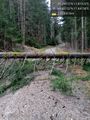
A less than clear path @49.0215,11.8416

Success
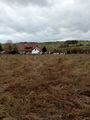
View from the hash

At the hash


Achievements
Torodeas earned the Consecutive geohash achievement
|
Torodeas (talk) earned the Land geohash achievement
|
Torodeas (talk) earned the Public transport geohash achievement
|
