Difference between revisions of "2023-05-09 45 -122"
Michael5000 (talk | contribs) (Created page with "{{subst:Expedition}}") |
m (subst-ing) |
||
| (9 intermediate revisions by 2 users not shown) | |||
| Line 1: | Line 1: | ||
| − | + | {{meetup graticule | |
| − | + | | lat=45 | |
| − | + | | lon=-122 | |
| − | + | | date=2023-05-09 | |
| − | |||
| − | |||
| − | |||
| − | |||
| − | |||
| − | | lat= | ||
| − | | lon= | ||
| − | | date= | ||
}}<!-- edit as necessary --> | }}<!-- edit as necessary --> | ||
== Location == | == Location == | ||
| − | + | A residential street near the I-205/WA-14 interchange in southeast Vancouver. | |
== Participants == | == Participants == | ||
| − | + | *[[user:Michael5000|Michael5000]] | |
| − | |||
| − | |||
| − | |||
| − | |||
== Expedition == | == Expedition == | ||
| − | + | After work I rode my bike up to the Columbia River, followed the bike path east past the airport (and past [[2023-04-23 45 -122]], and then turned north again over the long, charmless, and extremely loud bike path of the Glen Jackson Bridge. The hashpoint itself was on a quiet suburban street, all very nice but not much to see, so I started back to get home before dark. The whole trip was 26.6 miles, which I think is as far as I've ever gone for a purely bicycling expedition. | |
| − | + | '''UPDATE:''' I lied -- I had gone on a [[2010-07-30 45 -122|31-mile]] and a [[2010-07-18 45 -122|33-mile]] Expedition in 2010. But [[2023-05-14 45 -122|five days later]] I went on a 48-miler, the longest one for reals. | |
| − | |||
== Photos == | == Photos == | ||
| − | + | ||
| − | |||
| − | |||
<gallery perrow="5"> | <gallery perrow="5"> | ||
| + | File:2023-05-09 45 -122 1.jpg|Bicycle destinations in SW Washington | ||
| + | File:2023-05-09 45 -122 2.jpg|The hashpoint is at the nearest tree | ||
| + | File:2023-05-09 45 -122 5.jpg|I was there! | ||
| + | File:2023-05-09 45 -122 3.jpg|Returning on the I-205 bike path | ||
| + | File:2023-05-09 45 -122 4.jpg|The hashcot always enjoys crossing a state line | ||
</gallery> | </gallery> | ||
== Achievements == | == Achievements == | ||
{{#vardefine:ribbonwidth|100%}} | {{#vardefine:ribbonwidth|100%}} | ||
| − | + | {{bicycle geohash | |
| + | |||
| + | | latitude = 45 | ||
| + | | longitude = -122 | ||
| + | | date = 2023-05-09 | ||
| + | | name = Michael5000 | ||
| + | | distance = 26.6 miles | ||
| + | | bothways = true | ||
| + | |||
| + | }} | ||
__NOTOC__ | __NOTOC__ | ||
| − | |||
| − | |||
| − | |||
| − | |||
| − | |||
| − | |||
| − | |||
| − | |||
| − | |||
| − | |||
| − | |||
| − | |||
| − | |||
[[Category:Expeditions]] | [[Category:Expeditions]] | ||
| − | |||
[[Category:Expeditions with photos]] | [[Category:Expeditions with photos]] | ||
| − | |||
| − | |||
| − | |||
| − | |||
| − | |||
[[Category:Coordinates reached]] | [[Category:Coordinates reached]] | ||
| − | + | {{location|US|WA|CR}} | |
| − | |||
| − | |||
| − | |||
| − | |||
| − | |||
| − | |||
| − | |||
| − | |||
| − | |||
| − | |||
| − | |||
| − | |||
| − | |||
| − | |||
| − | |||
| − | |||
| − | |||
Latest revision as of 20:59, 24 May 2024
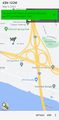
| Tue 9 May 2023 in 45,-122: 45.6070553, -122.5572263 geohashing.info google osm bing/os kml crox |
Location
A residential street near the I-205/WA-14 interchange in southeast Vancouver.
Participants
Expedition
After work I rode my bike up to the Columbia River, followed the bike path east past the airport (and past 2023-04-23 45 -122, and then turned north again over the long, charmless, and extremely loud bike path of the Glen Jackson Bridge. The hashpoint itself was on a quiet suburban street, all very nice but not much to see, so I started back to get home before dark. The whole trip was 26.6 miles, which I think is as far as I've ever gone for a purely bicycling expedition.
UPDATE: I lied -- I had gone on a 31-mile and a 33-mile Expedition in 2010. But five days later I went on a 48-miler, the longest one for reals.
Photos
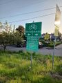
Bicycle destinations in SW Washington
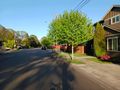
The hashpoint is at the nearest tree
I was there!
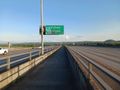
Returning on the I-205 bike path
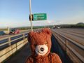
The hashcot always enjoys crossing a state line


Achievements
Michael5000 earned the Bicycle geohash achievement
|