imported>Tjtrumpet2323 |
imported>Tjtrumpet2323 |
| (18 intermediate revisions by the same user not shown) |
| Line 1: |
Line 1: |
| | + | {{User:Tjtrumpet2323/sandbox}} |
| | <!-- | | <!-- |
| | | | |
| Line 7: |
Line 8: |
| | ! <h2 style="margin:0; background:#cef2e0; font-size:120%; font-weight:bold; border:1px solid #a3bfb1; text-align:left; color:#000; padding:0.2em 0.4em;">Welcome</h2> | | ! <h2 style="margin:0; background:#cef2e0; font-size:120%; font-weight:bold; border:1px solid #a3bfb1; text-align:left; color:#000; padding:0.2em 0.4em;">Welcome</h2> |
| | |- | | |- |
| − | |style="color:#000;"| Welcome to the '''Geohashing Community Wiki'''. [[Geohashing]] is a ''Spontaneous Adventure Generator'', brought to you by the [[xkcd]] webcomic. | + | |style="color:#000;"| {{Welcome}} |
| − | | |
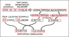
| − | [[Image:Coordinates.png|right|240 px|[[The Algorithm]], as shown in [[xkcd]] [http://www.xkcd.com/426/ comic #426].]]
| |
| − | [[xkcd]] [http://www.xkcd.com/426/ comic #426], published on 21 May 2008, contains an [[algorithm]] that generates random coordinates around the world every day. Everyone in a given [[Graticule|region]] gets the same set of coordinates. As such, these coordinates can be used as destinations for adventures, ''à la'' [http://en.wikipedia.org/wiki/Geocaching Geocaching], or for local meetups.
| |
| − | | |
| − | For a little more interactive discussion, consider joining [irc://irc.foonetic.net/geohashing the #geohashing IRC channel] on Foonetic.
| |
| − | |-
| |
| − | ! <h2 style="margin:0; background:#cef2e0; font-size:120%; font-weight:bold; border:1px solid #a3bfb1; text-align:left; color:#000; padding:0.2em 0.4em;">How it works</h2>
| |
| − | |-
| |
| − | |style="color:#000;"| '''Play with the coordinate calculator at [http://xkcd.com/geohashing http://xkcd.com/geohashing].''' All coordinates refer to the [[wikipedia:WGS84|WGS84]] datum.
| |
| − | | |
| − | Every day, the [[algorithm]] generates a new set of coordinates for each 1°×1° latitude/longitude zone (known as a [[graticule]]) in the world. They are randomly placed -- they could be in the forest, in a city, on a mountain, or even in the middle of a lake! You can use this wiki to document the daily coordinates (geohashes) you've been to.
| |
| − | | |
| − | {{disclaimer}} | |
| − | | |
| − | Unless you can accurately predict the [[DJIA|stock market]] down to the penny, you can't figure out what the coordinates will be ahead of time. You can first calculate a weekday's coordinates at about 09:30 [[ET]], and on Friday you can calculate the coordinates for each day that weekend.
| |
| − | | |
| − | When visiting geohash locations, please [[geotrashing|respect the area]] you are visiting. Absolutely do not litter or otherwise disturb the natural integrity of the area. However, if possible, creating some kind of a marker out of nearby materials (i.e. cairn of stones, blair-witch-style 'stick figures', etc.) is encouraged.
| |
| | |- | | |- |
| | ! <h2 style="margin:0; background:#cef2e0; font-size:120%; font-weight:bold; border:1px solid #a3bfb1; text-align:left; color:#000; padding:0.2em 0.4em;">Official xkcd meetups</h2> | | ! <h2 style="margin:0; background:#cef2e0; font-size:120%; font-weight:bold; border:1px solid #a3bfb1; text-align:left; color:#000; padding:0.2em 0.4em;">Official xkcd meetups</h2> |
| | |- | | |- |
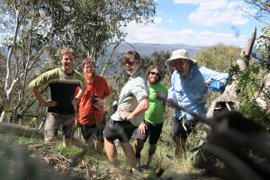
| − | |style="color:#000;"| [[Image:Noterminal portland sample_2.jpg|right|222 px|[[User:NoTerminal|NoTerminal]] and [[User:Drache|Drache]] at the [[2008-02-19 45 -122|19 February 2008 coordinates]] for Portland, Oregon]] | + | |style="color:#000;"| {{:Saturday meetup}} |
| − | Official [[xkcd]] meetups happen every Saturday afternoon at that day's normal geohash coordinates. All meetups start at 16:00* (local destination time). If you go at these times, you might encounter other readers of xkcd. Bring games!
| |
| − | | |
| − | In such cases when it is unwise to attempt to access the generated coordinates, the [[Saturday meetup]] is postponed until a day when the algorithm provides a more suitable location. Alternatively, when the coordinates fall within a body of water, you can rent a boat and win the [[Water Geohash]] achievement.
| |
| − | | |
| − | {{footnote|
| |
| − | * In some areas, 16:00 is too close to sunset during the winter, so earlier meetups are often more appropriate. See [[All Graticules|individual graticule pages]] for local conventions.}}
| |
| | |- | | |- |
| | |} | | |} |
| Line 42: |
Line 20: |
| | |class="MainPageBG" style="width:45%; border:1px solid #cedff2; background:#f5faff; vertical-align:top;"| | | |class="MainPageBG" style="width:45%; border:1px solid #cedff2; background:#f5faff; vertical-align:top;"| |
| | {| width="100%" cellpadding="2" cellspacing="5" style="vertical-align:top; background:#f5faff;" | | {| width="100%" cellpadding="2" cellspacing="5" style="vertical-align:top; background:#f5faff;" |
| − | |style="color:#000;"| <div style="font-size: 88%; text-align: center;">'''Server Time:''' {{ #time: l j F Y, H:i | {{CURRENTTIMESTAMP}} }} (UTC) – <span class="plainlinks" id="purgelink">[{{fullurl:{{FULLPAGENAME}}|action=purge}} Refresh this page]</span></div> | + | |style="color:#000;"| {{Server time}} |
| | + | |- |
| | + | ! <h2 style="margin:0; background:#cedff2; font-size:120%; font-weight:bold; border:1px solid #a3b0bf; text-align:left; color:#000; padding:0.2em 0.4em;">Getting started</h2> |
| | + | |- |
| | + | |style="color:#000;"| {{Getting started}} |
| | |- | | |- |
| | ! <h2 style="margin:0; background:#cedff2; font-size:120%; font-weight:bold; border:1px solid #a3b0bf; text-align:left; color:#000; padding:0.2em 0.4em;">Coordinates</h2> | | ! <h2 style="margin:0; background:#cedff2; font-size:120%; font-weight:bold; border:1px solid #a3b0bf; text-align:left; color:#000; padding:0.2em 0.4em;">Coordinates</h2> |
| | |- | | |- |
| − | |style="color:#000;"| <!-- THIS AUTOMATICALLY UPDATES ONCE THE DOW OPENS TO GIVE THE NEXT SATURDAY'S COORDS AND REWORDS ITSELF IN THE VICINITY OF A SATURDAY. CONTACT User:Tjtrumpet2323 WITH CONCERNS. --> | + | |style="color:#000;"| <!-- |
| − | {{Next Saturday}}
| |
| | | | |
| − | <!-- RECOMMENDED THAT EIGHT (8) DAYS BE KEPT HERE; LONG-TERM GOAL IS TO AUTOMATE THIS EVENTUALLY --Tjtrumpet2323 (6/5/08 16:16 UTC) -->
| + | THIS SECTION HAS BEEN COMPLETELY AUTOMATED BY User:Tjtrumpet2323. LEAVE MESSAGES ON HIS TALK PAGE WITH CONCERNS. |
| − | {| class="wikitable" style="font-size: 88%; text-align: center; vertical-align: top; border: 3px solid black; border-collapse: collapse; margin: 1em" border="1" cellpadding="2"
| + | |
| − | ! Date !! West of [[30W Time Zone Rule|-30°]] !! East of -30°
| + | -->{{Next Saturday}} |
| − | |-
| + | |
| − | ! {{datelink|2008-06-17|D d M}}
| + | * {{Coordinates list}} |
| − | | ''Announced 13:30 UTC, 17 June.'' || 0.3042243, 0.1316005
| + | * {{Expedition archive recent}} |
| − | |-
| + | * [{{fullurl:{{FULLPAGENAME}}|action=purge}} Refresh the cache] |
| − | ! {{datelink|2008-06-16|D d M}}
| |
| − | | 0.4015923, 0.1894812 || 0.6548626, 0.6964018
| |
| − | |-
| |
| − | ! {{datelink|2008-06-15|D d M}}
| |
| − | | colspan=2 | 0.4753808, 0.7612767
| |
| − | |-
| |
| − | ! {{datelink|2008-06-14|D d M}}
| |
| − | | colspan=2 | 0.8067463, 0.0388869
| |
| − | |-
| |
| − | ! {{datelink|2008-06-13|D d M}}
| |
| − | | 0.5763790, 0.1583778 || 0.3216960, 0.2789543
| |
| − | |-
| |
| − | ! {{datelink|2008-06-12|D d M}}
| |
| − | | 0.5114489, 0.6332663 || 0.7906706, 0.3355328
| |
| − | |-
| |
| − | ! {{datelink|2008-06-11|D d M}}
| |
| − | | 0.4657200, 0.7263600 || 0.5535325, 0.3987999
| |
| − | |-
| |
| − | ! {{datelink|2008-06-10|D d M}}
| |
| − | | 0.8758452, 0.0997684 || 0.0930472, 0.5111978
| |
| − | |} | |
| − | {{expedition archive recent}}
| |
| − | |-
| |
| − | ! <h2 style="margin:0; background:#cedff2; font-size:120%; font-weight:bold; border:1px solid #a3b0bf; text-align:left; color:#000; padding:0.2em 0.4em;">Find others in your area!</h2>
| |
| − | |-
| |
| − | |style="color:#000;"| Want to find geohashers in your local area? See [[:Category:Active Graticules]] for a list of graticules with active users in them.
| |
| − | * Don't see your home area? Follow the format and create a page for it! We'd love to have you!
| |
| − | * An interactive map is available for [http://irc.peeron.com/xkcd/map/data/graticule.kml Google Earth] or on [http://maps.google.com/maps?f=q&hl=en&geocode=&q=http:%2F%2Firc.peeron.com%2Fxkcd%2Fmap%2Fdata%2Fgraticule.kml&ie=UTF8&ll=42.811522,-71.773682&spn=6.051885,9.733887&z=7 Google Maps].
| |
| − | * You can also attach your photos to this [http://maps.google.com/maps/ms?hl=en&ie=UTF8&oe=UTF8&msa=0&msid=102381707694098607871.00044e6104ed42cdc2ff4 Google Maps layer].
| |
| − | |-
| |
| − | ! <h2 style="margin:0; background:#cedff2; font-size:120%; font-weight:bold; border:1px solid #a3b0bf; text-align:left; color:#000; padding:0.2em 0.4em;">Implementations</h2>
| |
| − | |-
| |
| − | |style="color:#000;"| A full list of reference and practical implementations can be found on the [[Implementations]] page.
| |
| | |- | | |- |
| | |} | | |} |


